Armstrong Creek Topo Map Wisconsin
To zoom in, hover over the map of Armstrong Creek
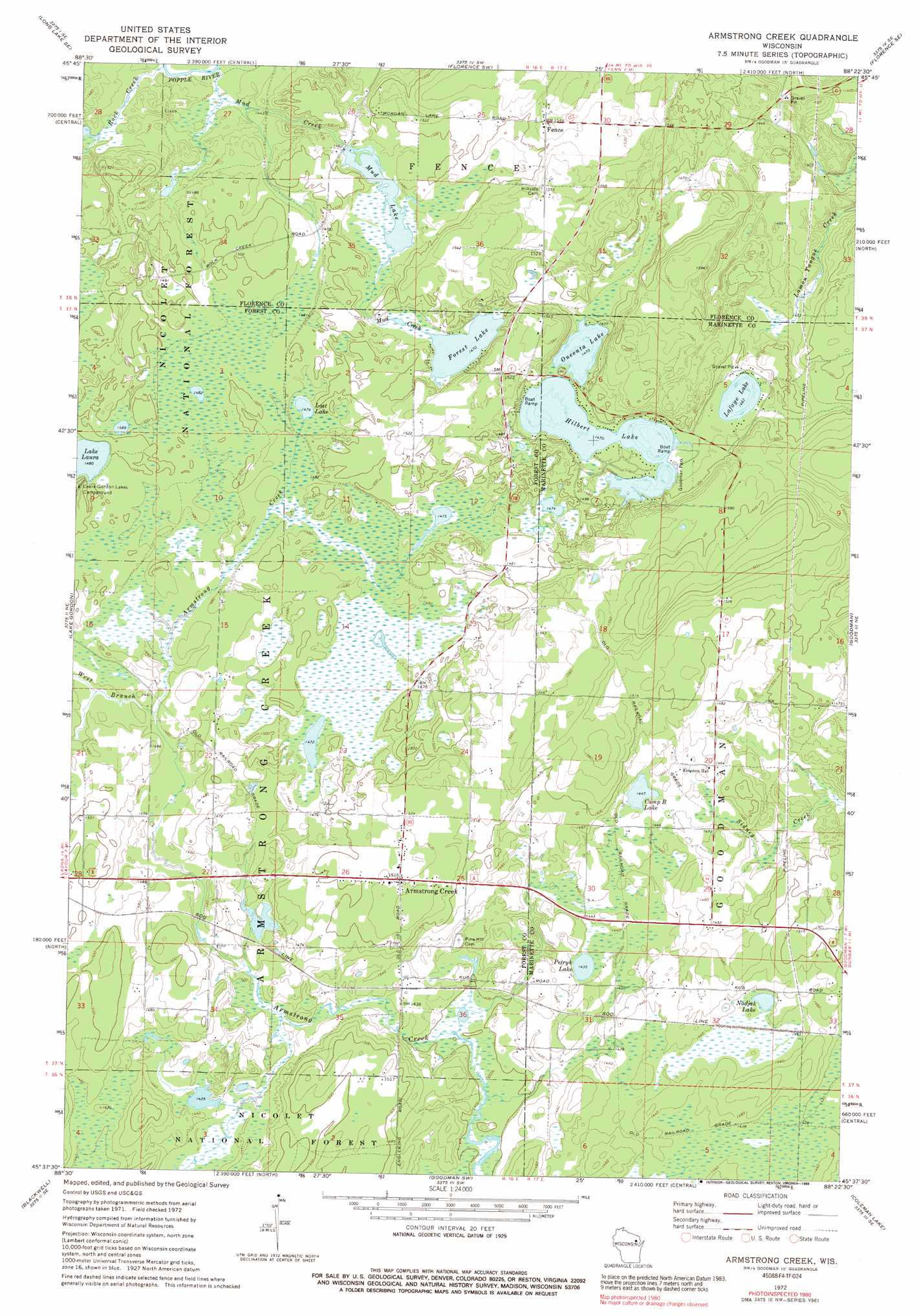
USGS Topo Quad 45088f4 - 1:24,000 scale
| Topo Map Name: | Armstrong Creek |
| USGS Topo Quad ID: | 45088f4 |
| Print Size: | ca. 21 1/4" wide x 27" high |
| Southeast Coordinates: | 45.625° N latitude / 88.375° W longitude |
| Map Center Coordinates: | 45.6875° N latitude / 88.4375° W longitude |
| U.S. State: | WI |
| Filename: | o45088f4.jpg |
| Download Map JPG Image: | Armstrong Creek topo map 1:24,000 scale |
| Map Type: | Topographic |
| Topo Series: | 7.5´ |
| Map Scale: | 1:24,000 |
| Source of Map Images: | United States Geological Survey (USGS) |
| Alternate Map Versions: |
Armstrong Creek WI 1972, updated 1974 Download PDF Buy paper map Armstrong Creek WI 1972, updated 1989 Download PDF Buy paper map Armstrong Creek WI 2011 Download PDF Buy paper map Armstrong Creek WI 2013 Download PDF Buy paper map Armstrong Creek WI 2015 Download PDF Buy paper map |
| FStopo: | US Forest Service topo Armstrong Creek is available: Download FStopo PDF Download FStopo TIF |
1:24,000 Topo Quads surrounding Armstrong Creek
Tipler |
Long Lake Ne |
Naults |
Florence West |
Florence East |
Long Lake |
Long Lake Se |
Florence Sw |
Florence Se |
Iron Mountain Sw |
Newald |
Lake Gordon |
Armstrong Creek |
Goodman |
Dunbar |
Laona |
Blackwell |
Goodman Sw |
Coleman Lake |
Twelvefoot Falls |
Wabeno |
Otter Lake |
Mccaslin Mountain |
Roaring Rapids |
Lehman Lake |
> Back to 45088e1 at 1:100,000 scale
> Back to 45088a1 at 1:250,000 scale
> Back to U.S. Topo Maps home
Armstrong Creek topo map: Gazetteer
Armstrong Creek: Dams
Mud Creek D7777 Dam elevation 451m 1479′Armstrong Creek: Lakes
Camp B Lake elevation 441m 1446′Forest Lake elevation 448m 1469′
Hilbert Lake elevation 448m 1469′
LaFaye Lake elevation 446m 1463′
Lost Lake elevation 449m 1473′
Mud Lake elevation 447m 1466′
Nadjak Lake elevation 436m 1430′
Oneonta Lake elevation 449m 1473′
Petryk Lake elevation 437m 1433′
Armstrong Creek: Parks
Goodman Park elevation 450m 1476′Armstrong Creek: Populated Places
Armstrong Creek elevation 463m 1519′Fence elevation 469m 1538′
Armstrong Creek: Reservoirs
Mud Lake elevation 451m 1479′Armstrong Creek: Streams
Mud Creek elevation 432m 1417′Rock Creek elevation 431m 1414′
West Branch Armstrong Creek elevation 442m 1450′
Armstrong Creek digital topo map on disk
Buy this Armstrong Creek topo map showing relief, roads, GPS coordinates and other geographical features, as a high-resolution digital map file on DVD: