Naults Topo Map Wisconsin
To zoom in, hover over the map of Naults
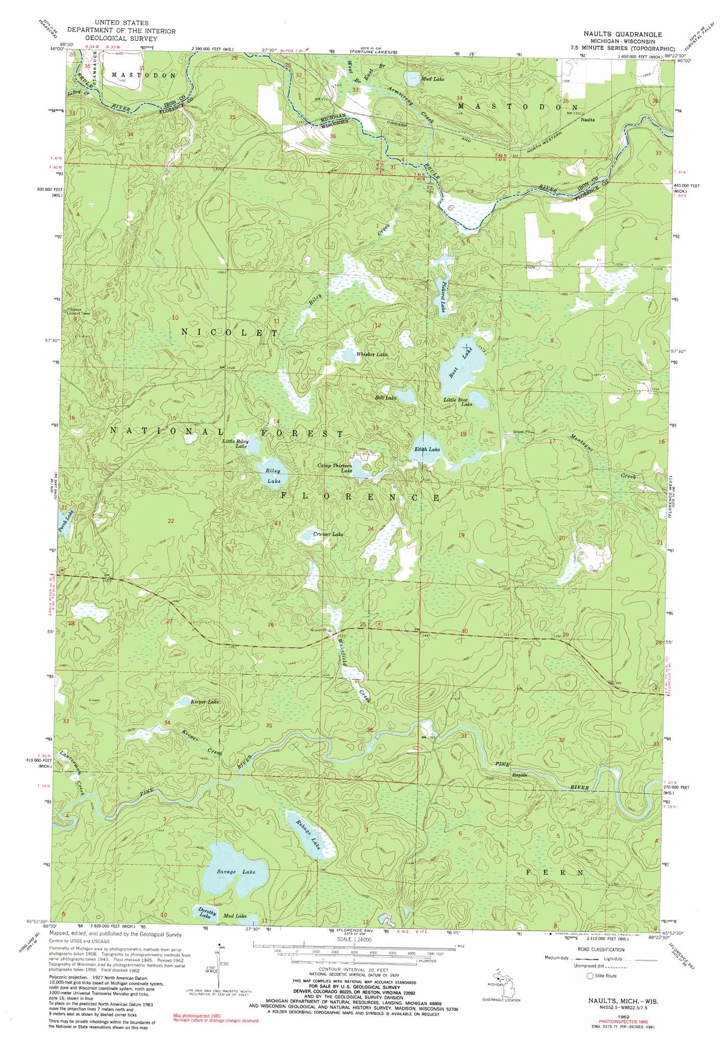
USGS Topo Quad 45088h4 - 1:24,000 scale
| Topo Map Name: | Naults |
| USGS Topo Quad ID: | 45088h4 |
| Print Size: | ca. 21 1/4" wide x 27" high |
| Southeast Coordinates: | 45.875° N latitude / 88.375° W longitude |
| Map Center Coordinates: | 45.9375° N latitude / 88.4375° W longitude |
| U.S. States: | WI, MI |
| Filename: | o45088h4.jpg |
| Download Map JPG Image: | Naults topo map 1:24,000 scale |
| Map Type: | Topographic |
| Topo Series: | 7.5´ |
| Map Scale: | 1:24,000 |
| Source of Map Images: | United States Geological Survey (USGS) |
| Alternate Map Versions: |
Naults MI 1947 Download PDF Buy paper map Naults MI 1962, updated 1964 Download PDF Buy paper map Naults MI 1962, updated 1981 Download PDF Buy paper map Naults MI 1962, updated 1981 Download PDF Buy paper map Naults MI 2011 Download PDF Buy paper map Naults MI 2013 Download PDF Buy paper map Naults MI 2014 Download PDF Buy paper map Naults MI 2016 Download PDF Buy paper map |
| FStopo: | US Forest Service topo Naults is available: Download FStopo PDF Download FStopo TIF |
1:24,000 Topo Quads surrounding Naults
Gibbs City |
Sunset Lake |
Amasa |
Kelso Junction |
Kiernan |
Iron River |
Gaastra |
Fortune Lakes |
Crystal Falls |
Lake Mary |
Tipler |
Long Lake Ne |
Naults |
Florence West |
Florence East |
Long Lake |
Long Lake Se |
Florence Sw |
Florence Se |
Iron Mountain Sw |
Newald |
Lake Gordon |
Armstrong Creek |
Goodman |
Dunbar |
> Back to 45088e1 at 1:100,000 scale
> Back to 45088a1 at 1:250,000 scale
> Back to U.S. Topo Maps home
Naults topo map: Gazetteer
Naults: Lakes
Bell Lake elevation 418m 1371′Boot Lake elevation 417m 1368′
Camp Thirteen Lake elevation 423m 1387′
Cruiser Lake elevation 438m 1437′
Dorothy Lake elevation 430m 1410′
Edith Lake elevation 416m 1364′
Kieper Lake elevation 436m 1430′
Little Boot Lake elevation 417m 1368′
Little Riley Lake elevation 430m 1410′
Mud Lake elevation 430m 1410′
Mud Lake elevation 408m 1338′
Pickerel Lake elevation 399m 1309′
Riley Lake elevation 430m 1410′
Robago Lake elevation 424m 1391′
Savage Lake elevation 430m 1410′
Whisker Lake elevation 417m 1368′
Naults: Parks
Fox Maple Woods State Natural Area elevation 441m 1446′Naults: Populated Places
Naults elevation 412m 1351′Naults: Streams
Armstrong Creek elevation 399m 1309′East Branch Armstrong Creek elevation 401m 1315′
Kieper Creek elevation 421m 1381′
Lauterman Creek elevation 431m 1414′
LeRoy Creek elevation 413m 1354′
Riley Creek elevation 397m 1302′
Wakefield Creek elevation 414m 1358′
West Branch Armstrong Creek elevation 401m 1315′
Naults digital topo map on disk
Buy this Naults topo map showing relief, roads, GPS coordinates and other geographical features, as a high-resolution digital map file on DVD: