Woodboro Topo Map Wisconsin
To zoom in, hover over the map of Woodboro
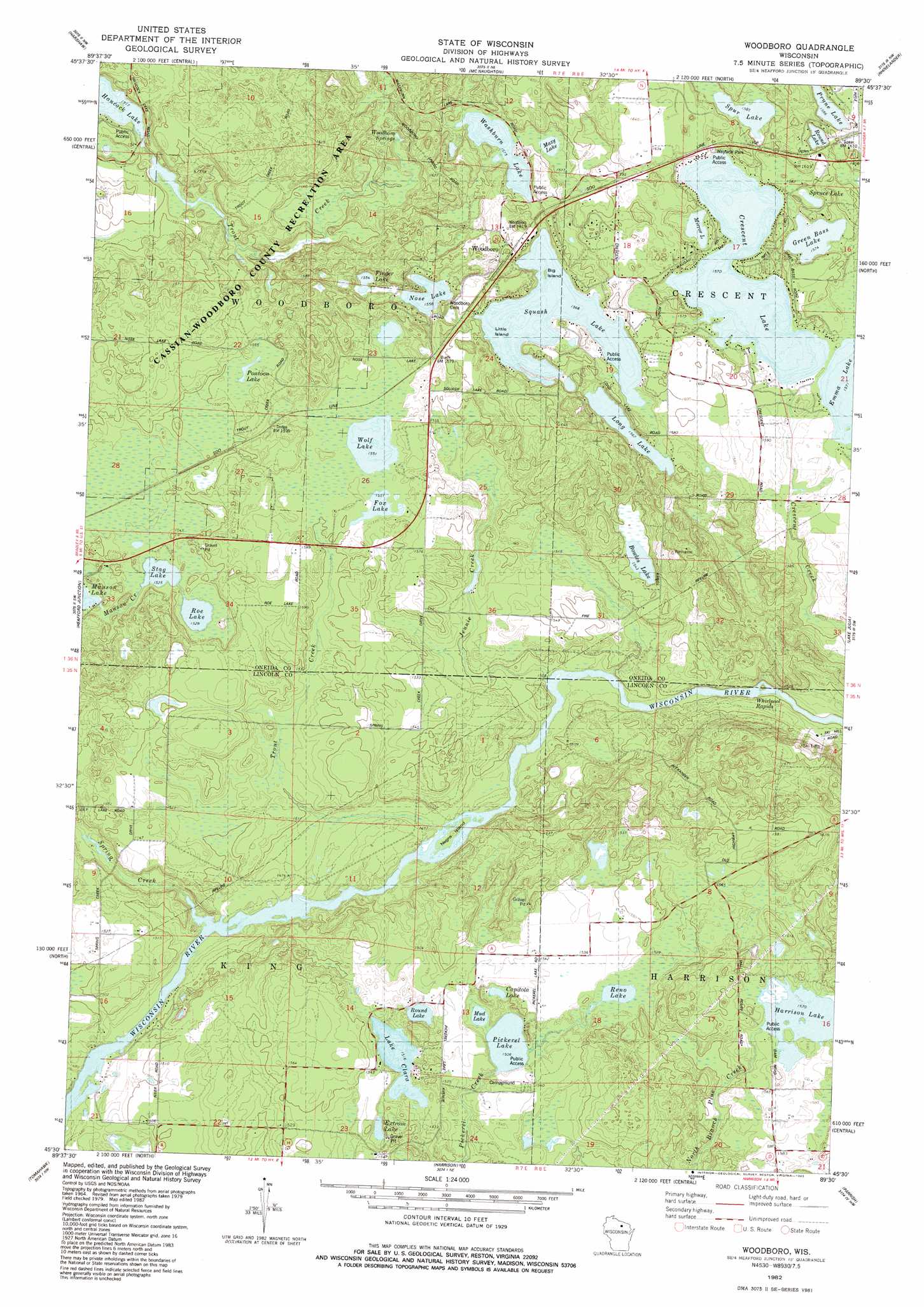
USGS Topo Quad 45089e5 - 1:24,000 scale
| Topo Map Name: | Woodboro |
| USGS Topo Quad ID: | 45089e5 |
| Print Size: | ca. 21 1/4" wide x 27" high |
| Southeast Coordinates: | 45.5° N latitude / 89.5° W longitude |
| Map Center Coordinates: | 45.5625° N latitude / 89.5625° W longitude |
| U.S. State: | WI |
| Filename: | o45089e5.jpg |
| Download Map JPG Image: | Woodboro topo map 1:24,000 scale |
| Map Type: | Topographic |
| Topo Series: | 7.5´ |
| Map Scale: | 1:24,000 |
| Source of Map Images: | United States Geological Survey (USGS) |
| Alternate Map Versions: |
Woodboro WI 1982, updated 1983 Download PDF Buy paper map Woodboro WI 2010 Download PDF Buy paper map Woodboro WI 2013 Download PDF Buy paper map Woodboro WI 2015 Download PDF Buy paper map |
1:24,000 Topo Quads surrounding Woodboro
Mercer Lake |
Hazelhurst |
Lake Tomahawk |
Dam Lake |
Sugar Camp |
Burrows Lake |
Harshaw |
Mcnaughton |
Reinlander |
Moen Laek |
Bradley |
Heafford Junction |
Woodboro |
Lake Julia |
George Lake |
Coffee Creek |
Tomahawk |
Harrison |
Parrish |
Enterprise |
Grandfather Falls |
Irma |
Bloomville |
Gleason |
Bavaria |
> Back to 45089e1 at 1:100,000 scale
> Back to 45088a1 at 1:250,000 scale
> Back to U.S. Topo Maps home
Woodboro topo map: Gazetteer
Woodboro: Dams
Harrison 2WP351 Dam elevation 479m 1571′Woodboro: Islands
Big Island elevation 478m 1568′Little Island elevation 478m 1568′
Negro Island elevation 451m 1479′
Woodboro: Lakes
Bowles Lake elevation 470m 1541′Capitola Lake elevation 463m 1519′
Crescent Lake elevation 479m 1571′
Extrom Lake elevation 461m 1512′
Finger Lake elevation 474m 1555′
Fox Lake elevation 473m 1551′
Green Bass Lake elevation 480m 1574′
Harrison Lake elevation 479m 1571′
Lake Clara elevation 462m 1515′
Long Lake elevation 478m 1568′
Mazy Lake elevation 479m 1571′
Mirror Lake elevation 480m 1574′
Mud Lake elevation 458m 1502′
Nose Lake elevation 475m 1558′
Pickerel Lake elevation 458m 1502′
Pontoon Lake elevation 474m 1555′
Prune Lake elevation 483m 1584′
Reno Lake elevation 465m 1525′
Roe Lake elevation 466m 1528′
Round Lake elevation 462m 1515′
Round Lake elevation 484m 1587′
Spruce Lake elevation 484m 1587′
Spur Lake elevation 483m 1584′
Squash Lake elevation 478m 1568′
Stag Lake elevation 465m 1525′
Washburn Lake elevation 480m 1574′
Wolf Lake elevation 473m 1551′
Woodboro: Populated Places
Woodboro elevation 489m 1604′Woodboro: Rapids
Whirlpool Rapids elevation 454m 1489′Woodboro: Reservoirs
Harrison Lake 6 elevation 479m 1571′Woodboro: Springs
Woodboro Springs elevation 475m 1558′Woodboro: Streams
Jennie Creek elevation 451m 1479′Spring Creek elevation 444m 1456′
Trout Creek elevation 446m 1463′
Trout Creek elevation 463m 1519′
Woodboro digital topo map on disk
Buy this Woodboro topo map showing relief, roads, GPS coordinates and other geographical features, as a high-resolution digital map file on DVD: