Lac Du Flambeau Sw Topo Map Wisconsin
To zoom in, hover over the map of Lac Du Flambeau Sw
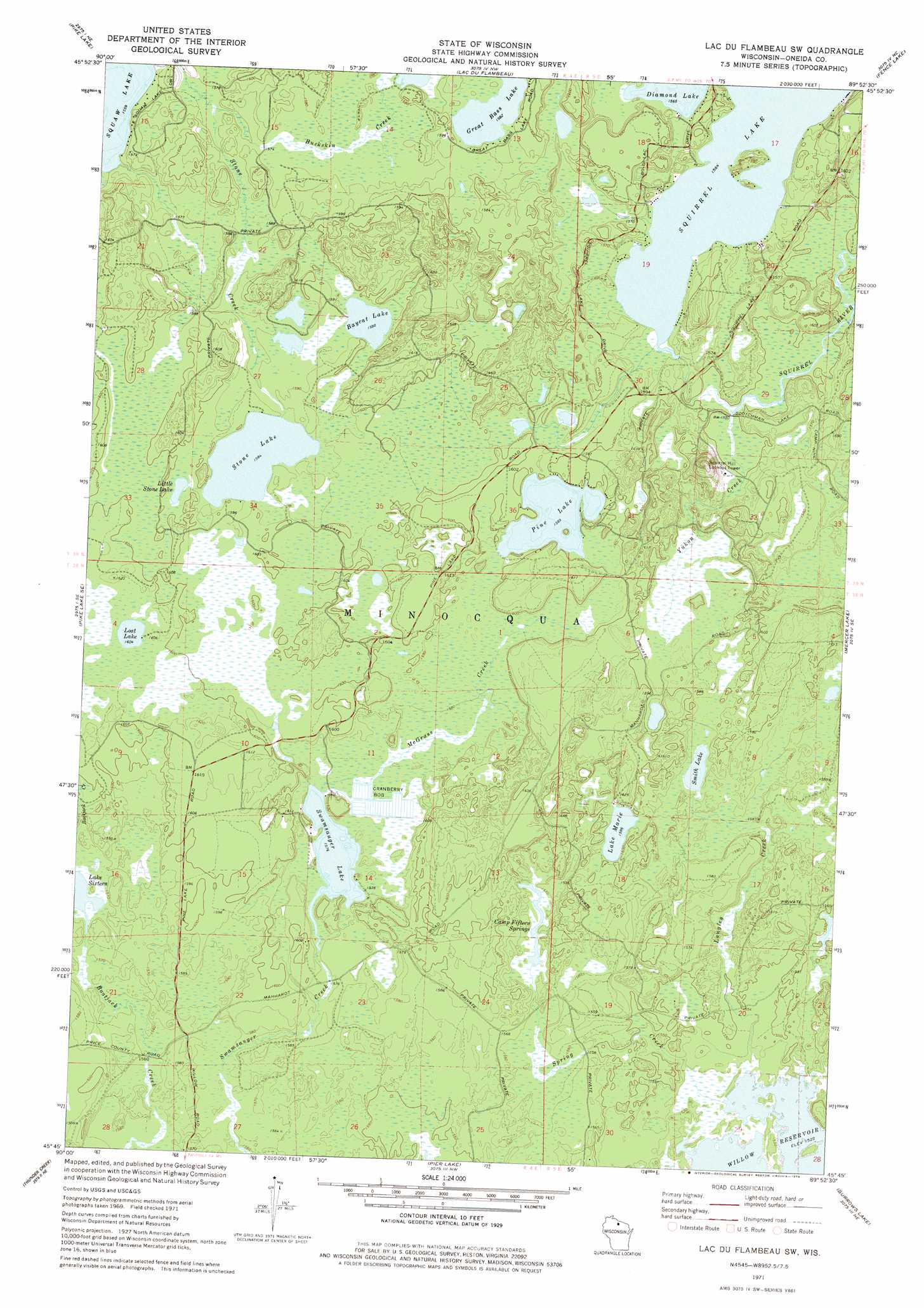
USGS Topo Quad 45089g8 - 1:24,000 scale
| Topo Map Name: | Lac Du Flambeau Sw |
| USGS Topo Quad ID: | 45089g8 |
| Print Size: | ca. 21 1/4" wide x 27" high |
| Southeast Coordinates: | 45.75° N latitude / 89.875° W longitude |
| Map Center Coordinates: | 45.8125° N latitude / 89.9375° W longitude |
| U.S. State: | WI |
| Filename: | o45089g8.jpg |
| Download Map JPG Image: | Lac Du Flambeau Sw topo map 1:24,000 scale |
| Map Type: | Topographic |
| Topo Series: | 7.5´ |
| Map Scale: | 1:24,000 |
| Source of Map Images: | United States Geological Survey (USGS) |
| Alternate Map Versions: |
Lac Du Flambeau SW WI 1971, updated 1973 Download PDF Buy paper map Lac Du Flambeau SW WI 1971, updated 1979 Download PDF Buy paper map Lac du Flambeau SW WI 2010 Download PDF Buy paper map Lac du Flambeau SW WI 2013 Download PDF Buy paper map Lac du Flambeau SW WI 2015 Download PDF Buy paper map |
1:24,000 Topo Quads surrounding Lac Du Flambeau Sw
Turtle-Flambeau Flowage |
Wilson Lake |
Powell |
Manitowish Lake |
Boulder Junction |
Pike Lake Nw |
Pike Lake |
Lac Du Flambeau |
Fence Lake |
Woodruff |
Pike Lake Sw |
Pike Lake Se |
Lac Du Flambeau Sw |
Mercer Lake |
Hazelhurst |
Dover |
Thunder Creek |
Pier Lake |
Burrows Lake |
Harshaw |
Big Briens Lake |
Brantwood |
Tripoli |
Bradley |
Heafford Junction |
> Back to 45089e1 at 1:100,000 scale
> Back to 45088a1 at 1:250,000 scale
> Back to U.S. Topo Maps home
Lac Du Flambeau Sw topo map: Gazetteer
Lac Du Flambeau Sw: Lakes
Baycat Lake elevation 484m 1587′Diamond Lake elevation 477m 1564′
Great Bass Lake elevation 482m 1581′
Lake Marie elevation 483m 1584′
Lake Sixteen elevation 477m 1564′
Little Stone Lake elevation 486m 1594′
Lost Lake elevation 489m 1604′
My Lake elevation 479m 1571′
Pine Lake elevation 484m 1587′
Smith Lake elevation 480m 1574′
Stone Lake elevation 483m 1584′
Swamsauger Lake elevation 480m 1574′
Lac Du Flambeau Sw: Reservoirs
Squirrel Lake elevation 477m 1564′Lac Du Flambeau Sw: Springs
Camp Fifteen Springs elevation 478m 1568′Lac Du Flambeau Sw: Streams
Buckskin Creek elevation 478m 1568′Langley Creek elevation 466m 1528′
McGrass Creek elevation 480m 1574′
Spring Creek elevation 464m 1522′
Stone Creek elevation 475m 1558′
Yukon Creek elevation 472m 1548′
Lac Du Flambeau Sw digital topo map on disk
Buy this Lac Du Flambeau Sw topo map showing relief, roads, GPS coordinates and other geographical features, as a high-resolution digital map file on DVD: