Fence Lake Topo Map Wisconsin
To zoom in, hover over the map of Fence Lake
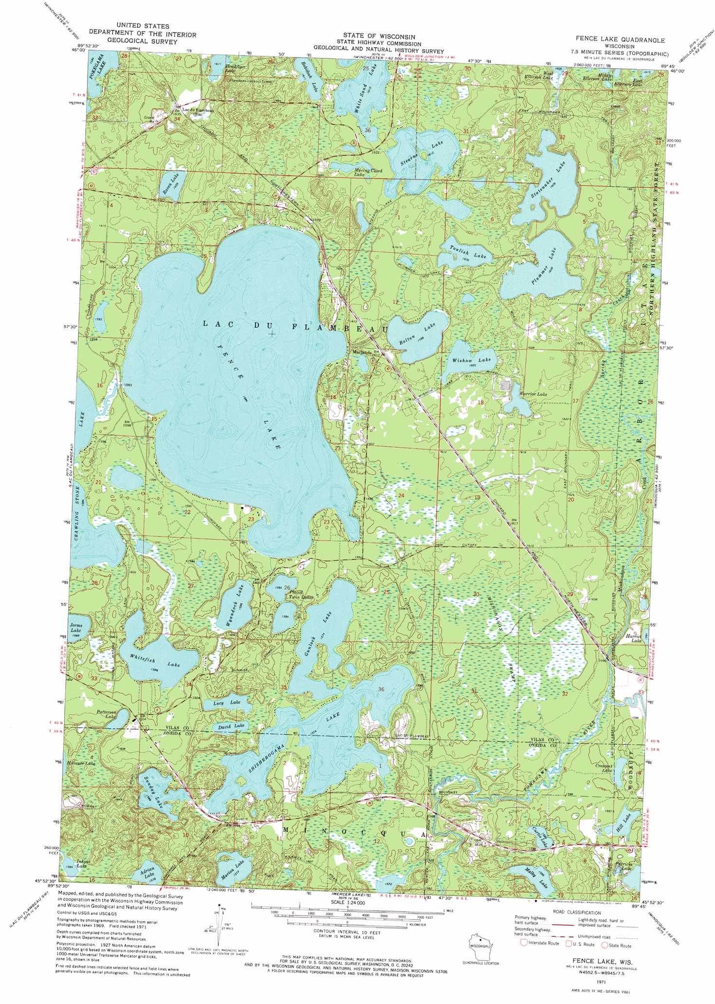
USGS Topo Quad 45089h7 - 1:24,000 scale
| Topo Map Name: | Fence Lake |
| USGS Topo Quad ID: | 45089h7 |
| Print Size: | ca. 21 1/4" wide x 27" high |
| Southeast Coordinates: | 45.875° N latitude / 89.75° W longitude |
| Map Center Coordinates: | 45.9375° N latitude / 89.8125° W longitude |
| U.S. State: | WI |
| Filename: | o45089h7.jpg |
| Download Map JPG Image: | Fence Lake topo map 1:24,000 scale |
| Map Type: | Topographic |
| Topo Series: | 7.5´ |
| Map Scale: | 1:24,000 |
| Source of Map Images: | United States Geological Survey (USGS) |
| Alternate Map Versions: |
Fence Lake WI 1971, updated 1973 Download PDF Buy paper map Fence Lake WI 2010 Download PDF Buy paper map Fence Lake WI 2013 Download PDF Buy paper map Fence Lake WI 2015 Download PDF Buy paper map |
1:24,000 Topo Quads surrounding Fence Lake
Mercer |
Winchester |
Papoose Lake |
Presque Isle |
Tenderfoot Lake |
Wilson Lake |
Powell |
Manitowish Lake |
Boulder Junction |
White Sand Lake |
Pike Lake |
Lac Du Flambeau |
Fence Lake |
Woodruff |
Sayner |
Pike Lake Se |
Lac Du Flambeau Sw |
Mercer Lake |
Hazelhurst |
Lake Tomahawk |
Thunder Creek |
Pier Lake |
Burrows Lake |
Harshaw |
Mcnaughton |
> Back to 45089e1 at 1:100,000 scale
> Back to 45088a1 at 1:250,000 scale
> Back to U.S. Topo Maps home
Fence Lake topo map: Gazetteer
Fence Lake: Lakes
Bobidosh Lake elevation 491m 1610′Bolton Lake elevation 487m 1597′
Crescent Lake elevation 486m 1594′
Curtis Lake elevation 484m 1587′
David Lake elevation 483m 1584′
Fence Lake elevation 483m 1584′
Gunlock Lake elevation 480m 1574′
Harriet Lake elevation 485m 1591′
Headflyer Lake elevation 493m 1617′
Hill Lake elevation 483m 1584′
Inkpot Lake elevation 477m 1564′
Jerms Lake elevation 484m 1587′
Lucy Lake elevation 483m 1584′
Malby Lake elevation 483m 1584′
Marion Lake elevation 480m 1574′
Moving Cloud Lake elevation 493m 1617′
Patricia Lake elevation 484m 1587′
Patterson Lake elevation 483m 1584′
Placid Twin Lakes elevation 483m 1584′
Plummer Lake elevation 490m 1607′
Raven Lake elevation 490m 1607′
Shishebogama Lake elevation 480m 1574′
Statenaker Lake elevation 490m 1607′
Stearns Lake elevation 491m 1610′
Sunday Lake elevation 484m 1587′
Torpy Lake elevation 481m 1578′
Toulish Lake elevation 490m 1607′
Warrior Lake elevation 493m 1617′
Whitefish Lake elevation 483m 1584′
Wishow Lake elevation 489m 1604′
Wyandock Lake elevation 483m 1584′
Fence Lake: Populated Places
Marlands elevation 484m 1587′Fence Lake: Streams
Mishonagon Creek elevation 481m 1578′Spring Creek elevation 484m 1587′
Fence Lake: Swamps
Mishonagon Swamp elevation 487m 1597′Fence Lake digital topo map on disk
Buy this Fence Lake topo map showing relief, roads, GPS coordinates and other geographical features, as a high-resolution digital map file on DVD: