Phillips Topo Map Wisconsin
To zoom in, hover over the map of Phillips
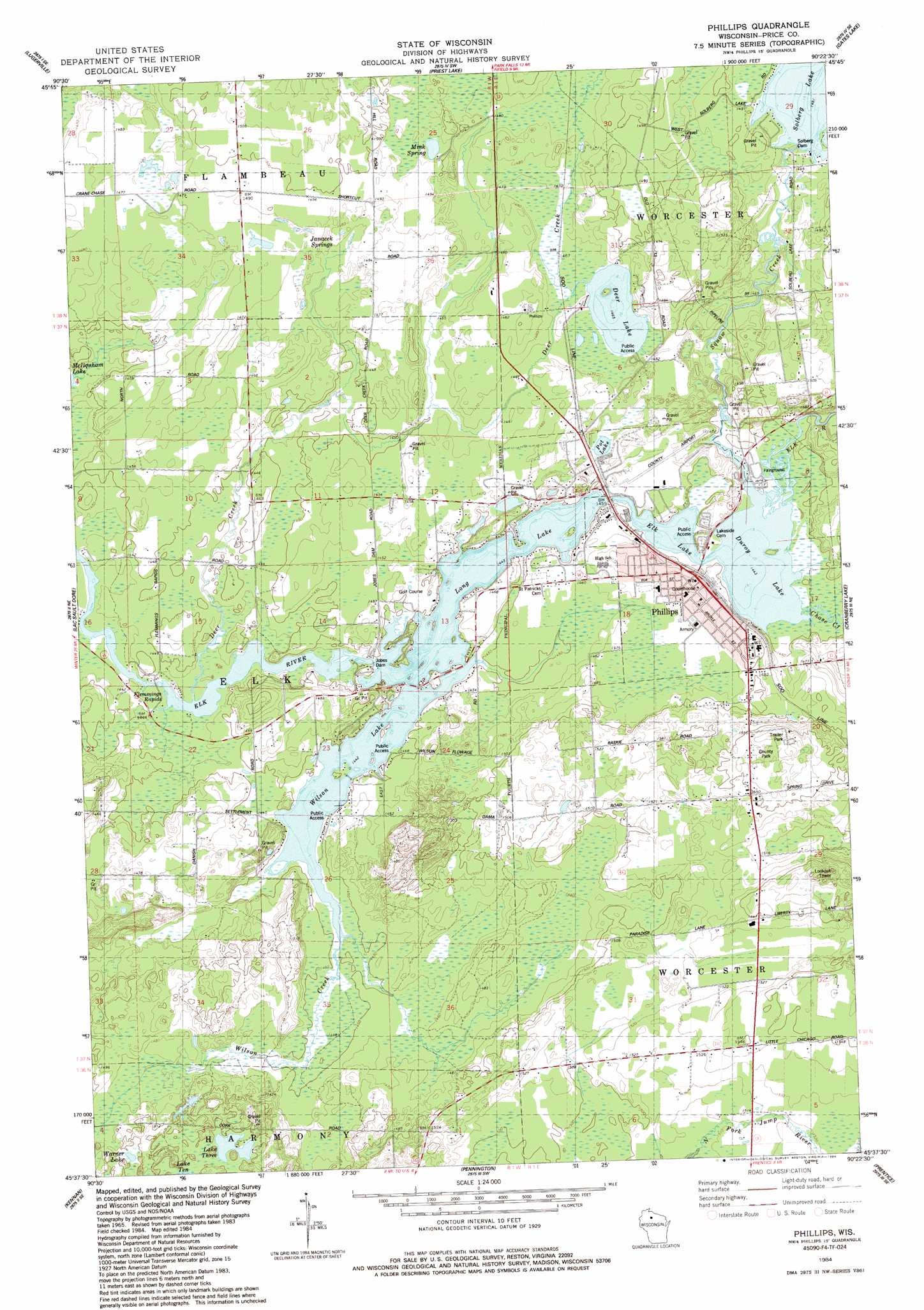
USGS Topo Quad 45090f4 - 1:24,000 scale
| Topo Map Name: | Phillips |
| USGS Topo Quad ID: | 45090f4 |
| Print Size: | ca. 21 1/4" wide x 27" high |
| Southeast Coordinates: | 45.625° N latitude / 90.375° W longitude |
| Map Center Coordinates: | 45.6875° N latitude / 90.4375° W longitude |
| U.S. State: | WI |
| Filename: | o45090f4.jpg |
| Download Map JPG Image: | Phillips topo map 1:24,000 scale |
| Map Type: | Topographic |
| Topo Series: | 7.5´ |
| Map Scale: | 1:24,000 |
| Source of Map Images: | United States Geological Survey (USGS) |
| Alternate Map Versions: |
Phillips WI 1984, updated 1984 Download PDF Buy paper map Phillips WI 2010 Download PDF Buy paper map Phillips WI 2013 Download PDF Buy paper map Phillips WI 2015 Download PDF Buy paper map |
1:24,000 Topo Quads surrounding Phillips
Kennedy |
Butternut Lake |
Park Falls |
Blockhouse Lake |
Pike Lake Nw |
Oxbo |
Lugerville |
Priest Lake |
Gates Lake |
Pike Lake Sw |
Kennan Nw |
Lac Sault Dore |
Phillips |
Cranberry Lake |
Dover |
Hawkins |
Kennan |
Pennington |
Prentice |
Big Briens Lake |
Jump River Fire Tower Nw |
Jump River Fire Tower Ne |
Ogema Nw |
Ogema |
Timms Hill |
> Back to 45090e1 at 1:100,000 scale
> Back to 45090a1 at 1:250,000 scale
> Back to U.S. Topo Maps home
Phillips topo map: Gazetteer
Phillips: Airports
Price County Airport elevation 447m 1466′Phillips: Dams
Cranberry Lake Dam elevation 463m 1519′Jobes 2WP132 Dam elevation 440m 1443′
Jobes Dam elevation 440m 1443′
Solberg 2WP456 Dam elevation 450m 1476′
Solberg Dam elevation 455m 1492′
Phillips: Lakes
Deer Lake elevation 447m 1466′Duroy Lake elevation 440m 1443′
Elk Lake elevation 440m 1443′
Lake Three elevation 455m 1492′
Pot Lake elevation 448m 1469′
Warner Lake elevation 457m 1499′
Wilson Lake elevation 440m 1443′
Phillips: Parks
Price County Fairground elevation 441m 1446′Phillips: Populated Places
Phillips elevation 440m 1443′Phillips: Rapids
Flemmings Rapids elevation 439m 1440′Phillips: Reservoirs
Cranberry Lake elevation 463m 1519′Elk, Duroy, Long Lakes and Wilson Flowage elevation 440m 1443′
Long Lake elevation 437m 1433′
Solberg Lake elevation 453m 1486′
Phillips: Springs
Janacek Springs elevation 451m 1479′Mink Spring elevation 453m 1486′
Phillips: Streams
Chase Creek elevation 440m 1443′Deer Creek elevation 440m 1443′
Squaw Creek elevation 448m 1469′
Wilson Creek elevation 442m 1450′
Phillips digital topo map on disk
Buy this Phillips topo map showing relief, roads, GPS coordinates and other geographical features, as a high-resolution digital map file on DVD: