Lac Sault Dore Topo Map Wisconsin
To zoom in, hover over the map of Lac Sault Dore
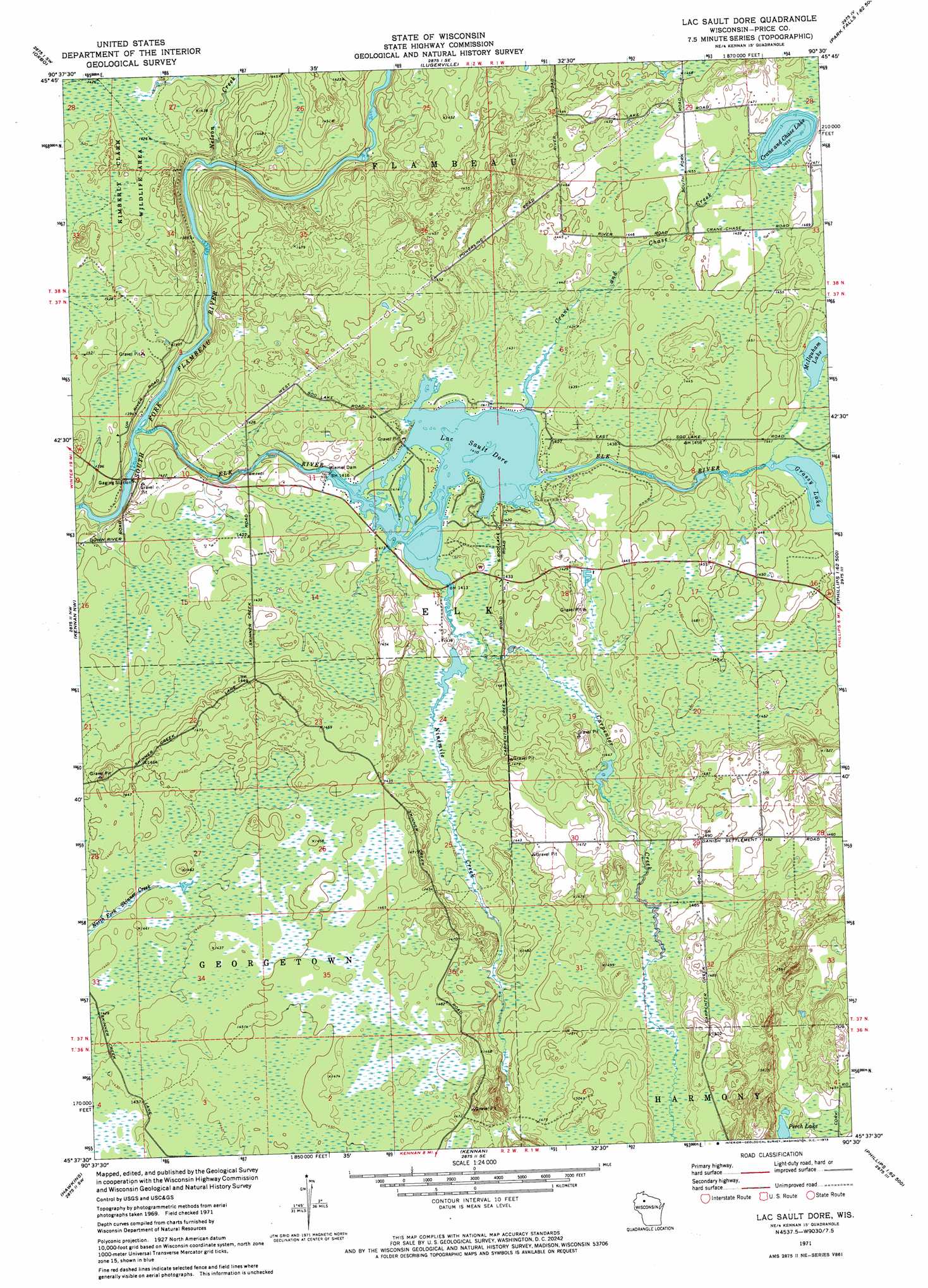
USGS Topo Quad 45090f5 - 1:24,000 scale
| Topo Map Name: | Lac Sault Dore |
| USGS Topo Quad ID: | 45090f5 |
| Print Size: | ca. 21 1/4" wide x 27" high |
| Southeast Coordinates: | 45.625° N latitude / 90.5° W longitude |
| Map Center Coordinates: | 45.6875° N latitude / 90.5625° W longitude |
| U.S. State: | WI |
| Filename: | o45090f5.jpg |
| Download Map JPG Image: | Lac Sault Dore topo map 1:24,000 scale |
| Map Type: | Topographic |
| Topo Series: | 7.5´ |
| Map Scale: | 1:24,000 |
| Source of Map Images: | United States Geological Survey (USGS) |
| Alternate Map Versions: |
Lac Sault Dore WI 1971, updated 1973 Download PDF Buy paper map Lac Sault Dore WI 2010 Download PDF Buy paper map Lac Sault Dore WI 2013 Download PDF Buy paper map Lac Sault Dore WI 2015 Download PDF Buy paper map |
1:24,000 Topo Quads surrounding Lac Sault Dore
Loretta |
Kennedy |
Butternut Lake |
Park Falls |
Blockhouse Lake |
Babbs Island |
Oxbo |
Lugerville |
Priest Lake |
Gates Lake |
Ingram Ne |
Kennan Nw |
Lac Sault Dore |
Phillips |
Cranberry Lake |
Ingram |
Hawkins |
Kennan |
Pennington |
Prentice |
Sheldon Ne |
Jump River Fire Tower Nw |
Jump River Fire Tower Ne |
Ogema Nw |
Ogema |
> Back to 45090e1 at 1:100,000 scale
> Back to 45090a1 at 1:250,000 scale
> Back to U.S. Topo Maps home
Lac Sault Dore topo map: Gazetteer
Lac Sault Dore: Dams
Murray 2WP375 Dam elevation 430m 1410′Wiemer Dam elevation 428m 1404′
Lac Sault Dore: Lakes
Crane and Chase Lake elevation 443m 1453′Grassy Lake elevation 437m 1433′
Lac Sault Dore elevation 429m 1407′
McIlquham Lake elevation 437m 1433′
Perch Lake elevation 452m 1482′
Lac Sault Dore: Reservoirs
Lac Sault Dore 272 elevation 430m 1410′Lac Sault Dore: Streams
Carpenter Creek elevation 431m 1414′Crane and Chase Creek elevation 430m 1410′
Elk River elevation 420m 1377′
Nelson Creek elevation 419m 1374′
Ninemile Creek elevation 429m 1407′
Lac Sault Dore digital topo map on disk
Buy this Lac Sault Dore topo map showing relief, roads, GPS coordinates and other geographical features, as a high-resolution digital map file on DVD: