Pike Lake Sw Topo Map Wisconsin
To zoom in, hover over the map of Pike Lake Sw
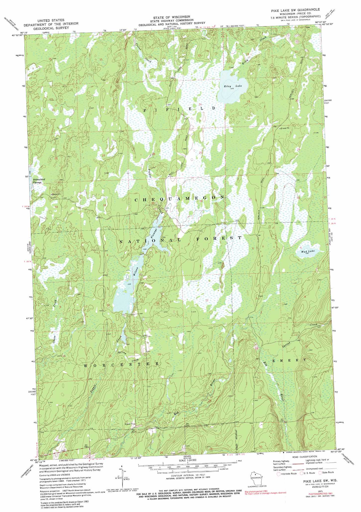
USGS Topo Quad 45090g2 - 1:24,000 scale
| Topo Map Name: | Pike Lake Sw |
| USGS Topo Quad ID: | 45090g2 |
| Print Size: | ca. 21 1/4" wide x 27" high |
| Southeast Coordinates: | 45.75° N latitude / 90.125° W longitude |
| Map Center Coordinates: | 45.8125° N latitude / 90.1875° W longitude |
| U.S. State: | WI |
| Filename: | o45090g2.jpg |
| Download Map JPG Image: | Pike Lake Sw topo map 1:24,000 scale |
| Map Type: | Topographic |
| Topo Series: | 7.5´ |
| Map Scale: | 1:24,000 |
| Source of Map Images: | United States Geological Survey (USGS) |
| Alternate Map Versions: |
Pike Lake SW WI 1971, updated 1973 Download PDF Buy paper map Pike Lake SW WI 1971, updated 1985 Download PDF Buy paper map Pike Lake SW WI 1971, updated 1991 Download PDF Buy paper map Pike Lake SW WI 2005, updated 2006 Download PDF Buy paper map Pike Lake SW WI 2011 Download PDF Buy paper map Pike Lake SW WI 2013 Download PDF Buy paper map Pike Lake SW WI 2015 Download PDF Buy paper map |
| FStopo: | US Forest Service topo Pike Lake SW is available: Download FStopo PDF Download FStopo TIF |
1:24,000 Topo Quads surrounding Pike Lake Sw
Butternut |
Hay Creek Flowage |
Turtle-Flambeau Flowage |
Wilson Lake |
Powell |
Park Falls |
Blockhouse Lake |
Pike Lake Nw |
Pike Lake |
Lac Du Flambeau |
Priest Lake |
Gates Lake |
Pike Lake Sw |
Pike Lake Se |
Lac Du Flambeau Sw |
Phillips |
Cranberry Lake |
Dover |
Thunder Creek |
Pier Lake |
Pennington |
Prentice |
Big Briens Lake |
Brantwood |
Tripoli |
> Back to 45090e1 at 1:100,000 scale
> Back to 45090a1 at 1:250,000 scale
> Back to U.S. Topo Maps home
Pike Lake Sw topo map: Gazetteer
Pike Lake Sw: Lakes
Mud Lake elevation 484m 1587′Riley Lake elevation 479m 1571′
Wilson Flowage elevation 468m 1535′
Pike Lake Sw: Parks
Riley Lake Wildlife Management Area elevation 480m 1574′Pike Lake Sw: Streams
Spring Creek elevation 479m 1571′Spring Creek elevation 464m 1522′
Pike Lake Sw digital topo map on disk
Buy this Pike Lake Sw topo map showing relief, roads, GPS coordinates and other geographical features, as a high-resolution digital map file on DVD: