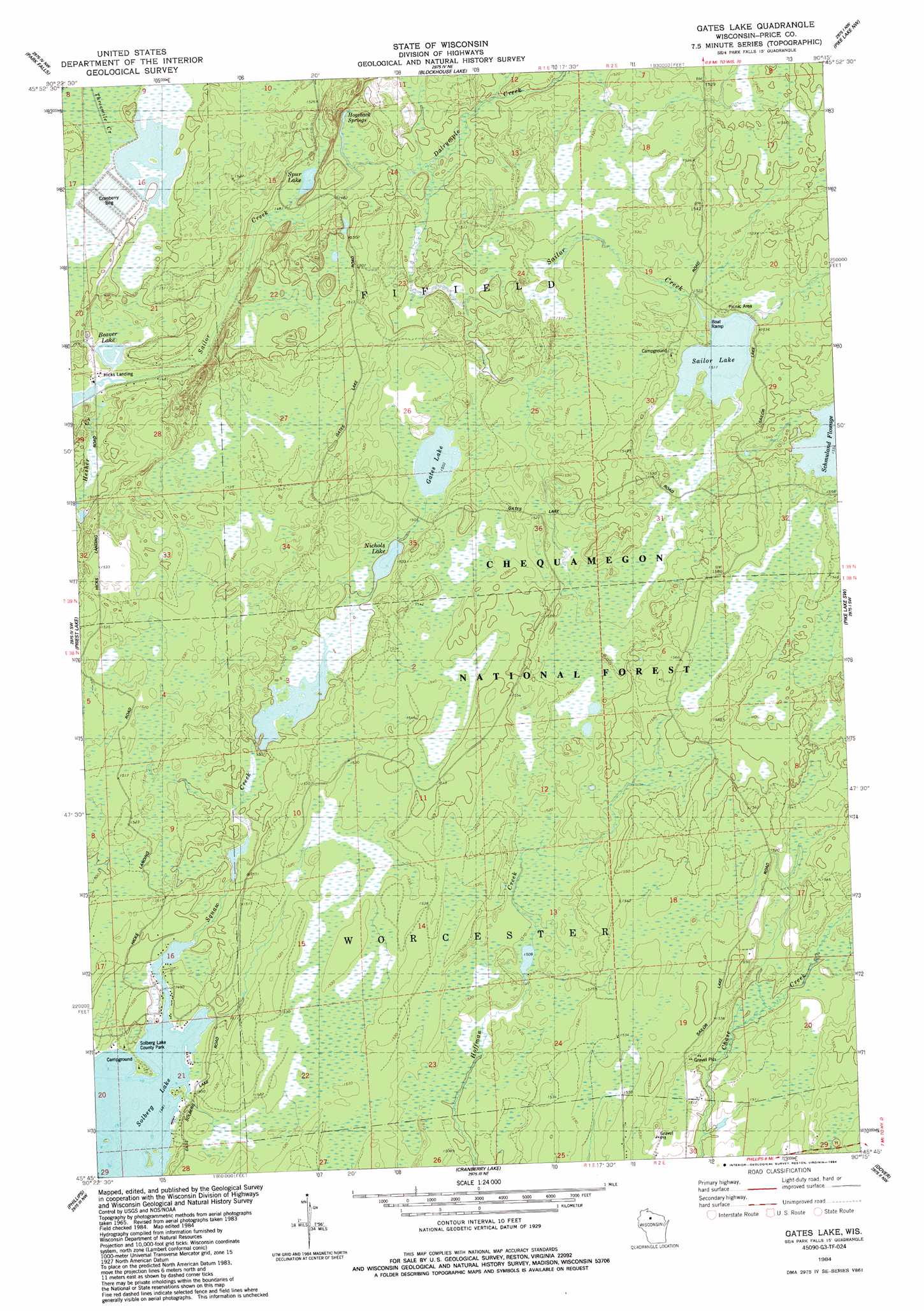
Gates Lake Topo Map Wisconsin
To zoom in, hover over the map of Gates Lake
USGS Topo Quad 45090g3 - 1:24,000 scale
| Topo Map Name: | Gates Lake |
| USGS Topo Quad ID: | 45090g3 |
| Print Size: | ca. 21 1/4" wide x 27" high |
| Southeast Coordinates: | 45.75° N latitude / 90.25° W longitude |
| Map Center Coordinates: | 45.8125° N latitude / 90.3125° W longitude |
| U.S. State: | WI |
| Filename: | o45090g3.jpg |
| Download Map JPG Image: | Gates Lake topo map 1:24,000 scale |
| Map Type: | Topographic |
| Topo Series: | 7.5´ |
| Map Scale: | 1:24,000 |
| Source of Map Images: | United States Geological Survey (USGS) |
| Alternate Map Versions: |
Park Falls SE WI 1968, updated 1985 Download PDF Buy paper map Gates Lake WI 1984, updated 1984 Download PDF Buy paper map Gates Lake WI 2005, updated 2006 Download PDF Buy paper map Gates Lake WI 2011 Download PDF Buy paper map Gates Lake WI 2013 Download PDF Buy paper map Gates Lake WI 2015 Download PDF Buy paper map |
| FStopo: | US Forest Service topo Gates Lake is available: Download FStopo PDF Download FStopo TIF |
1:24,000 Topo Quads surrounding Gates Lake
Peeksville |
Butternut |
Hay Creek Flowage |
Turtle-Flambeau Flowage |
Wilson Lake |
Butternut Lake |
Park Falls |
Blockhouse Lake |
Pike Lake Nw |
Pike Lake |
Lugerville |
Priest Lake |
Gates Lake |
Pike Lake Sw |
Pike Lake Se |
Lac Sault Dore |
Phillips |
Cranberry Lake |
Dover |
Thunder Creek |
Kennan |
Pennington |
Prentice |
Big Briens Lake |
Brantwood |
> Back to 45090e1 at 1:100,000 scale
> Back to 45090a1 at 1:250,000 scale
> Back to U.S. Topo Maps home
Gates Lake topo map: Gazetteer
Gates Lake: Dams
Squaw Creek D31.18 Dam elevation 457m 1499′Squaw Creek Wildlife Flowage 2WP2459 Dam elevation 454m 1489′
Gates Lake: Lakes
Beaver Lake elevation 449m 1473′Gates Lake elevation 458m 1502′
Nichols Lake elevation 456m 1496′
Sailor Lake elevation 462m 1515′
Schmuland Flowage elevation 474m 1555′
Spur Lake elevation 452m 1482′
Gates Lake: Parks
Schmuland Waterfowl Area elevation 474m 1555′Solberg Lake County Park elevation 455m 1492′
Gates Lake: Reservoirs
Lower Squaw Creek Flowage elevation 454m 1489′Squaw Creek Flowage 6 elevation 457m 1499′
Gates Lake: Springs
Hogsback Springs elevation 454m 1489′Gates Lake: Streams
Dalrymple Creek elevation 453m 1486′Hesher Creek elevation 450m 1476′
Gates Lake digital topo map on disk
Buy this Gates Lake topo map showing relief, roads, GPS coordinates and other geographical features, as a high-resolution digital map file on DVD: