Blockhouse Lake Topo Map Wisconsin
To zoom in, hover over the map of Blockhouse Lake
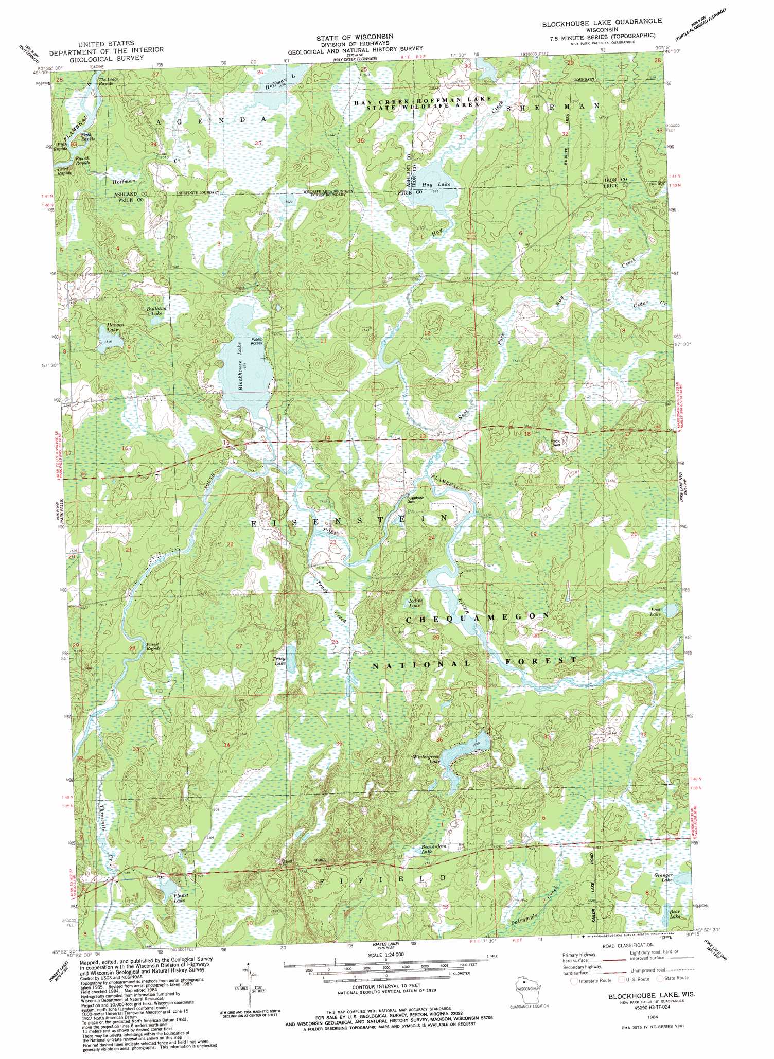
USGS Topo Quad 45090h3 - 1:24,000 scale
| Topo Map Name: | Blockhouse Lake |
| USGS Topo Quad ID: | 45090h3 |
| Print Size: | ca. 21 1/4" wide x 27" high |
| Southeast Coordinates: | 45.875° N latitude / 90.25° W longitude |
| Map Center Coordinates: | 45.9375° N latitude / 90.3125° W longitude |
| U.S. State: | WI |
| Filename: | o45090h3.jpg |
| Download Map JPG Image: | Blockhouse Lake topo map 1:24,000 scale |
| Map Type: | Topographic |
| Topo Series: | 7.5´ |
| Map Scale: | 1:24,000 |
| Source of Map Images: | United States Geological Survey (USGS) |
| Alternate Map Versions: |
Park Falls NE WI 1968, updated 1985 Download PDF Buy paper map Blockhouse Lake WI 1984, updated 1984 Download PDF Buy paper map Blockhouse Lake WI 2005, updated 2006 Download PDF Buy paper map Blockhouse Lake WI 2011 Download PDF Buy paper map Blockhouse Lake WI 2013 Download PDF Buy paper map Blockhouse Lake WI 2015 Download PDF Buy paper map |
| FStopo: | US Forest Service topo Blockhouse Lake is available: Download FStopo PDF Download FStopo TIF |
1:24,000 Topo Quads surrounding Blockhouse Lake
Glidden |
Augustine Lake |
Lake Six |
Lake Of The Falls |
Mercer |
Peeksville |
Butternut |
Hay Creek Flowage |
Turtle-Flambeau Flowage |
Wilson Lake |
Butternut Lake |
Park Falls |
Blockhouse Lake |
Pike Lake Nw |
Pike Lake |
Lugerville |
Priest Lake |
Gates Lake |
Pike Lake Sw |
Pike Lake Se |
Lac Sault Dore |
Phillips |
Cranberry Lake |
Dover |
Thunder Creek |
> Back to 45090e1 at 1:100,000 scale
> Back to 45090a1 at 1:250,000 scale
> Back to U.S. Topo Maps home
Blockhouse Lake topo map: Gazetteer
Blockhouse Lake: Areas
Flambeau Trails Parking Area elevation 471m 1545′Blockhouse Lake: Dams
Sugarbush Dam elevation 460m 1509′Blockhouse Lake: Lakes
Bear Lake elevation 471m 1545′Beaverdam Lake elevation 465m 1525′
Blockhouse Lake elevation 456m 1496′
Bullhead Lake elevation 468m 1535′
Granger Lake elevation 470m 1541′
Hansen Lake elevation 471m 1545′
Hay Lake elevation 465m 1525′
Hoffman Lake elevation 465m 1525′
Iodine Lake elevation 460m 1509′
Lost Lake elevation 465m 1525′
Planet Lake elevation 457m 1499′
Tracy Lake elevation 464m 1522′
Wintergreen Lake elevation 468m 1535′
Blockhouse Lake: Parks
Hay Creek Hoffman Lake State Wildlife Area elevation 475m 1558′Blockhouse Lake: Rapids
Fifth Rapids elevation 455m 1492′Forest Rapids elevation 447m 1466′
Fourth Rapids elevation 455m 1492′
Sixth Rapids elevation 456m 1496′
The Ledge Rapids elevation 458m 1502′
Third Rapids elevation 454m 1489′
Blockhouse Lake: Streams
Cedar Creek elevation 464m 1522′East Fork Hay Creek elevation 461m 1512′
Hay Creek elevation 459m 1505′
Hoffman Creek elevation 457m 1499′
Threemile Creek elevation 448m 1469′
Tracy Creek elevation 456m 1496′
Blockhouse Lake digital topo map on disk
Buy this Blockhouse Lake topo map showing relief, roads, GPS coordinates and other geographical features, as a high-resolution digital map file on DVD: