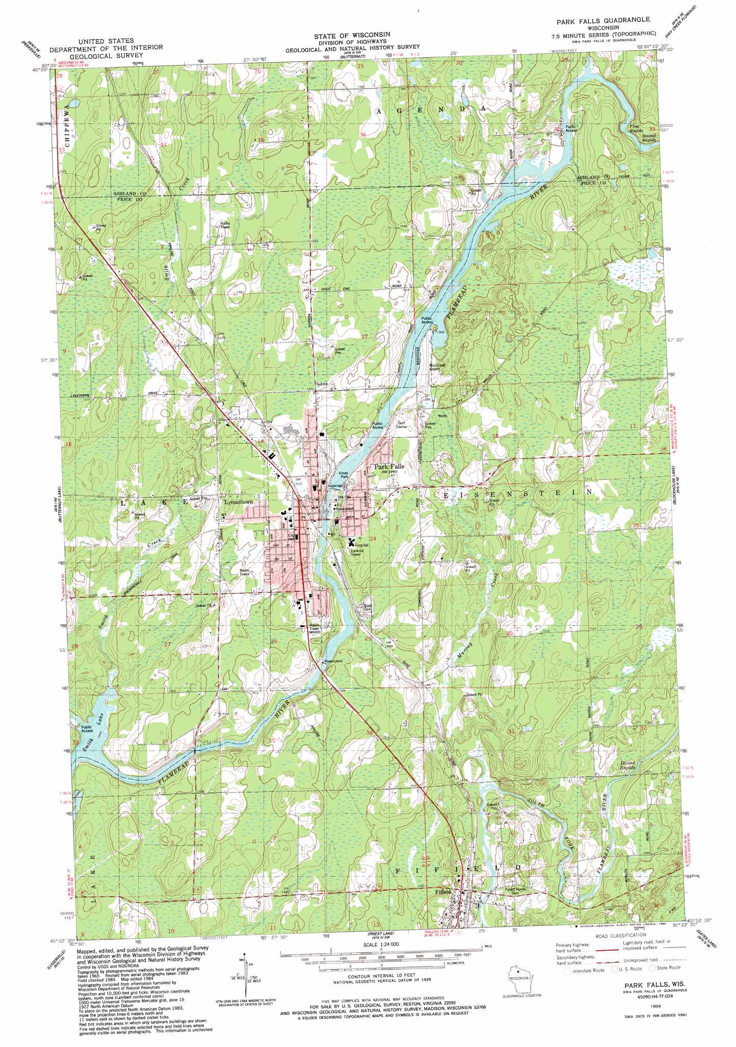
Park Falls Topo Map Wisconsin
To zoom in, hover over the map of Park Falls
USGS Topo Quad 45090h4 - 1:24,000 scale
| Topo Map Name: | Park Falls |
| USGS Topo Quad ID: | 45090h4 |
| Print Size: | ca. 21 1/4" wide x 27" high |
| Southeast Coordinates: | 45.875° N latitude / 90.375° W longitude |
| Map Center Coordinates: | 45.9375° N latitude / 90.4375° W longitude |
| U.S. State: | WI |
| Filename: | o45090h4.jpg |
| Download Map JPG Image: | Park Falls topo map 1:24,000 scale |
| Map Type: | Topographic |
| Topo Series: | 7.5´ |
| Map Scale: | 1:24,000 |
| Source of Map Images: | United States Geological Survey (USGS) |
| Alternate Map Versions: |
Park Falls WI 1984, updated 1984 Download PDF Buy paper map Park Falls WI 2010 Download PDF Buy paper map Park Falls WI 2013 Download PDF Buy paper map Park Falls WI 2015 Download PDF Buy paper map |
1:24,000 Topo Quads surrounding Park Falls
Morse |
Glidden |
Augustine Lake |
Lake Six |
Lake Of The Falls |
Shanagolden |
Peeksville |
Butternut |
Hay Creek Flowage |
Turtle-Flambeau Flowage |
Kennedy |
Butternut Lake |
Park Falls |
Blockhouse Lake |
Pike Lake Nw |
Oxbo |
Lugerville |
Priest Lake |
Gates Lake |
Pike Lake Sw |
Kennan Nw |
Lac Sault Dore |
Phillips |
Cranberry Lake |
Dover |
> Back to 45090e1 at 1:100,000 scale
> Back to 45090a1 at 1:250,000 scale
> Back to U.S. Topo Maps home
Park Falls topo map: Gazetteer
Park Falls: Airports
Park Falls Municipal Airport elevation 455m 1492′Park Falls: Dams
Cummings Dam elevation 439m 1440′Lower Hydro WP183 Dam elevation 446m 1463′
Upper Hydro Dam elevation 452m 1482′
Park Falls: Lakes
Smith Lake elevation 440m 1443′Swamp Lake elevation 475m 1558′
Park Falls: Parks
Hines Park elevation 461m 1512′Triangle Park elevation 454m 1489′
Park Falls: Populated Places
Fifield elevation 454m 1489′Lymantown elevation 462m 1515′
Park Falls elevation 462m 1515′
Park Falls: Post Offices
Park Falls Post Office elevation 457m 1499′Park Falls: Rapids
Divine Rapids elevation 451m 1479′First Rapids elevation 473m 1551′
Second Rapids elevation 452m 1482′
Park Falls: Reservoirs
Lower Park Falls Flowage 762 elevation 446m 1463′Upper Park Falls Flowage 760 elevation 452m 1482′
Park Falls: Streams
Bosner Creek elevation 460m 1509′Murray Creek elevation 438m 1437′
Smith Creek elevation 440m 1443′
Park Falls digital topo map on disk
Buy this Park Falls topo map showing relief, roads, GPS coordinates and other geographical features, as a high-resolution digital map file on DVD: