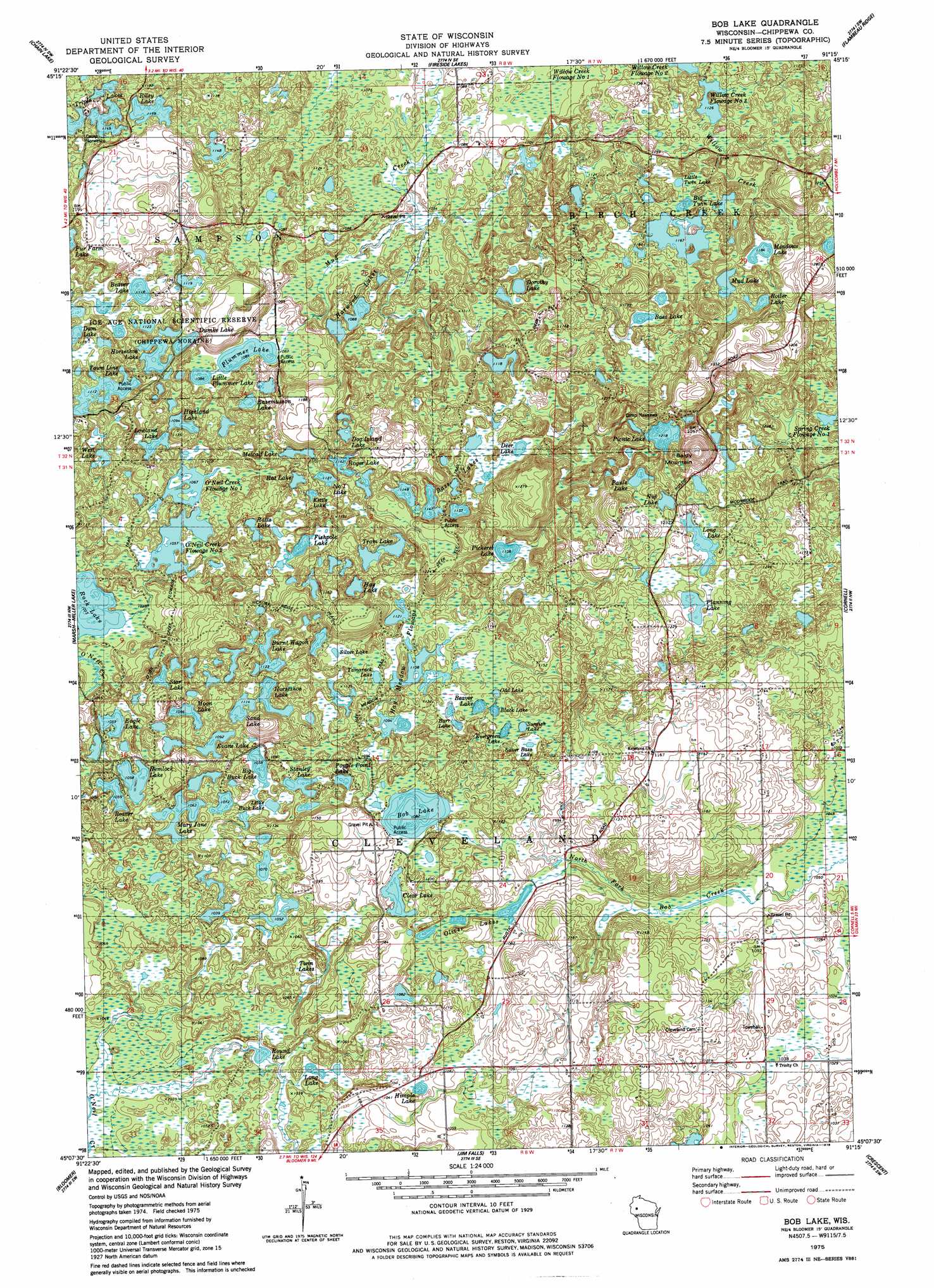
Bob Lake Topo Map Wisconsin
To zoom in, hover over the map of Bob Lake
USGS Topo Quad 45091b3 - 1:24,000 scale
| Topo Map Name: | Bob Lake |
| USGS Topo Quad ID: | 45091b3 |
| Print Size: | ca. 21 1/4" wide x 27" high |
| Southeast Coordinates: | 45.125° N latitude / 91.25° W longitude |
| Map Center Coordinates: | 45.1875° N latitude / 91.3125° W longitude |
| U.S. State: | WI |
| Filename: | o45091b3.jpg |
| Download Map JPG Image: | Bob Lake topo map 1:24,000 scale |
| Map Type: | Topographic |
| Topo Series: | 7.5´ |
| Map Scale: | 1:24,000 |
| Source of Map Images: | United States Geological Survey (USGS) |
| Alternate Map Versions: |
Bob Lake WI 1975, updated 1978 Download PDF Buy paper map Bob Lake WI 2010 Download PDF Buy paper map Bob Lake WI 2013 Download PDF Buy paper map Bob Lake WI 2015 Download PDF Buy paper map |
1:24,000 Topo Quads surrounding Bob Lake
Strickland |
Weyerhauser |
Bruce |
Thornapple |
Ladysmith |
Moose Ear Lake |
Chain Lake |
Fireside Lakes |
Flambeau Ridge |
Ladysmith Se |
New Auburn |
Marsh-Miller Lake |
Bob Lake |
Cornell |
Holcombe |
Como Creek |
Bloomer |
Jim Falls |
Crescent |
Colburn |
Albertville |
Chippewa Falls |
Lake Wissota |
Cadott |
Boyd |
> Back to 45091a1 at 1:100,000 scale
> Back to 45090a1 at 1:250,000 scale
> Back to U.S. Topo Maps home
Bob Lake topo map: Gazetteer
Bob Lake: Dams
Conley E3663 1 Dam elevation 349m 1145′O'Neil Flowage 1 E12.206 Dam elevation 324m 1062′
O'Neil Flowage 2 E12.206 Dam elevation 322m 1056′
Willow Creek Flowage Number 3 E12.52 Dam elevation 345m 1131′
Bob Lake: Lakes
Barr Lake elevation 341m 1118′Bass Lake elevation 360m 1181′
Bass Lakes elevation 350m 1148′
Beaver Lake elevation 341m 1118′
Beaver Lake elevation 341m 1118′
Beaver Lake elevation 323m 1059′
Big Buck Lake elevation 329m 1079′
Big Twin Lake elevation 354m 1161′
Black Lake elevation 341m 1118′
Bob Lake elevation 330m 1082′
Boiler Lake elevation 375m 1230′
Burnt Wagon Lake elevation 342m 1122′
Clear Lake elevation 328m 1076′
Dam Lake elevation 343m 1125′
Deer Lake elevation 347m 1138′
Dog Island Lake elevation 354m 1161′
Dorothy Lake elevation 350m 1148′
Dumke Lake elevation 340m 1115′
Eagle Lake elevation 323m 1059′
Evans Lake elevation 333m 1092′
Evergreen Lake elevation 341m 1118′
Fishpole Lake elevation 337m 1105′
Harwood Lakes elevation 332m 1089′
Hay Lake elevation 347m 1138′
Hay Meadow Flowage elevation 338m 1108′
Hemlock Lake elevation 323m 1059′
Highland Lake elevation 333m 1092′
Himple Lake elevation 322m 1056′
Horseshoe Lake elevation 339m 1112′
Horseshoe Lake elevation 340m 1115′
Kettle Lake elevation 349m 1145′
Little Buck Lake elevation 329m 1079′
Little Plummer Lake elevation 333m 1092′
Little Twin Lake elevation 353m 1158′
Long Lake elevation 311m 1020′
Long Lake elevation 373m 1223′
Lowland Lake elevation 328m 1076′
Mary Jane Lake elevation 324m 1062′
Meadows Lake elevation 361m 1184′
Metcalf Lake elevation 340m 1115′
Moon Lake elevation 334m 1095′
Mud Lake elevation 367m 1204′
Number One Lake elevation 344m 1128′
Nut Lake elevation 374m 1227′
Odd Lake elevation 341m 1118′
Oliver Lakes elevation 326m 1069′
O'Neil Creek Flowage Number One elevation 325m 1066′
Pauls Lake elevation 373m 1223′
Pickerel Lake elevation 347m 1138′
Picnic Lake elevation 371m 1217′
Planning Lake elevation 367m 1204′
Plummer Lake elevation 330m 1082′
Popple Point Lake elevation 333m 1092′
Rassmusson Lake elevation 344m 1128′
Rat Lake elevation 344m 1128′
Rattz Lake elevation 340m 1115′
Riley Lake elevation 353m 1158′
Rock Lake elevation 315m 1033′
Roger Lake elevation 348m 1141′
Round Lake elevation 306m 1003′
Sand Lake elevation 340m 1115′
Silver Bass Lake elevation 344m 1128′
Silver Lake elevation 341m 1118′
Stanley Lake elevation 331m 1085′
Star Lake elevation 331m 1085′
Sunfish Lake elevation 341m 1118′
Tamarack Lake elevation 341m 1118′
Town Line Lake elevation 339m 1112′
Tram Lake elevation 346m 1135′
Triple Lakes elevation 350m 1148′
Twin Lakes elevation 316m 1036′
West Lake elevation 335m 1099′
Bob Lake: Reservoirs
O'Neil Creek Flowage Number Two elevation 322m 1056′O'Neil Flowage 0.2 elevation 324m 1062′
O'Neil Flowage 0.5 elevation 332m 1089′
Spring Creek Flowage Number One elevation 356m 1167′
Willow Creek Flowage 3 elevation 343m 1125′
Willow Creek Flowage Number Three elevation 345m 1131′
Bob Lake: Summits
Baldy Mountain elevation 422m 1384′Bob Lake: Trails
Deer Fly Trail elevation 369m 1210′Hay Meadow Trail elevation 344m 1128′
Hickory Ridge Trail elevation 366m 1200′
O'Neil Creek Flowage Trail elevation 332m 1089′
Bob Lake digital topo map on disk
Buy this Bob Lake topo map showing relief, roads, GPS coordinates and other geographical features, as a high-resolution digital map file on DVD: