Ladysmith Topo Map Wisconsin
To zoom in, hover over the map of Ladysmith
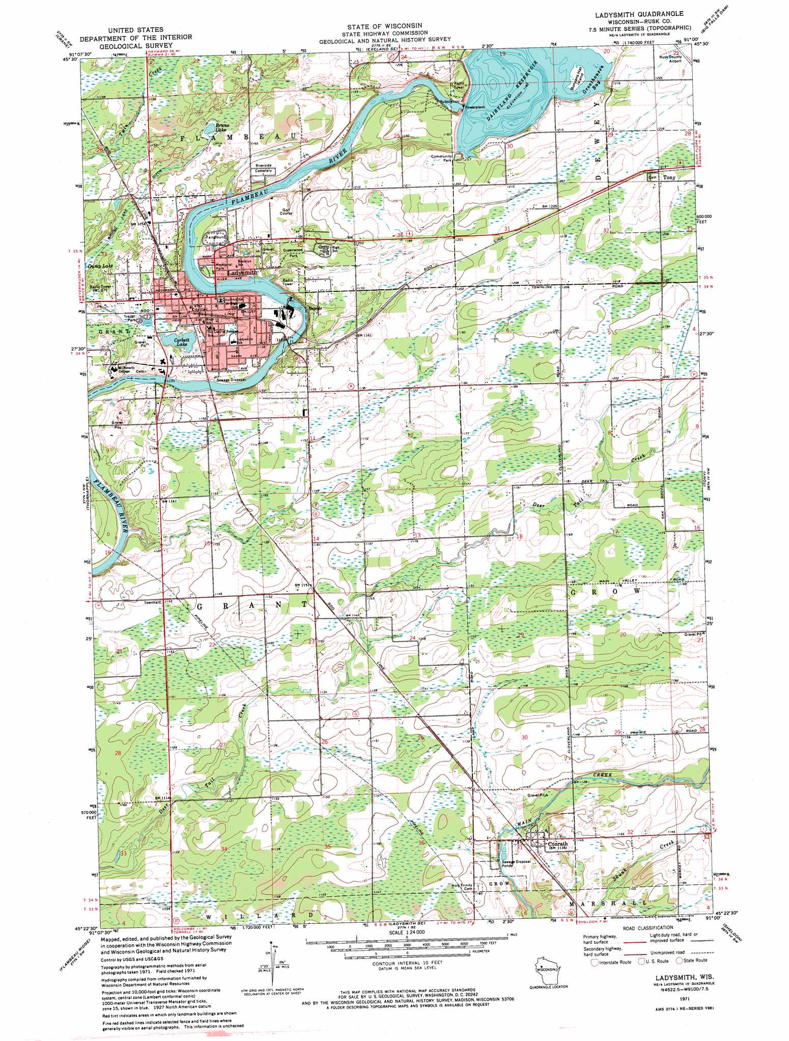
USGS Topo Quad 45091d1 - 1:24,000 scale
| Topo Map Name: | Ladysmith |
| USGS Topo Quad ID: | 45091d1 |
| Print Size: | ca. 21 1/4" wide x 27" high |
| Southeast Coordinates: | 45.375° N latitude / 91° W longitude |
| Map Center Coordinates: | 45.4375° N latitude / 91.0625° W longitude |
| U.S. State: | WI |
| Filename: | o45091d1.jpg |
| Download Map JPG Image: | Ladysmith topo map 1:24,000 scale |
| Map Type: | Topographic |
| Topo Series: | 7.5´ |
| Map Scale: | 1:24,000 |
| Source of Map Images: | United States Geological Survey (USGS) |
| Alternate Map Versions: |
Ladysmith WI 1971, updated 1973 Download PDF Buy paper map Ladysmith WI 2010 Download PDF Buy paper map Ladysmith WI 2013 Download PDF Buy paper map Ladysmith WI 2015 Download PDF Buy paper map |
1:24,000 Topo Quads surrounding Ladysmith
Weirgor |
Exeland |
Hogsback Creek |
Ingram Nw |
Ingram Ne |
Becky Creek |
Crane |
Exeland Se |
Big Falls Dam |
Ingram |
Bruce |
Thornapple |
Ladysmith |
Tony |
Sheldon Ne |
Fireside Lakes |
Flambeau Ridge |
Ladysmith Se |
Sheldon |
Jump River |
Bob Lake |
Cornell |
Holcombe |
Ruby |
Gilman |
> Back to 45091a1 at 1:100,000 scale
> Back to 45090a1 at 1:250,000 scale
> Back to U.S. Topo Maps home
Ladysmith topo map: Gazetteer
Ladysmith: Airports
Rusk County Airport elevation 376m 1233′Rusk County Memorial Heliport elevation 338m 1108′
Ladysmith: Bays
Groothousen Bay elevation 360m 1181′Ladysmith: Canals
Bruno Lake Ditch elevation 351m 1151′Ladysmith: Dams
Flambeau 2WP683 Dam elevation 360m 1181′Ladysmith 1901c455 Dam elevation 339m 1112′
Ladysmith: Islands
Bunyans Hat Island elevation 361m 1184′Ladysmith: Lakes
Bruno Lake elevation 350m 1148′Corbett Lake elevation 342m 1122′
Ladysmith: Parks
Greenwood Park elevation 355m 1164′Memorial Park elevation 343m 1125′
O J Falge Park elevation 344m 1128′
Ladysmith: Populated Places
Conrath elevation 346m 1135′Highway Eight Trailer Court elevation 347m 1138′
Ladysmith elevation 349m 1145′
Willow Lane Trailer Park elevation 351m 1151′
Ladysmith: Post Offices
Ladysmith Post Office elevation 349m 1145′Ladysmith: Reservoirs
Dairyland Reservoir elevation 360m 1181′Ladysmith Flowage 1940 elevation 339m 1112′
Ladysmith digital topo map on disk
Buy this Ladysmith topo map showing relief, roads, GPS coordinates and other geographical features, as a high-resolution digital map file on DVD: