Sarona Topo Map Wisconsin
To zoom in, hover over the map of Sarona
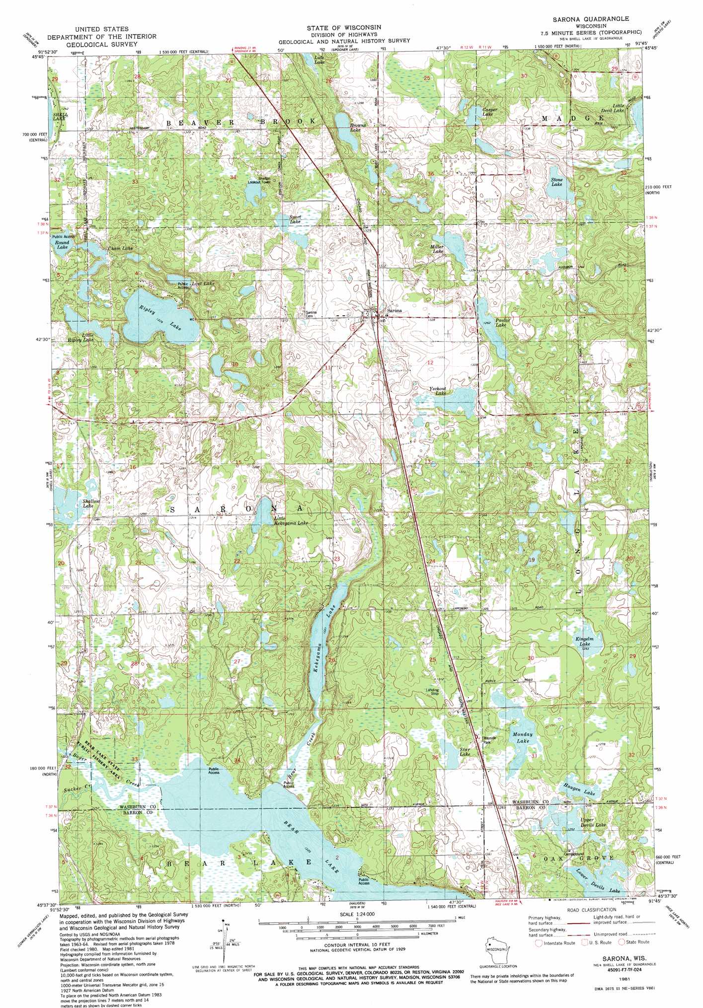
USGS Topo Quad 45091f7 - 1:24,000 scale
| Topo Map Name: | Sarona |
| USGS Topo Quad ID: | 45091f7 |
| Print Size: | ca. 21 1/4" wide x 27" high |
| Southeast Coordinates: | 45.625° N latitude / 91.75° W longitude |
| Map Center Coordinates: | 45.6875° N latitude / 91.8125° W longitude |
| U.S. State: | WI |
| Filename: | o45091f7.jpg |
| Download Map JPG Image: | Sarona topo map 1:24,000 scale |
| Map Type: | Topographic |
| Topo Series: | 7.5´ |
| Map Scale: | 1:24,000 |
| Source of Map Images: | United States Geological Survey (USGS) |
| Alternate Map Versions: |
Sarona WI 1981, updated 1982 Download PDF Buy paper map Sarona WI 1981, updated 1986 Download PDF Buy paper map Sarona WI 2010 Download PDF Buy paper map Sarona WI 2013 Download PDF Buy paper map Sarona WI 2015 Download PDF Buy paper map |
1:24,000 Topo Quads surrounding Sarona
Mckenzie Lake |
Dunn Lake |
Trego |
Springbrook |
Bean Lake |
Poquettes Lake |
Spooner |
Spooner Lake |
Potato Lake |
Stone Lake |
Timberland |
Shell Lake |
Sarona |
Nobleton |
Birchwood |
Cumberland |
Lower Vermillion Lake |
Haugen |
Rice Lake North |
Mikana |
Almenia |
Poskin |
Barron |
Rice Lake South |
Strickland |
> Back to 45091e1 at 1:100,000 scale
> Back to 45090a1 at 1:250,000 scale
> Back to U.S. Topo Maps home
Sarona topo map: Gazetteer
Sarona: Airports
Four Seasons Airport elevation 393m 1289′Sarona: Lakes
Bear Lake elevation 372m 1220′Browns Lake elevation 373m 1223′
Casper Lake elevation 376m 1233′
Chain Lake elevation 373m 1223′
Haugen Lake elevation 382m 1253′
Kekegama Lake elevation 373m 1223′
Kingelm Lake elevation 394m 1292′
Little Devil Lake elevation 373m 1223′
Little Kekegama Lake elevation 385m 1263′
Little Ripley Lake elevation 376m 1233′
Lost Lake elevation 373m 1223′
Lower Devils Lake elevation 382m 1253′
Miller Lake elevation 382m 1253′
Monday Lake elevation 385m 1263′
Pavlas Lake elevation 385m 1263′
Ripley Lake elevation 373m 1223′
Round Lake elevation 373m 1223′
Shallow Lake elevation 388m 1272′
Sport Lake elevation 397m 1302′
Star Lake elevation 391m 1282′
Stone Lake elevation 376m 1233′
Upper Devils Lake elevation 382m 1253′
Yechout Lake elevation 392m 1286′
Sarona: Parks
Bear Lake State Public Fishery Area elevation 374m 1227′Sarona: Populated Places
Sarona elevation 396m 1299′Sarona: Post Offices
Sarona Post Office elevation 395m 1295′Sarona: Streams
Bear Creek elevation 372m 1220′Boyer Creek elevation 372m 1220′
Sucker Creek elevation 387m 1269′
Sarona digital topo map on disk
Buy this Sarona topo map showing relief, roads, GPS coordinates and other geographical features, as a high-resolution digital map file on DVD: