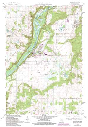
Osceola Topo Map Wisconsin
To zoom in, hover over the map of Osceola
USGS Topo Quad 45092c6 - 1:24,000 scale
| Topo Map Name: | Osceola |
| USGS Topo Quad ID: | 45092c6 |
| Print Size: | ca. 21 1/4" wide x 27" high |
| Southeast Coordinates: | 45.25° N latitude / 92.625° W longitude |
| Map Center Coordinates: | 45.3125° N latitude / 92.6875° W longitude |
| U.S. States: | WI, MN |
| Filename: | o45092c6.jpg |
| Download Map JPG Image: | Osceola topo map 1:24,000 scale |
| Map Type: | Topographic |
| Topo Series: | 7.5´ |
| Map Scale: | 1:24,000 |
| Source of Map Images: | United States Geological Survey (USGS) |
| Alternate Map Versions: |
St. Croix Dalles SW WI 1974, updated 1976 Download PDF Buy paper map Osceola WI 1978, updated 1979 Download PDF Buy paper map Osceola WI 1978, updated 1979 Download PDF Buy paper map Osceola WI 1978, updated 1993 Download PDF Buy paper map Osceola WI 2010 Download PDF Buy paper map Osceola WI 2013 Download PDF Buy paper map Osceola WI 2015 Download PDF Buy paper map |
1:24,000 Topo Quads surrounding Osceola
> Back to 45092a1 at 1:100,000 scale
> Back to 45092a1 at 1:250,000 scale
> Back to U.S. Topo Maps home
Osceola topo map: Gazetteer
Osceola: Airports
Kroy-Osceola Heliport elevation 265m 869′L O Simenstad Municipal Airport elevation 271m 889′
Osceola Municipal Airfield elevation 273m 895′
Osceola: Guts
Close Slu elevation 210m 688′Osceola: Islands
Rock Island elevation 208m 682′Osceola: Lakes
Folsom Lake elevation 213m 698′Hawkinson Lake elevation 275m 902′
Johnson Lake elevation 272m 892′
Lower Lake elevation 209m 685′
Osceola Lake elevation 272m 892′
Peaslee Lake elevation 208m 682′
Rice Lake elevation 208m 682′
Osceola: Parks
Four-H Park elevation 274m 898′Osceola Bedrock Glades State Natural Area elevation 267m 875′
Osceola: Populated Places
Dresser elevation 283m 928′East Farmington elevation 317m 1040′
Franconia elevation 215m 705′
Osceola elevation 248m 813′
Osceola: Post Offices
Franconia Post Office (historical) elevation 214m 702′Osceola: Streams
Lawrence Creek elevation 208m 682′Osceola Creek elevation 211m 692′
Osceola digital topo map on disk
Buy this Osceola topo map showing relief, roads, GPS coordinates and other geographical features, as a high-resolution digital map file on DVD:


