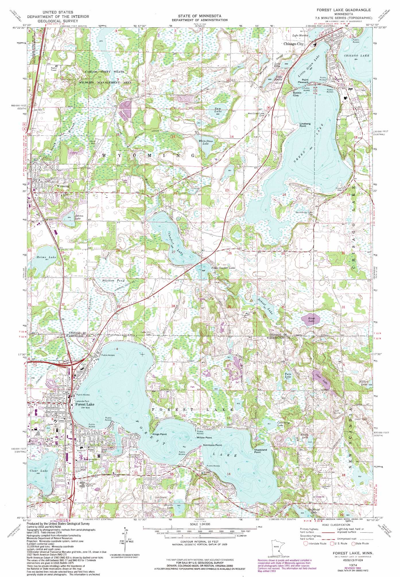
Forest Lake Topo Map Minnesota
To zoom in, hover over the map of Forest Lake
USGS Topo Quad 45092c8 - 1:24,000 scale
| Topo Map Name: | Forest Lake |
| USGS Topo Quad ID: | 45092c8 |
| Print Size: | ca. 21 1/4" wide x 27" high |
| Southeast Coordinates: | 45.25° N latitude / 92.875° W longitude |
| Map Center Coordinates: | 45.3125° N latitude / 92.9375° W longitude |
| U.S. State: | MN |
| Filename: | o45092c8.jpg |
| Download Map JPG Image: | Forest Lake topo map 1:24,000 scale |
| Map Type: | Topographic |
| Topo Series: | 7.5´ |
| Map Scale: | 1:24,000 |
| Source of Map Images: | United States Geological Survey (USGS) |
| Alternate Map Versions: |
Forest Lake MN 1974, updated 1976 Download PDF Buy paper map Forest Lake MN 1974, updated 1993 Download PDF Buy paper map Forest Lake MN 2010 Download PDF Buy paper map Forest Lake MN 2013 Download PDF Buy paper map Forest Lake MN 2016 Download PDF Buy paper map |
1:24,000 Topo Quads surrounding Forest Lake
Cambridge |
Stark |
North Branch |
Sunrise |
Cushing |
Isanti |
Typo Lake |
Stacy |
Lindstrom |
Saint Croix Dalles |
Coon Lake Beach |
Linwood |
Forest Lake |
Scandia |
Osceola |
Circle Pines |
Centerville |
Hugo |
Marine On Saint Croix |
Somerset North |
New Brighton |
White Bear Lake West |
White Bear Lake East |
Stillwater |
Somerset South |
> Back to 45092a1 at 1:100,000 scale
> Back to 45092a1 at 1:250,000 scale
> Back to U.S. Topo Maps home
Forest Lake topo map: Gazetteer
Forest Lake: Airports
Dupres Airport elevation 284m 931′Waldref Seaplane Base elevation 277m 908′
Forest Lake: Canals
Judicial Ditch Number One elevation 272m 892′Judicial Ditch Number Two elevation 274m 898′
Forest Lake: Capes
Kings Point elevation 277m 908′Lindberg Point elevation 271m 889′
Point Pleasant elevation 275m 902′
Shadyland Point elevation 277m 908′
Simmons Point elevation 276m 905′
Willow Point elevation 276m 905′
Forest Lake: Channels
Lighthouse Assembly of God Church elevation 287m 941′Forest Lake: Islands
Allina Medical Clinic - Forest Lake elevation 278m 912′Forest Lake: Lakes
Ashton Lake elevation 272m 892′Birch Lake elevation 272m 892′
Clear Lake elevation 275m 902′
Comfort Lake elevation 269m 882′
Cranberry Lake elevation 275m 902′
Elwell Lake elevation 278m 912′
Forest Lake elevation 275m 902′
Green Lake elevation 269m 882′
Heims Lake elevation 275m 902′
Lake Ellen elevation 269m 882′
Lake Emily elevation 269m 882′
Lake Martha elevation 275m 902′
Little Comfort Lake elevation 269m 882′
Little Green Lake elevation 269m 882′
Sam Lake elevation 269m 882′
School Lake elevation 272m 892′
Shields Lake elevation 275m 902′
Twin Lake elevation 278m 912′
White Stone Lake elevation 272m 892′
Forest Lake: Parks
Bayview Estates Park elevation 286m 938′Beltz Park elevation 282m 925′
Bixby Park elevation 274m 898′
Cedar Park elevation 276m 905′
Clear Lake Park elevation 269m 882′
Kulencamp Park elevation 285m 935′
Lakeside Park elevation 277m 908′
Little Green Park elevation 272m 892′
North Shore Circle Park elevation 277m 908′
Schilling Park elevation 276m 905′
Sherwood Park elevation 278m 912′
Southview Park elevation 283m 928′
Tolzman Park elevation 277m 908′
Tower Park elevation 277m 908′
Forest Lake: Populated Places
Birchwood Terrace Mobile Home Park elevation 277m 908′Bonnie Glen elevation 274m 898′
Chisago City elevation 282m 925′
Croix Estates elevation 276m 905′
Forest Lake elevation 278m 912′
River Bend Mobile Home Park elevation 273m 895′
Woodland Mobile Home Park elevation 278m 912′
Wyoming elevation 276m 905′
Forest Lake: Post Offices
Chisago City Post Office elevation 280m 918′Forest Lake Post Office elevation 278m 912′
Wyoming Post Office elevation 275m 902′
Forest Lake: Streams
South Branch Sunrise River elevation 266m 872′Forest Lake: Swamps
Shallow Pond elevation 272m 892′Forest Lake digital topo map on disk
Buy this Forest Lake topo map showing relief, roads, GPS coordinates and other geographical features, as a high-resolution digital map file on DVD: