Trade Lake Topo Map Wisconsin
To zoom in, hover over the map of Trade Lake
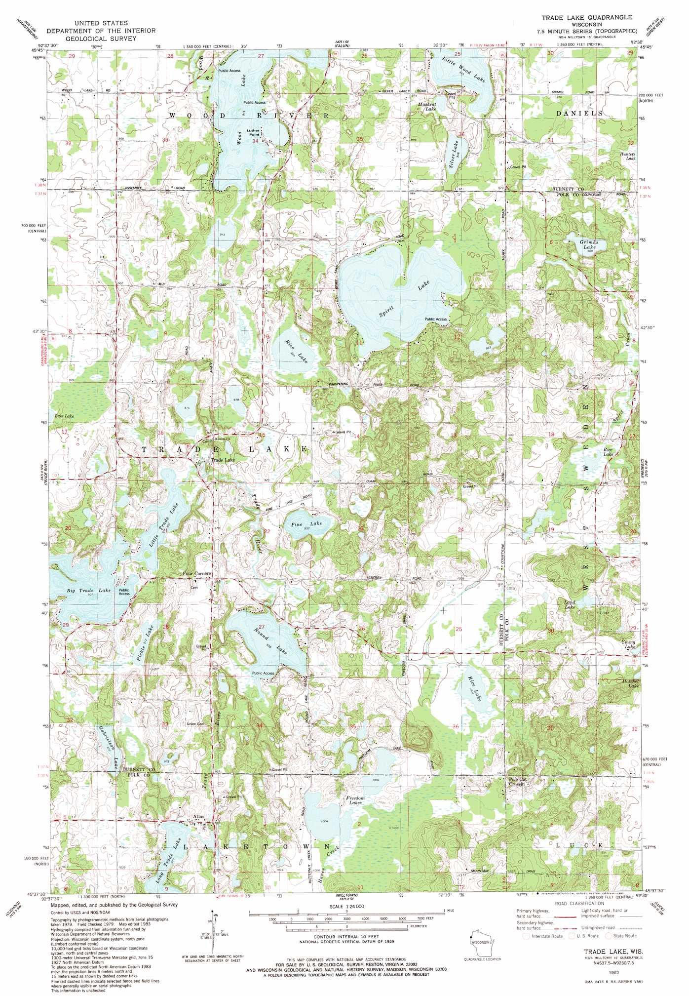
USGS Topo Quad 45092f5 - 1:24,000 scale
| Topo Map Name: | Trade Lake |
| USGS Topo Quad ID: | 45092f5 |
| Print Size: | ca. 21 1/4" wide x 27" high |
| Southeast Coordinates: | 45.625° N latitude / 92.5° W longitude |
| Map Center Coordinates: | 45.6875° N latitude / 92.5625° W longitude |
| U.S. State: | WI |
| Filename: | o45092f5.jpg |
| Download Map JPG Image: | Trade Lake topo map 1:24,000 scale |
| Map Type: | Topographic |
| Topo Series: | 7.5´ |
| Map Scale: | 1:24,000 |
| Source of Map Images: | United States Geological Survey (USGS) |
| Alternate Map Versions: |
Milltown NE WI 1974, updated 1976 Download PDF Buy paper map Trade Lake WI 1983, updated 1983 Download PDF Buy paper map Trade Lake WI 2010 Download PDF Buy paper map Trade Lake WI 2013 Download PDF Buy paper map Trade Lake WI 2015 Download PDF Buy paper map |
1:24,000 Topo Quads surrounding Trade Lake
Cedar Lake |
Lake Clayton |
Saint Johns Landing |
Yellow Lake |
Webster |
Bass Creek |
Grantsburg |
Falun |
Siren West |
Siren East |
Randall |
Trade River |
Trade Lake |
Frederic |
Clam Falls |
Sunrise |
Cushing |
Milltown |
Luck |
Big Round Lake |
Lindstrom |
Saint Croix Dalles |
Centuria |
Balsam Lake |
Range |
> Back to 45092e1 at 1:100,000 scale
> Back to 45092a1 at 1:250,000 scale
> Back to U.S. Topo Maps home
Trade Lake topo map: Gazetteer
Trade Lake: Dams
Atlas Feed Mill Mill Dam elevation 301m 987′Trade Lake: Lakes
Big Trade Lake elevation 275m 902′Freedom Lakes elevation 305m 1000′
Gabrielson Lake elevation 296m 971′
Grimhs Lake elevation 293m 961′
Land Lake elevation 321m 1053′
Little Trade Lake elevation 275m 902′
Little Wood Lake elevation 284m 931′
Long Trade Lake elevation 296m 971′
Muskrat Lake elevation 288m 944′
Pickle Lake elevation 278m 912′
Pine Lake elevation 285m 935′
Rice Lake elevation 281m 921′
Rice Lake elevation 305m 1000′
Rice Lake elevation 299m 980′
Round Lake elevation 281m 921′
Silver Lake elevation 287m 941′
Spirit Lake elevation 287m 941′
Wood Lake elevation 278m 912′
Trade Lake: Populated Places
Atlas elevation 299m 980′Four Corners elevation 307m 1007′
Pole Cat Crossing elevation 319m 1046′
Trade Lake elevation 279m 915′
Trade Lake: Reservoirs
Long Trade Lake 45 elevation 301m 987′Trade Lake: Streams
Spirit Creek elevation 287m 941′Trade Lake digital topo map on disk
Buy this Trade Lake topo map showing relief, roads, GPS coordinates and other geographical features, as a high-resolution digital map file on DVD: