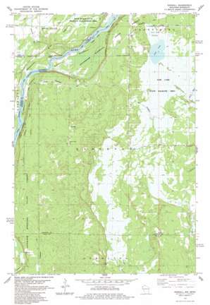
Randall Topo Map Wisconsin
To zoom in, hover over the map of Randall
USGS Topo Quad 45092f7 - 1:24,000 scale
| Topo Map Name: | Randall |
| USGS Topo Quad ID: | 45092f7 |
| Print Size: | ca. 21 1/4" wide x 27" high |
| Southeast Coordinates: | 45.625° N latitude / 92.75° W longitude |
| Map Center Coordinates: | 45.6875° N latitude / 92.8125° W longitude |
| U.S. States: | WI, MN |
| Filename: | o45092f7.jpg |
| Download Map JPG Image: | Randall topo map 1:24,000 scale |
| Map Type: | Topographic |
| Topo Series: | 7.5´ |
| Map Scale: | 1:24,000 |
| Source of Map Images: | United States Geological Survey (USGS) |
| Alternate Map Versions: |
Randall WI 1983, updated 1984 Download PDF Buy paper map Randall WI 2010 Download PDF Buy paper map Randall WI 2013 Download PDF Buy paper map Randall WI 2015 Download PDF Buy paper map |
1:24,000 Topo Quads surrounding Randall
> Back to 45092e1 at 1:100,000 scale
> Back to 45092a1 at 1:250,000 scale
> Back to U.S. Topo Maps home
Randall topo map: Gazetteer
Randall: Dams
Fish Lake County Highway O H12.152 Dam elevation 272m 892′Randall: Lakes
Fish Lake elevation 271m 889′Randall: Parks
Fish Lake Meadow State Natural Area elevation 273m 895′Rock Marsh State Wildlife Management Area elevation 263m 862′
Saint Croix Ash Swamp State Natural Area elevation 243m 797′
Saint Croix National Scenic River elevation 236m 774′
Saint Croix Seeps State Natural Area elevation 250m 820′
Randall: Populated Places
Benson elevation 267m 875′Lind elevation 274m 898′
Randall elevation 273m 895′
Randall: Reservoirs
County Trunk O Flowage elevation 272m 892′Town Road Flowage elevation 273m 895′
Randall: Streams
Cold Creek elevation 259m 849′Rock Creek elevation 237m 777′
Stevens Creek elevation 237m 777′
Randall digital topo map on disk
Buy this Randall topo map showing relief, roads, GPS coordinates and other geographical features, as a high-resolution digital map file on DVD:


