White Bear Lake West Topo Map Minnesota
To zoom in, hover over the map of White Bear Lake West
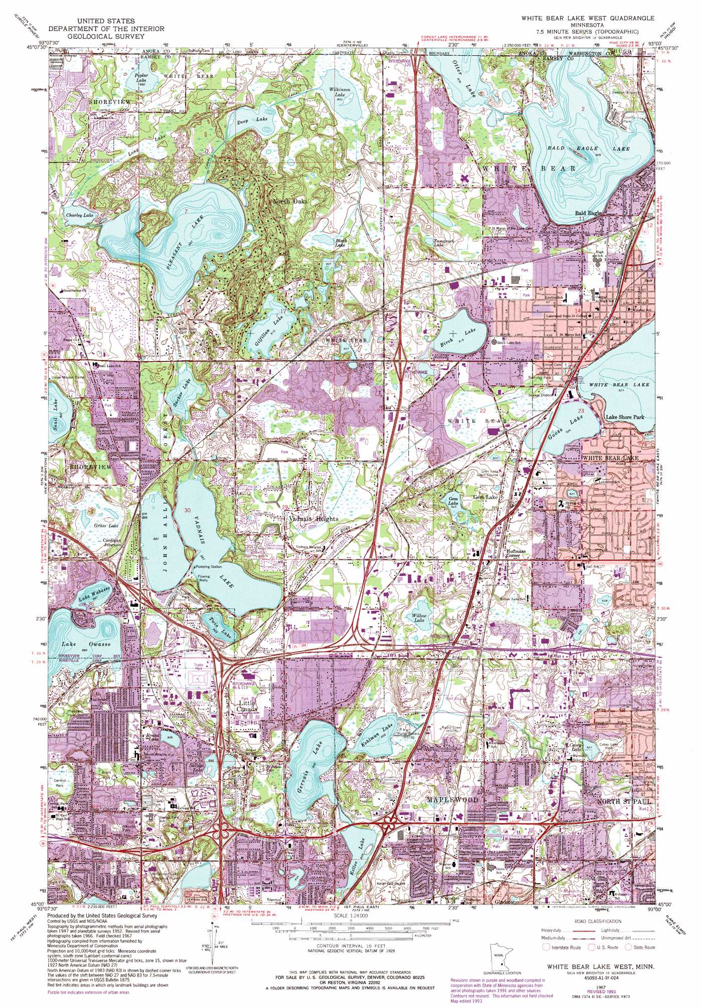
USGS Topo Quad 45093a1 - 1:24,000 scale
| Topo Map Name: | White Bear Lake West |
| USGS Topo Quad ID: | 45093a1 |
| Print Size: | ca. 21 1/4" wide x 27" high |
| Southeast Coordinates: | 45° N latitude / 93° W longitude |
| Map Center Coordinates: | 45.0625° N latitude / 93.0625° W longitude |
| U.S. State: | MN |
| Filename: | o45093a1.jpg |
| Download Map JPG Image: | White Bear Lake West topo map 1:24,000 scale |
| Map Type: | Topographic |
| Topo Series: | 7.5´ |
| Map Scale: | 1:24,000 |
| Source of Map Images: | United States Geological Survey (USGS) |
| Alternate Map Versions: |
White Bear Lake West MN 1952, updated 1954 Download PDF Buy paper map White Bear Lake West MN 1952, updated 1965 Download PDF Buy paper map White Bear Lake West MN 1967, updated 1969 Download PDF Buy paper map White Bear Lake West MN 1967, updated 1973 Download PDF Buy paper map White Bear Lake West MN 1967, updated 1981 Download PDF Buy paper map White Bear Lake West MN 1967, updated 1987 Download PDF Buy paper map White Bear Lake West MN 1967, updated 1993 Download PDF Buy paper map White Bear Lake West MN 2010 Download PDF Buy paper map White Bear Lake West MN 2013 Download PDF Buy paper map White Bear Lake West MN 2016 Download PDF Buy paper map |
1:24,000 Topo Quads surrounding White Bear Lake West
Cedar |
Coon Lake Beach |
Linwood |
Forest Lake |
Scandia |
Coon Rapids |
Circle Pines |
Centerville |
Hugo |
Marine On Saint Croix |
Minneapolis North |
New Brighton |
White Bear Lake West |
White Bear Lake East |
Stillwater |
Minneapolis South |
Saint Paul West |
Saint Paul East |
Lake Elmo |
Hudson |
Bloomington |
Saint Paul Sw |
Inver Grove Heights |
Saint Paul Park |
Prescott |
> Back to 45093a1 at 1:100,000 scale
> Back to 45092a1 at 1:250,000 scale
> Back to U.S. Topo Maps home
White Bear Lake West topo map: Gazetteer
White Bear Lake West: Airports
Bald Eagle Seaplane Base elevation 277m 908′White Bear Lake West: Crossings
Interchange 111A and 111B elevation 278m 912′Interchange 112 elevation 276m 905′
Interchange 114 elevation 274m 898′
Interchange 117 elevation 282m 925′
Interchange 45 elevation 277m 908′
Interchange 46 elevation 269m 882′
Interchange 47 elevation 281m 921′
Interchange 48 elevation 274m 898′
Interchange 50 elevation 288m 944′
White Bear Lake West: Forests
John H Allison Forest elevation 282m 925′White Bear Lake West: Lakes
Bald Eagle Lake elevation 277m 908′Birch Lake elevation 280m 918′
Black Lake elevation 273m 895′
Casey Lake elevation 283m 928′
Charley Lake elevation 273m 895′
Deep Lake elevation 273m 895′
Gem Lake elevation 288m 944′
Gervais Lake elevation 262m 859′
Gilfillan Lake elevation 278m 912′
Goose Lake elevation 282m 925′
Keller Lake elevation 262m 859′
Kohlman Lake elevation 262m 859′
Lake Owasso elevation 270m 885′
Lake Wabasso elevation 270m 885′
Markham Pond elevation 266m 872′
Otter Lake elevation 276m 905′
Pleasant Lake elevation 272m 892′
Poplar Lake elevation 272m 892′
Round Lake elevation 276m 905′
Sandy Lake elevation 272m 892′
Savage Lake elevation 273m 895′
Sucker Lake elevation 270m 885′
Tamarack Lake elevation 276m 905′
Twin Lake elevation 264m 866′
Vadnais Lake elevation 269m 882′
Wilkinson Lake elevation 273m 895′
Willow Lake elevation 267m 875′
White Bear Lake West: Parks
Acorn Park elevation 284m 931′Bald Eagle-Otter Lake Regional Park elevation 284m 931′
Berwood Park elevation 277m 908′
Bridgewood Park elevation 276m 905′
Casey Lake Park elevation 285m 935′
Central Park elevation 272m 892′
Community Park elevation 274m 898′
Dale Villa Park elevation 262m 859′
Ebba Park elevation 303m 994′
Edgerton Park elevation 282m 925′
Four Seasons Park elevation 281m 921′
Gervais Mill Park elevation 262m 859′
Gladstone Park elevation 271m 889′
Golby Hills Park elevation 300m 984′
Harvest Park elevation 277m 908′
Heritage Center Park elevation 282m 925′
Heritage Park elevation 289m 948′
Highland Park elevation 287m 941′
Jack Yost Park elevation 284m 931′
Keller Park elevation 264m 866′
Kohlman Park elevation 271m 889′
Ladyslipper Park elevation 271m 889′
Lakewood Park elevation 291m 954′
Maple Heights Park elevation 285m 935′
Maplecrest Park elevation 279m 915′
Mapleview Park elevation 277m 908′
Materion Park elevation 299m 980′
McKnight Field elevation 287m 941′
Morningside Park elevation 280m 918′
Nadeau Wildlife Area elevation 278m 912′
North Hazelwood Park elevation 274m 898′
Oak Creek Park elevation 281m 921′
Owasso County Park elevation 273m 895′
Phalen-Keller Regional Park elevation 273m 895′
Pheasant Park elevation 273m 895′
Pioneer Park elevation 273m 895′
Playcrest Park elevation 304m 997′
Podvin Park elevation 285m 935′
Ramaley Park elevation 286m 938′
Robinhood Park elevation 275m 902′
Roseglen Park elevation 278m 912′
Rotary Park elevation 280m 918′
Sherwood Park elevation 277m 908′
Sitzer Park elevation 283m 928′
Snail Lake Regional Park elevation 267m 875′
Spooner Park elevation 277m 908′
Spruce Park elevation 292m 958′
Thunder Bay Park elevation 278m 912′
Timber Park elevation 270m 885′
Tower Hill Park elevation 295m 967′
Walters Park elevation 290m 951′
Westfield Park elevation 277m 908′
Westwinds Park elevation 281m 921′
White Bear Lake West: Populated Places
Bald Eagle elevation 277m 908′Cardigan Junction elevation 276m 905′
Gem Lake elevation 292m 958′
Gloster elevation 274m 898′
Hoffmans Corner elevation 293m 961′
Lake Shore Park elevation 284m 931′
Little Canada elevation 278m 912′
North Oaks elevation 286m 938′
Vadnais Heights elevation 276m 905′
White Bear Lake elevation 287m 941′
White Bear Lake West: Post Offices
Cardigan Post Office (historical) elevation 276m 905′Gladstone Post Office (historical) elevation 276m 905′
Little Canada Post Office (historical) elevation 278m 912′
White Bear Lake West: Swamps
Grass Lake elevation 267m 875′Long Lake elevation 273m 895′
White Bear Lake West digital topo map on disk
Buy this White Bear Lake West topo map showing relief, roads, GPS coordinates and other geographical features, as a high-resolution digital map file on DVD: