Rockford Topo Map Minnesota
To zoom in, hover over the map of Rockford
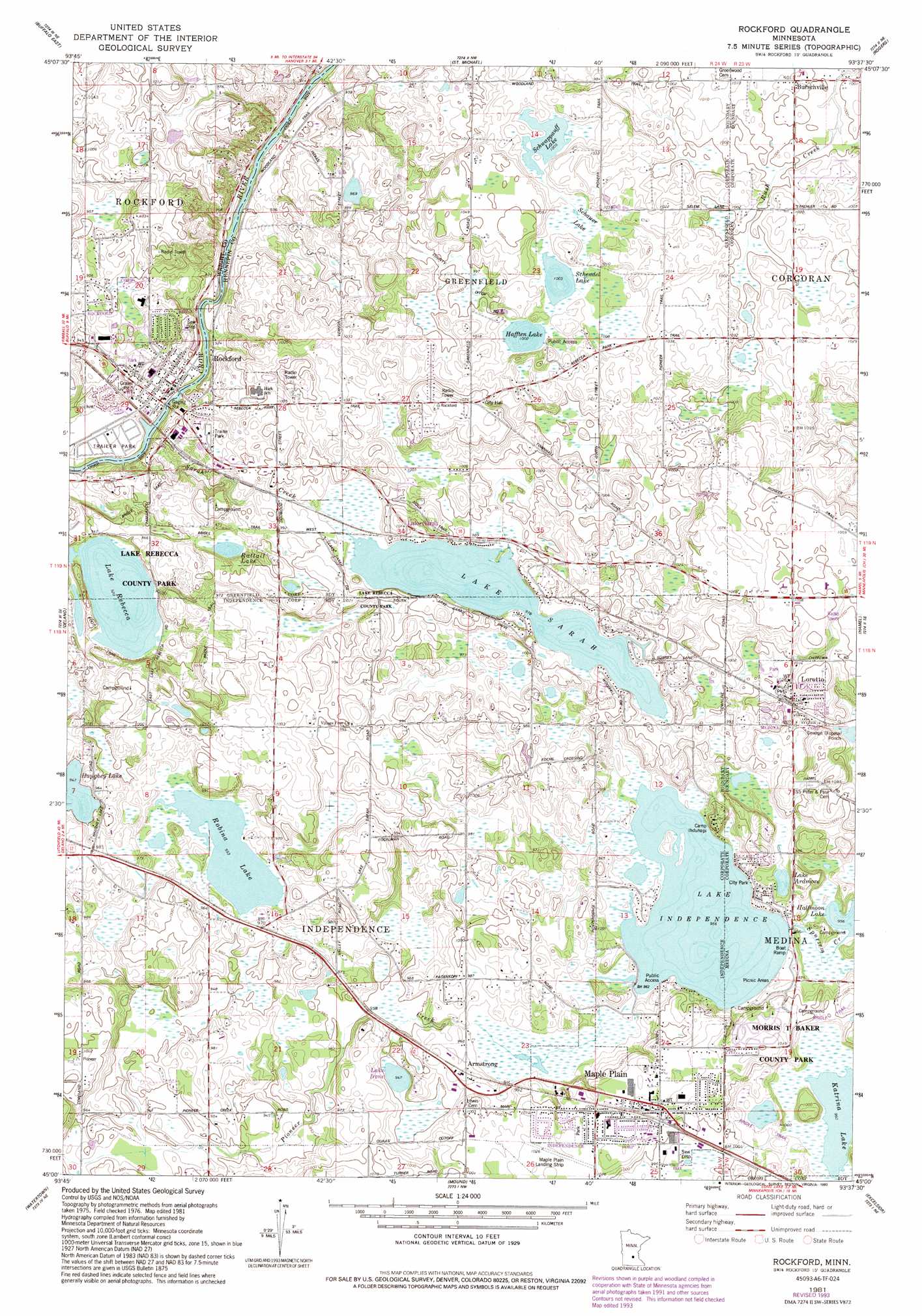
USGS Topo Quad 45093a6 - 1:24,000 scale
| Topo Map Name: | Rockford |
| USGS Topo Quad ID: | 45093a6 |
| Print Size: | ca. 21 1/4" wide x 27" high |
| Southeast Coordinates: | 45° N latitude / 93.625° W longitude |
| Map Center Coordinates: | 45.0625° N latitude / 93.6875° W longitude |
| U.S. State: | MN |
| Filename: | o45093a6.jpg |
| Download Map JPG Image: | Rockford topo map 1:24,000 scale |
| Map Type: | Topographic |
| Topo Series: | 7.5´ |
| Map Scale: | 1:24,000 |
| Source of Map Images: | United States Geological Survey (USGS) |
| Alternate Map Versions: |
Rockford MN 1981, updated 1981 Download PDF Buy paper map Rockford MN 1981, updated 1993 Download PDF Buy paper map Rockford MN 2010 Download PDF Buy paper map Rockford MN 2013 Download PDF Buy paper map Rockford MN 2016 Download PDF Buy paper map |
1:24,000 Topo Quads surrounding Rockford
Silver Creek |
Monticello |
Big Lake |
Elk River |
Nowthen |
Buffalo West |
Buffalo East |
Saint Michael |
Rogers |
Anoka |
Waverly |
Delano |
Rockford |
Hamel |
Osseo |
Mayer |
Watertown |
Mound |
Excelsior |
Hopkins |
Norwood |
Waconia |
Victoria |
Shakopee |
Eden Prairie |
> Back to 45093a1 at 1:100,000 scale
> Back to 45092a1 at 1:250,000 scale
> Back to U.S. Topo Maps home
Rockford topo map: Gazetteer
Rockford: Airports
Ingleside Airport elevation 305m 1000′Maple Airport elevation 312m 1023′
Maple Plain Landing Strip elevation 311m 1020′
Rockford: Canals
County Ditch Number Nine elevation 303m 994′Rockford: Dams
Mill Pond Dam elevation 307m 1007′Rockford: Lakes
Hafften Lake elevation 306m 1003′Halfmoon Lake elevation 291m 954′
Haughey Lake elevation 288m 944′
Lake Ardmore elevation 291m 954′
Lake Independence elevation 292m 958′
Lake Irene elevation 288m 944′
Lake Rebecca elevation 282m 925′
Lake Sarah elevation 298m 977′
Rattail Lake elevation 291m 954′
Robina Lake elevation 291m 954′
Schendel Lake elevation 306m 1003′
Schwappauff Lake elevation 306m 1003′
Rockford: Parks
Carver Park elevation 295m 967′Lake Rebecca County Park elevation 306m 1003′
Maple Hill Park elevation 307m 1007′
Rockford: Populated Places
Armstrong elevation 301m 987′Burschville elevation 306m 1003′
Greenfield elevation 305m 1000′
Independence elevation 298m 977′
Lake Sarah elevation 303m 994′
Loretto elevation 309m 1013′
Maple Plain elevation 313m 1026′
Rockford elevation 279m 915′
Rockford Riverview Estates elevation 280m 918′
Rockford: Post Offices
Burschville Post Office (historical) elevation 307m 1007′Lake Sarah Post Office (historical) elevation 304m 997′
Loretto Post Office elevation 309m 1013′
Maple Plain Post Office elevation 312m 1023′
Perkinsville Post Office (historical) elevation 307m 1007′
Rockford Post Office elevation 279m 915′
Rockford: Reservoirs
Crow River Reservoir elevation 307m 1007′Rockford: Streams
Sarah Creek elevation 273m 895′Spurzem Creek elevation 292m 958′
Rockford: Swamps
Schauer Lake elevation 308m 1010′Rockford digital topo map on disk
Buy this Rockford topo map showing relief, roads, GPS coordinates and other geographical features, as a high-resolution digital map file on DVD: