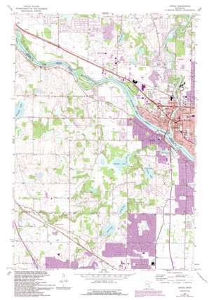
Anoka Topo Map Minnesota
To zoom in, hover over the map of Anoka
USGS Topo Quad 45093b4 - 1:24,000 scale
| Topo Map Name: | Anoka |
| USGS Topo Quad ID: | 45093b4 |
| Print Size: | ca. 21 1/4" wide x 27" high |
| Southeast Coordinates: | 45.125° N latitude / 93.375° W longitude |
| Map Center Coordinates: | 45.1875° N latitude / 93.4375° W longitude |
| U.S. State: | MN |
| Filename: | o45093b4.jpg |
| Download Map JPG Image: | Anoka topo map 1:24,000 scale |
| Map Type: | Topographic |
| Topo Series: | 7.5´ |
| Map Scale: | 1:24,000 |
| Source of Map Images: | United States Geological Survey (USGS) |
| Alternate Map Versions: |
Anoka MN 1955, updated 1956 Download PDF Buy paper map Anoka MN 1967, updated 1969 Download PDF Buy paper map Anoka MN 1967, updated 1973 Download PDF Buy paper map Anoka MN 1967, updated 1980 Download PDF Buy paper map Anoka MN 1967, updated 1993 Download PDF Buy paper map Anoka MN 2010 Download PDF Buy paper map Anoka MN 2013 Download PDF Buy paper map Anoka MN 2016 Download PDF Buy paper map |
1:24,000 Topo Quads surrounding Anoka
> Back to 45093a1 at 1:100,000 scale
> Back to 45092a1 at 1:250,000 scale
> Back to U.S. Topo Maps home
Anoka topo map: Gazetteer
Anoka: Airports
Gateway North Industrial Airport elevation 265m 869′Anoka: Crossings
Interchange 213 elevation 277m 908′Anoka: Dams
Elm Creek Dam elevation 257m 843′Rice Lake Dam elevation 274m 898′
Rum River Dam elevation 259m 849′
Anoka: Islands
Cloquet Island elevation 254m 833′Kings Island elevation 256m 839′
Anoka: Lakes
Dubay Lake elevation 279m 915′Goose Lake elevation 267m 875′
Grass Lake elevation 261m 856′
Hayden Lake elevation 260m 853′
Lemans Lake elevation 263m 862′
Mill Pond elevation 257m 843′
Mud Lake elevation 264m 866′
Powers Lake elevation 261m 856′
Anoka: Parks
Boundary Creek Park elevation 275m 902′Charest Park elevation 273m 895′
Doris A Kemp Park elevation 260m 853′
Ehlen Park elevation 260m 853′
Elm Creek Park elevation 274m 898′
Engles Park elevation 272m 892′
Forest View Pond Park elevation 283m 928′
Goodrich Park elevation 261m 856′
Green Park elevation 269m 882′
Highland Park elevation 265m 869′
Josephine Nunn Park elevation 264m 866′
King Park elevation 268m 879′
Maple Valley Trails elevation 273m 895′
North River Park elevation 256m 839′
Northland Park elevation 269m 882′
Oak Creek Park elevation 259m 849′
Park Street Park elevation 263m 862′
Point Park elevation 255m 836′
Reynolds Park elevation 265m 869′
Richardson Park elevation 261m 856′
River Bend Park elevation 259m 849′
Rum River Park elevation 259m 849′
Schmidt State Wildlife Management Area elevation 271m 889′
Ward Park elevation 257m 843′
Wethern Park elevation 262m 859′
Anoka: Populated Places
Anoka elevation 268m 879′Champlin elevation 260m 853′
Anoka: Post Offices
Anoka Post Office elevation 267m 875′Anoka: Reservoirs
Mill Pond elevation 257m 843′Rice Lake elevation 274m 898′
Anoka: Streams
Diamond Creek elevation 261m 856′Elm Creek elevation 254m 833′
Rum River elevation 254m 833′
Rush Creek elevation 263m 862′
Anoka digital topo map on disk
Buy this Anoka topo map showing relief, roads, GPS coordinates and other geographical features, as a high-resolution digital map file on DVD:


