Saint Michael Topo Map Minnesota
To zoom in, hover over the map of Saint Michael
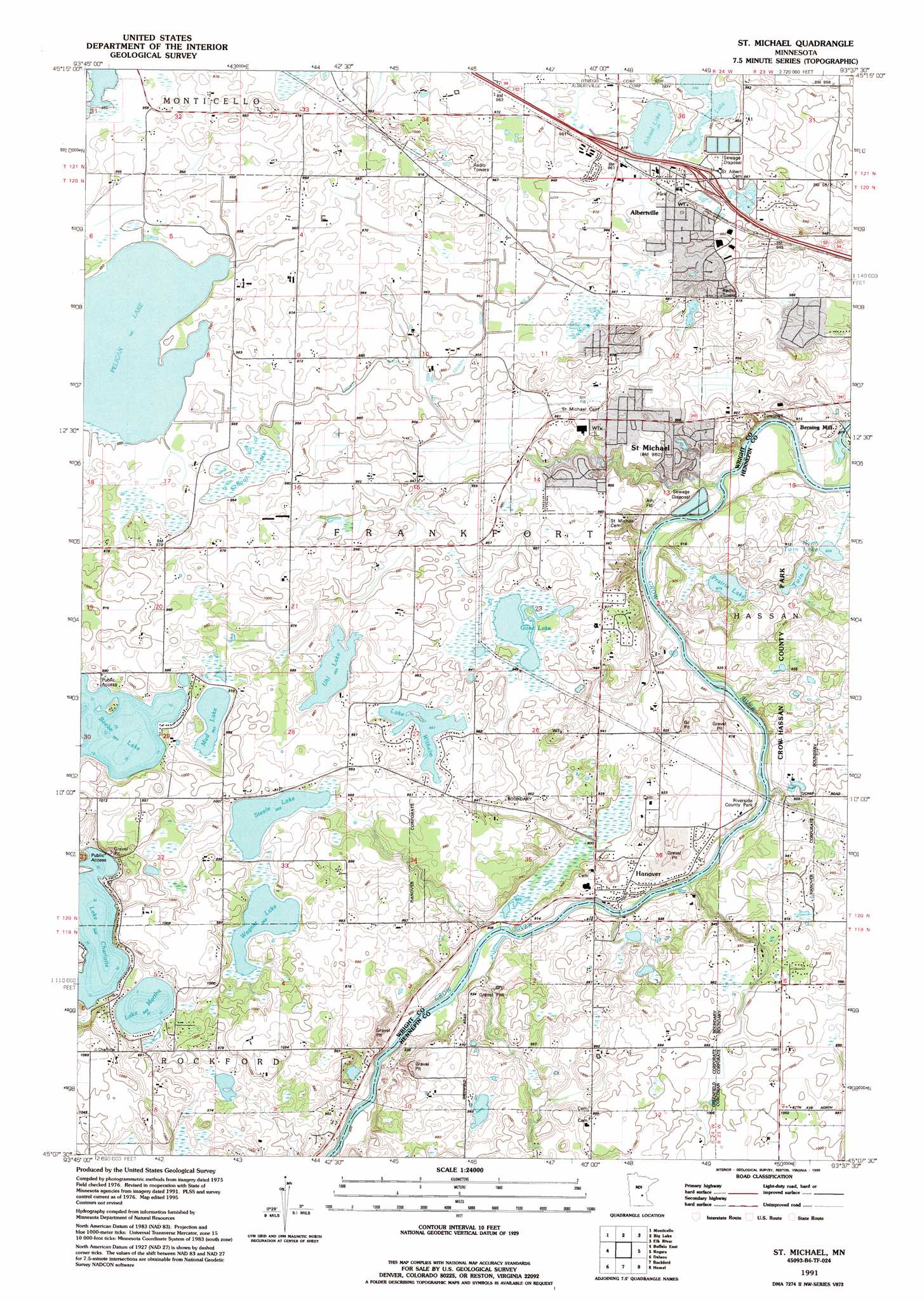
USGS Topo Quad 45093b6 - 1:24,000 scale
| Topo Map Name: | Saint Michael |
| USGS Topo Quad ID: | 45093b6 |
| Print Size: | ca. 21 1/4" wide x 27" high |
| Southeast Coordinates: | 45.125° N latitude / 93.625° W longitude |
| Map Center Coordinates: | 45.1875° N latitude / 93.6875° W longitude |
| U.S. State: | MN |
| Filename: | o45093b6.jpg |
| Download Map JPG Image: | Saint Michael topo map 1:24,000 scale |
| Map Type: | Topographic |
| Topo Series: | 7.5´ |
| Map Scale: | 1:24,000 |
| Source of Map Images: | United States Geological Survey (USGS) |
| Alternate Map Versions: |
St Michael MN 1981, updated 1981 Download PDF Buy paper map St Michael MN 1991, updated 1995 Download PDF Buy paper map Saint Michael MN 2010 Download PDF Buy paper map Saint Michael MN 2013 Download PDF Buy paper map Saint Michael MN 2016 Download PDF Buy paper map |
1:24,000 Topo Quads surrounding Saint Michael
Clear Lake |
Becker |
Orrock |
Lake Fremont |
Crown |
Silver Creek |
Monticello |
Big Lake |
Elk River |
Nowthen |
Buffalo West |
Buffalo East |
Saint Michael |
Rogers |
Anoka |
Waverly |
Delano |
Rockford |
Hamel |
Osseo |
Mayer |
Watertown |
Mound |
Excelsior |
Hopkins |
> Back to 45093a1 at 1:100,000 scale
> Back to 45092a1 at 1:250,000 scale
> Back to U.S. Topo Maps home
Saint Michael topo map: Gazetteer
Saint Michael: Airports
Johnson Airport elevation 308m 1010′Saint Michael: Crossings
Interchange 201 elevation 293m 961′Interchange 202 elevation 291m 954′
Saint Michael: Dams
Bernings Mill Dam (historical) elevation 286m 938′Welter Brothers Dam elevation 266m 872′
Saint Michael: Lakes
Beebe Lake elevation 294m 964′Gonz Lake elevation 285m 935′
Hunters Lake elevation 289m 948′
Lake Charlotte elevation 289m 948′
Lake Martha elevation 295m 967′
Lake Wilhelm elevation 290m 951′
Mud Lake elevation 294m 964′
North Twin Lake elevation 265m 869′
Prairie Lake elevation 267m 875′
School Lake elevation 289m 948′
Steele Lake elevation 295m 967′
Twin Lake elevation 267m 875′
Uhl Lake elevation 292m 958′
Wagner Lake elevation 295m 967′
Saint Michael: Parks
Riverside County Park elevation 274m 898′Saint Michael: Populated Places
Albertville elevation 293m 961′Hanover elevation 281m 921′
Saint Michael elevation 294m 964′
Saint Michael: Post Offices
Albertville Post Office elevation 291m 954′Hanover Post Office elevation 281m 921′
Saint Michael Post Office elevation 293m 961′
Saint Michael: Reservoirs
Crow River Reservoir (historical) elevation 286m 938′Saint Michael: Swamps
School Lake elevation 289m 948′Saint Michael digital topo map on disk
Buy this Saint Michael topo map showing relief, roads, GPS coordinates and other geographical features, as a high-resolution digital map file on DVD: