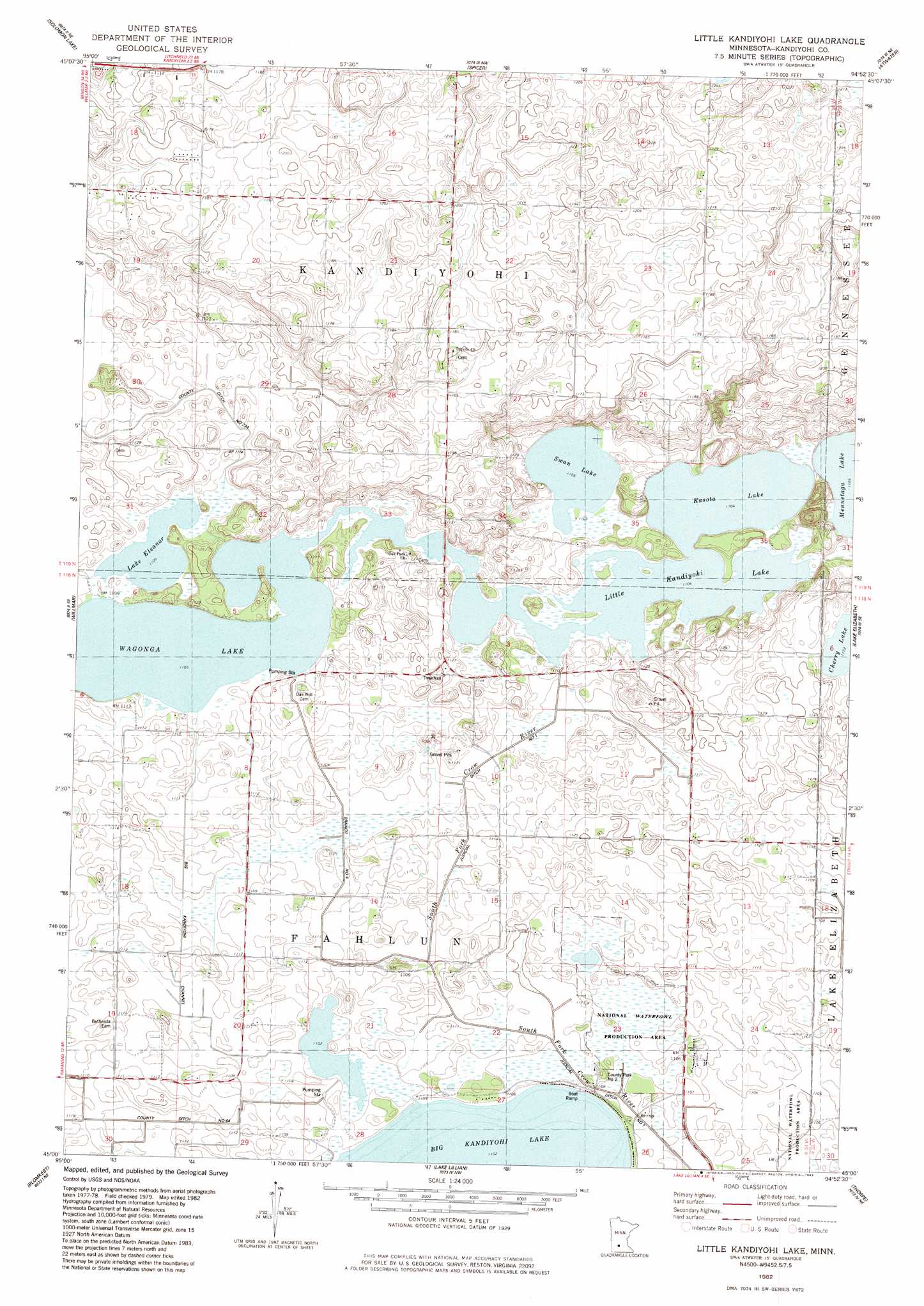
Little Kandiyohi Lake Topo Map Minnesota
To zoom in, hover over the map of Little Kandiyohi Lake
USGS Topo Quad 45094a8 - 1:24,000 scale
| Topo Map Name: | Little Kandiyohi Lake |
| USGS Topo Quad ID: | 45094a8 |
| Print Size: | ca. 21 1/4" wide x 27" high |
| Southeast Coordinates: | 45° N latitude / 94.875° W longitude |
| Map Center Coordinates: | 45.0625° N latitude / 94.9375° W longitude |
| U.S. State: | MN |
| Filename: | o45094a8.jpg |
| Download Map JPG Image: | Little Kandiyohi Lake topo map 1:24,000 scale |
| Map Type: | Topographic |
| Topo Series: | 7.5´ |
| Map Scale: | 1:24,000 |
| Source of Map Images: | United States Geological Survey (USGS) |
| Alternate Map Versions: |
Little Kandiyohi Lake MN 1982, updated 1983 Download PDF Buy paper map Little Kandiyohi Lake MN 2010 Download PDF Buy paper map Little Kandiyohi Lake MN 2013 Download PDF Buy paper map Little Kandiyohi Lake MN 2016 Download PDF Buy paper map |
1:24,000 Topo Quads surrounding Little Kandiyohi Lake
Sunburg |
Mount Tom |
New London |
Hawick |
Lake Koronis |
Pennock |
Solomon Lake |
Spicer |
Atwater |
Grove City |
Raymond |
Willmar |
Little Kandiyohi Lake |
Lake Elizabeth |
Rosendale |
Prinsburg |
Blomkest |
Lake Lillian |
Thorpe |
Cosmos |
Renville |
Danube |
Olivia |
Olivia Se |
Churchill |
> Back to 45094a1 at 1:100,000 scale
> Back to 45094a1 at 1:250,000 scale
> Back to U.S. Topo Maps home
Little Kandiyohi Lake topo map: Gazetteer
Little Kandiyohi Lake: Canals
Big Kandiyohi Channel elevation 338m 1108′Branch Number Four elevation 335m 1099′
County Ditch Number Sixtyfour elevation 336m 1102′
County Ditch Number Twentythree A elevation 339m 1112′
Judicial Ditch Number One elevation 336m 1102′
Little Kandiyohi Lake: Dams
Kandiyohi Lake Inlet Dam elevation 336m 1102′Little Kandiyohi Lake Dam elevation 339m 1112′
Little Kandiyohi Lake: Lakes
Cherry Lake elevation 345m 1131′Fanny Lake elevation 336m 1102′
Kasota Lake elevation 336m 1102′
Lake Eleanor elevation 336m 1102′
Lake Wakanda elevation 337m 1105′
Little Kandiyohi Lake elevation 336m 1102′
Swan Lake elevation 336m 1102′
Little Kandiyohi Lake: Parks
County Park Number Two elevation 336m 1102′Little Kandiyohi Lake: Reservoirs
Kandiyohi Lake elevation 336m 1102′Little Kandiyohi Lake elevation 339m 1112′
Little Kandiyohi Lake digital topo map on disk
Buy this Little Kandiyohi Lake topo map showing relief, roads, GPS coordinates and other geographical features, as a high-resolution digital map file on DVD: