Farming Topo Map Minnesota
To zoom in, hover over the map of Farming
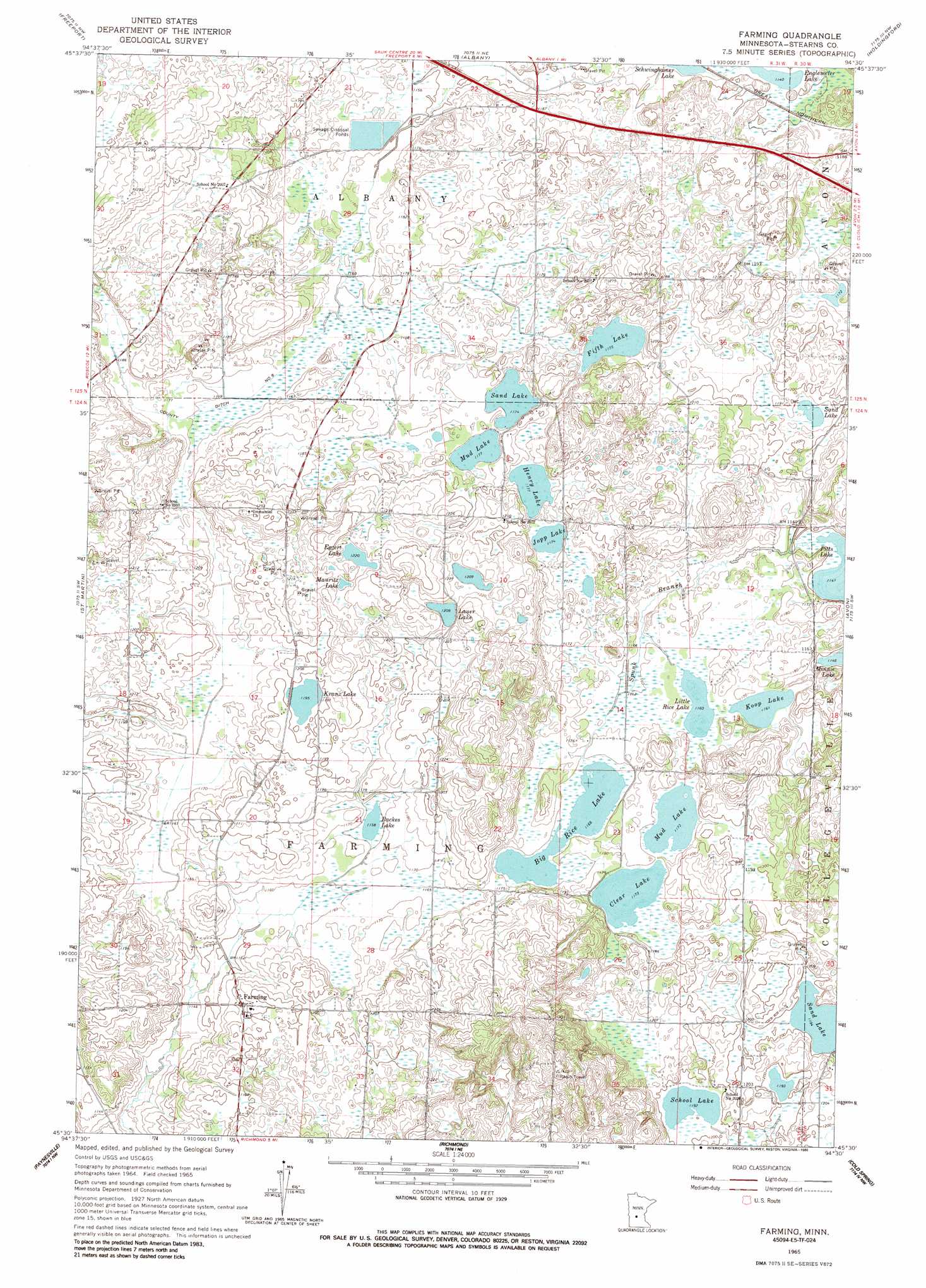
USGS Topo Quad 45094e5 - 1:24,000 scale
| Topo Map Name: | Farming |
| USGS Topo Quad ID: | 45094e5 |
| Print Size: | ca. 21 1/4" wide x 27" high |
| Southeast Coordinates: | 45.5° N latitude / 94.5° W longitude |
| Map Center Coordinates: | 45.5625° N latitude / 94.5625° W longitude |
| U.S. State: | MN |
| Filename: | o45094e5.jpg |
| Download Map JPG Image: | Farming topo map 1:24,000 scale |
| Map Type: | Topographic |
| Topo Series: | 7.5´ |
| Map Scale: | 1:24,000 |
| Source of Map Images: | United States Geological Survey (USGS) |
| Alternate Map Versions: |
Farming MN 1965, updated 1966 Download PDF Buy paper map Farming MN 1965, updated 1986 Download PDF Buy paper map Farming MN 2010 Download PDF Buy paper map Farming MN 2013 Download PDF Buy paper map Farming MN 2016 Download PDF Buy paper map |
1:24,000 Topo Quads surrounding Farming
Ward Springs |
Burtrum |
Upsala |
Bowlus |
Royalton |
Melrose |
Freeport |
Albany |
Holdingford |
Saint Stephen |
Greenwald |
Saint Martin |
Farming |
Avon |
Saint Joseph |
Lake Henry |
Paynesville |
Richmond |
Cold Spring |
Rockville |
Hawick |
Lake Koronis |
Eden Valley |
Watkins |
Kimball |
> Back to 45094e1 at 1:100,000 scale
> Back to 45094a1 at 1:250,000 scale
> Back to U.S. Topo Maps home
Farming topo map: Gazetteer
Farming: Canals
County Ditch Number Six elevation 355m 1164′Farming: Lakes
Backes Lake elevation 351m 1151′Big Rice Lake elevation 354m 1161′
Clear Lake elevation 357m 1171′
Eggert Lake elevation 372m 1220′
Englemeier Lake elevation 348m 1141′
Fifth Lake elevation 357m 1171′
Henry Lake elevation 357m 1171′
Jopp Lake elevation 357m 1171′
Koop Lake elevation 354m 1161′
Kranz Lake elevation 363m 1190′
Lauer Lake elevation 366m 1200′
Little Rice Lake elevation 354m 1161′
Mauritz Lake elevation 371m 1217′
Mud Lake elevation 357m 1171′
Mud Lake elevation 357m 1171′
Pitts Lake elevation 348m 1141′
Sand Lake elevation 360m 1181′
Sand Lake elevation 357m 1171′
Sand Lake elevation 363m 1190′
School Lake elevation 363m 1190′
Schwinghamer Lake elevation 345m 1131′
Farming: Populated Places
Farming elevation 360m 1181′Farming: Post Offices
Farming Post Office (historical) elevation 361m 1184′Farming digital topo map on disk
Buy this Farming topo map showing relief, roads, GPS coordinates and other geographical features, as a high-resolution digital map file on DVD: