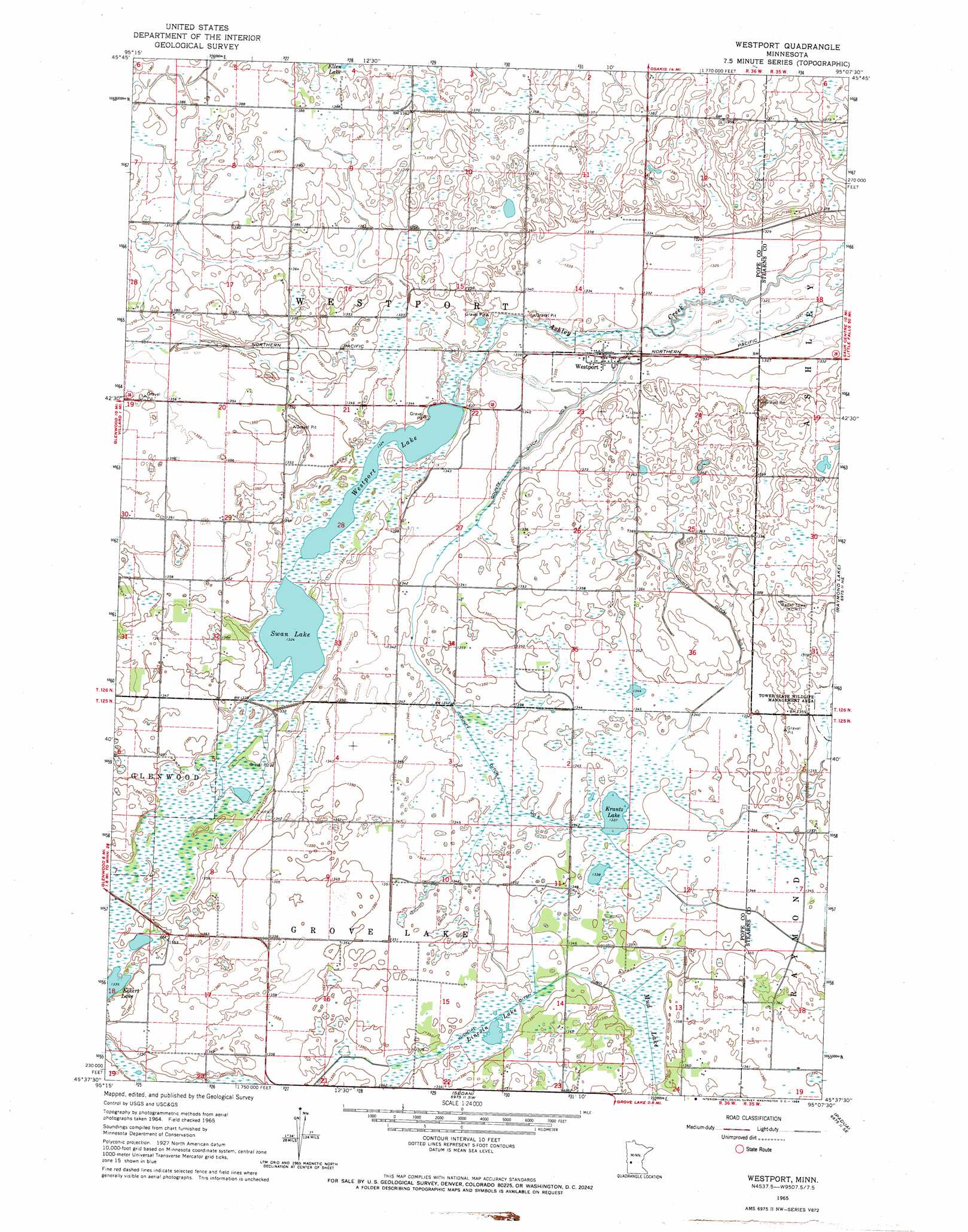
Westport Topo Map Minnesota
To zoom in, hover over the map of Westport
USGS Topo Quad 45095f2 - 1:24,000 scale
| Topo Map Name: | Westport |
| USGS Topo Quad ID: | 45095f2 |
| Print Size: | ca. 21 1/4" wide x 27" high |
| Southeast Coordinates: | 45.625° N latitude / 95.125° W longitude |
| Map Center Coordinates: | 45.6875° N latitude / 95.1875° W longitude |
| U.S. State: | MN |
| Filename: | o45095f2.jpg |
| Download Map JPG Image: | Westport topo map 1:24,000 scale |
| Map Type: | Topographic |
| Topo Series: | 7.5´ |
| Map Scale: | 1:24,000 |
| Source of Map Images: | United States Geological Survey (USGS) |
| Alternate Map Versions: |
Westport MN 1965, updated 1966 Download PDF Buy paper map Westport MN 2010 Download PDF Buy paper map Westport MN 2013 Download PDF Buy paper map Westport MN 2016 Download PDF Buy paper map |
1:24,000 Topo Quads surrounding Westport
Alexandria West |
Alexandria East |
Lake Osakis West |
Lake Osakis East |
Round Prairie |
Lake Mary |
Forada |
Osakis |
West Union |
Sauk Lake |
Glenwood |
Villard |
Westport |
Raymond Lake |
Sauk Centre |
Lake Minnewaska |
Terrace |
Sedan |
Padua |
Elrosa |
Swift Falls |
Lake Simon |
Lake Johanna |
Belgrade |
Georgeville |
> Back to 45095e1 at 1:100,000 scale
> Back to 45094a1 at 1:250,000 scale
> Back to U.S. Topo Maps home
Westport topo map: Gazetteer
Westport: Canals
County Ditch Number Eleven elevation 412m 1351′County Ditch Number Six elevation 408m 1338′
Judicial Ditch Number One elevation 409m 1341′
Westport: Lakes
Krantz Lake elevation 407m 1335′Lincoln Lake elevation 408m 1338′
Swan Lake elevation 404m 1325′
Westport Lake elevation 404m 1325′
Westport: Parks
Tower State Wildlife Management Area elevation 413m 1354′Westport: Populated Places
Westport elevation 406m 1332′Westport: Post Offices
Westport Post Office (historical) elevation 406m 1332′Westport: Swamps
Mud Lake elevation 406m 1332′Westport digital topo map on disk
Buy this Westport topo map showing relief, roads, GPS coordinates and other geographical features, as a high-resolution digital map file on DVD: