Patch Skin Buttes Se Topo Map South Dakota
To zoom in, hover over the map of Patch Skin Buttes Se
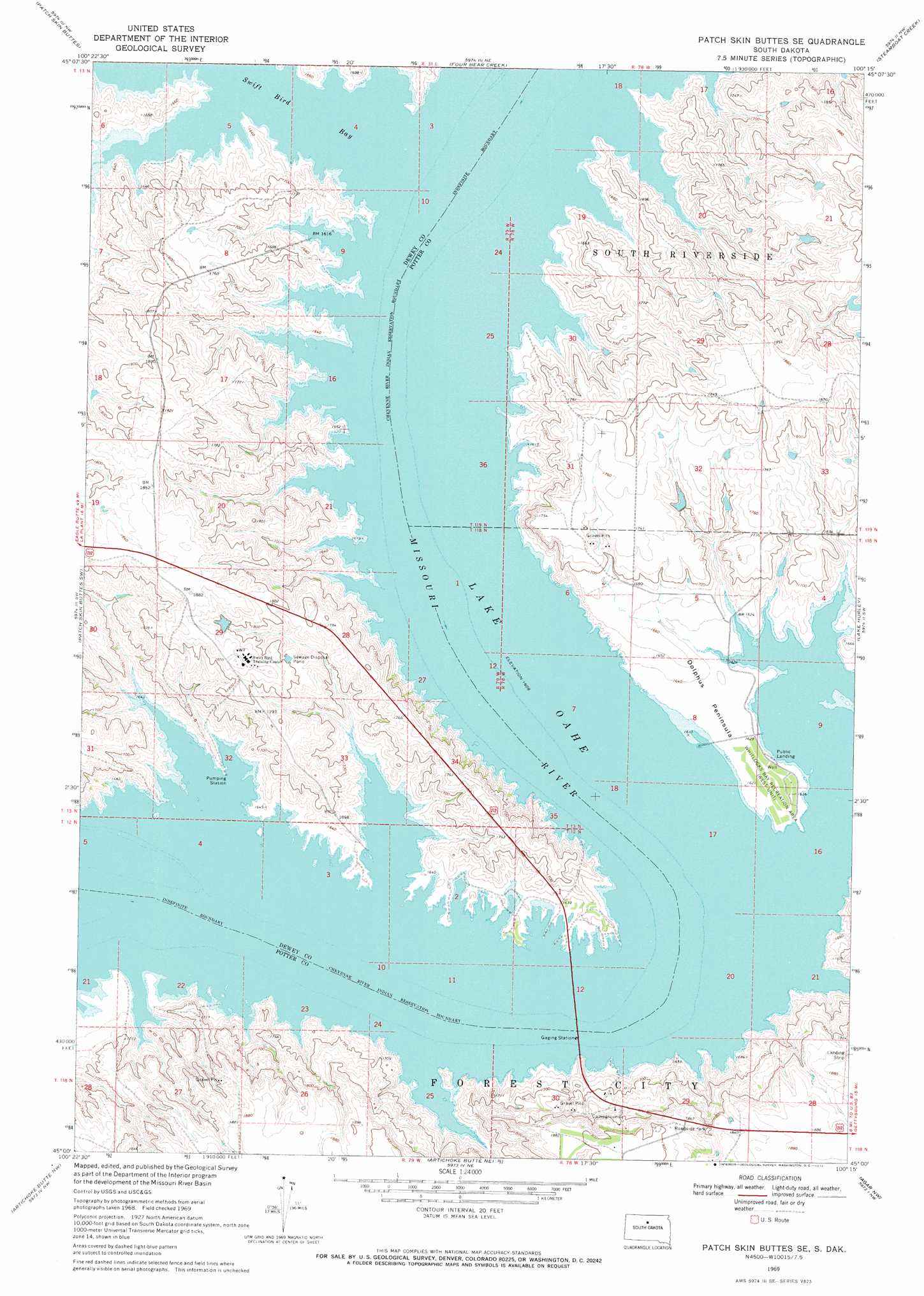
USGS Topo Quad 45100a3 - 1:24,000 scale
| Topo Map Name: | Patch Skin Buttes Se |
| USGS Topo Quad ID: | 45100a3 |
| Print Size: | ca. 21 1/4" wide x 27" high |
| Southeast Coordinates: | 45° N latitude / 100.25° W longitude |
| Map Center Coordinates: | 45.0625° N latitude / 100.3125° W longitude |
| U.S. State: | SD |
| Filename: | o45100a3.jpg |
| Download Map JPG Image: | Patch Skin Buttes Se topo map 1:24,000 scale |
| Map Type: | Topographic |
| Topo Series: | 7.5´ |
| Map Scale: | 1:24,000 |
| Source of Map Images: | United States Geological Survey (USGS) |
| Alternate Map Versions: |
Patch Skin Buttes SE SD 1969, updated 1972 Download PDF Buy paper map Patch Skin Buttes SE SD 2012 Download PDF Buy paper map Patch Skin Buttes SE SD 2015 Download PDF Buy paper map |
1:24,000 Topo Quads surrounding Patch Skin Buttes Se
Promise |
Moreau |
Moreau Se |
Akaska Sw |
Akaska |
Virginia |
Patch Skin Buttes |
Four Bear Creek |
Steamboat Creek |
Lake Hurley Ne |
Stove Creek |
Patch Skin Buttes Sw |
Patch Skin Buttes Se |
Lake Hurley |
Lake Hurley Se |
No Heart Creek Ne |
Artichoke Butte Nw |
Artichoke Butte Ne |
Agar Nw |
Agar Ne |
No Heart Creek Se |
Artichoke Butte Sw |
Artichoke Butte |
Agar Sw |
Agar |
> Back to 45100a1 at 1:100,000 scale
> Back to 45100a1 at 1:250,000 scale
> Back to U.S. Topo Maps home
Patch Skin Buttes Se topo map: Gazetteer
Patch Skin Buttes Se: Arroyos
Swedes Draw (historical) elevation 490m 1607′Patch Skin Buttes Se: Bays
Swift Bird Bay elevation 490m 1607′Patch Skin Buttes Se: Capes
Dolphus Peninsula elevation 498m 1633′Patch Skin Buttes Se: Dams
Carl Cronin Dam elevation 549m 1801′Patch Skin Buttes Se: Islands
Bullberry Island (historical) elevation 490m 1607′Pascals Island (historical) elevation 490m 1607′
Patch Skin Buttes Se: Parks
Forest City Recreation Area elevation 491m 1610′Whitlocks Bay Recreation Area elevation 498m 1633′
Patch Skin Buttes Se: Populated Places
Forest City elevation 566m 1856′Patch Skin Buttes Se digital topo map on disk
Buy this Patch Skin Buttes Se topo map showing relief, roads, GPS coordinates and other geographical features, as a high-resolution digital map file on DVD:
Eastern North Dakota & Eastern South Dakota
Buy digital topo maps: Eastern North Dakota & Eastern South Dakota