Mobridge Topo Map South Dakota
To zoom in, hover over the map of Mobridge
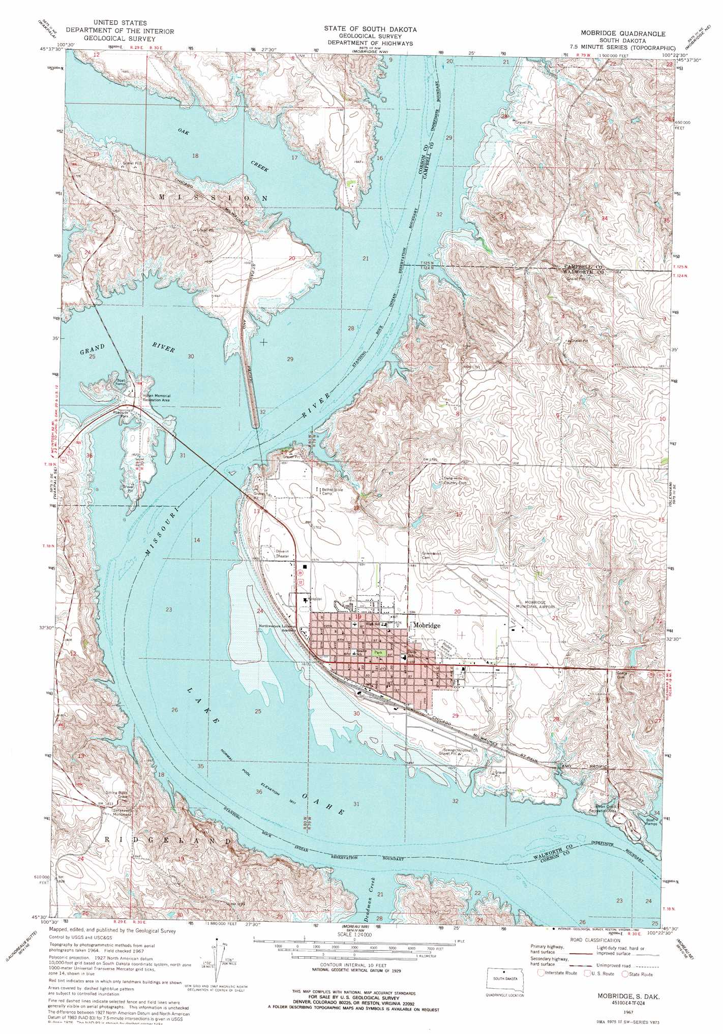
USGS Topo Quad 45100e4 - 1:24,000 scale
| Topo Map Name: | Mobridge |
| USGS Topo Quad ID: | 45100e4 |
| Print Size: | ca. 21 1/4" wide x 27" high |
| Southeast Coordinates: | 45.5° N latitude / 100.375° W longitude |
| Map Center Coordinates: | 45.5625° N latitude / 100.4375° W longitude |
| U.S. State: | SD |
| Filename: | o45100e4.jpg |
| Download Map JPG Image: | Mobridge topo map 1:24,000 scale |
| Map Type: | Topographic |
| Topo Series: | 7.5´ |
| Map Scale: | 1:24,000 |
| Source of Map Images: | United States Geological Survey (USGS) |
| Alternate Map Versions: |
Mobridge SD 1967, updated 1969 Download PDF Buy paper map Mobridge SD 1967, updated 1992 Download PDF Buy paper map Mobridge SD 2012 Download PDF Buy paper map Mobridge SD 2015 Download PDF Buy paper map |
1:24,000 Topo Quads surrounding Mobridge
Mahto |
Kline Buttes |
Kenel |
Pollock Se |
Herreid Sw |
Wakpala Nw |
Wakpala |
Mobridge Nw |
Mobridge Ne |
Selby Nw |
Wakpala Sw |
Wakpala Se |
Mobridge |
Glenham |
Selby Sw |
Trail City |
Laundreaux Butte |
Moreau Nw |
Moreau Ne |
Akaska Nw |
Trail City Sw |
Promise |
Moreau |
Moreau Se |
Akaska Sw |
> Back to 45100e1 at 1:100,000 scale
> Back to 45100a1 at 1:250,000 scale
> Back to U.S. Topo Maps home
Mobridge topo map: Gazetteer
Mobridge: Airports
Mobridge Airport (historical) elevation 510m 1673′Mobridge Municipal Airport elevation 534m 1751′
Mobridge: Bays
Smith Bay elevation 490m 1607′Mobridge: Dams
T Scholzen-Glen Schillingstad Dam elevation 544m 1784′Mobridge: Islands
Ashley Island (historical) elevation 490m 1607′Blue Blanket Island (historical) elevation 490m 1607′
Mobridge: Parks
Bethel Bible Camp elevation 517m 1696′Indian Creek Recreation Area elevation 491m 1610′
Indian Memorial Recreation Area elevation 495m 1624′
Mobridge: Populated Places
Mobridge elevation 506m 1660′Mobridge: Post Offices
Flora Post Office (historical) elevation 501m 1643′Mobridge: Streams
Deadman Creek elevation 490m 1607′Grand River elevation 490m 1607′
Oak Creek elevation 490m 1607′
Mobridge digital topo map on disk
Buy this Mobridge topo map showing relief, roads, GPS coordinates and other geographical features, as a high-resolution digital map file on DVD:
Eastern North Dakota & Eastern South Dakota
Buy digital topo maps: Eastern North Dakota & Eastern South Dakota