Isabel Topo Map South Dakota
To zoom in, hover over the map of Isabel
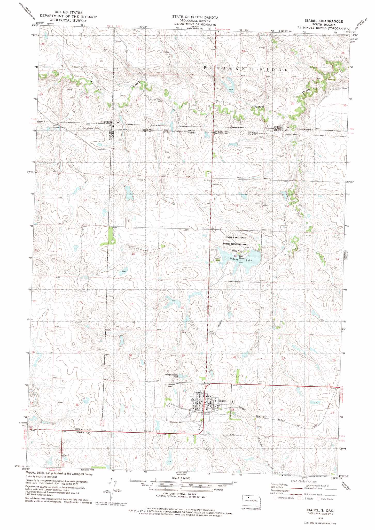
USGS Topo Quad 45101d4 - 1:24,000 scale
| Topo Map Name: | Isabel |
| USGS Topo Quad ID: | 45101d4 |
| Print Size: | ca. 21 1/4" wide x 27" high |
| Southeast Coordinates: | 45.375° N latitude / 101.375° W longitude |
| Map Center Coordinates: | 45.4375° N latitude / 101.4375° W longitude |
| U.S. State: | SD |
| Filename: | o45101d4.jpg |
| Download Map JPG Image: | Isabel topo map 1:24,000 scale |
| Map Type: | Topographic |
| Topo Series: | 7.5´ |
| Map Scale: | 1:24,000 |
| Source of Map Images: | United States Geological Survey (USGS) |
| Alternate Map Versions: |
Isabel SD 1978, updated 1979 Download PDF Buy paper map Isabel SD 2012 Download PDF Buy paper map Isabel SD 2015 Download PDF Buy paper map |
1:24,000 Topo Quads surrounding Isabel
Cottonwood Creek Nw |
Cottonwood Creek Ne |
Black Horse |
Black Horse Ne |
Miscol |
Cottonwood Creek Sw |
Cottonwood Creek Se |
Black Horse Sw |
Black Horse Se |
Miscol Sw |
Irish Creek Nw |
Irish Creek Ne |
Isabel |
Firesteel |
Brewer Butte |
Irish Creek Sw |
Irish Creek Se |
Isabel Sw |
Peach Lake |
Livermant Lake |
Thunder Butte |
Dupree Ne |
Lantry Nw |
Lantry Ne |
Parade Nw |
> Back to 45101a1 at 1:100,000 scale
> Back to 45100a1 at 1:250,000 scale
> Back to U.S. Topo Maps home
Isabel topo map: Gazetteer
Isabel: Airports
Isabel Municipal Airport elevation 723m 2372′Isabel: Dams
Bill Lindshov Dam elevation 671m 2201′D Woddell Dam elevation 703m 2306′
G and J Heck Number 1 Dam elevation 711m 2332′
G and J Heck Number 2 Dam elevation 710m 2329′
G and J Heck Number 2 Dam elevation 706m 2316′
G Boldt Dam elevation 718m 2355′
Isabel Lake Dam elevation 689m 2260′
John Meginess Dam elevation 691m 2267′
R Clark Number 1 Dam elevation 698m 2290′
R Clark Number 2 Dam elevation 699m 2293′
R Clark Number 3 Dam elevation 696m 2283′
S Tidball Dam elevation 718m 2355′
Isabel: Parks
Isabel Lake State Public Shooting Area elevation 690m 2263′Isabel: Populated Places
Isabel elevation 731m 2398′Isabel: Reservoirs
Isabel Lake elevation 689m 2260′Isabel digital topo map on disk
Buy this Isabel topo map showing relief, roads, GPS coordinates and other geographical features, as a high-resolution digital map file on DVD:
Eastern North Dakota & Eastern South Dakota
Buy digital topo maps: Eastern North Dakota & Eastern South Dakota