Caroline Butte Topo Map South Dakota
To zoom in, hover over the map of Caroline Butte
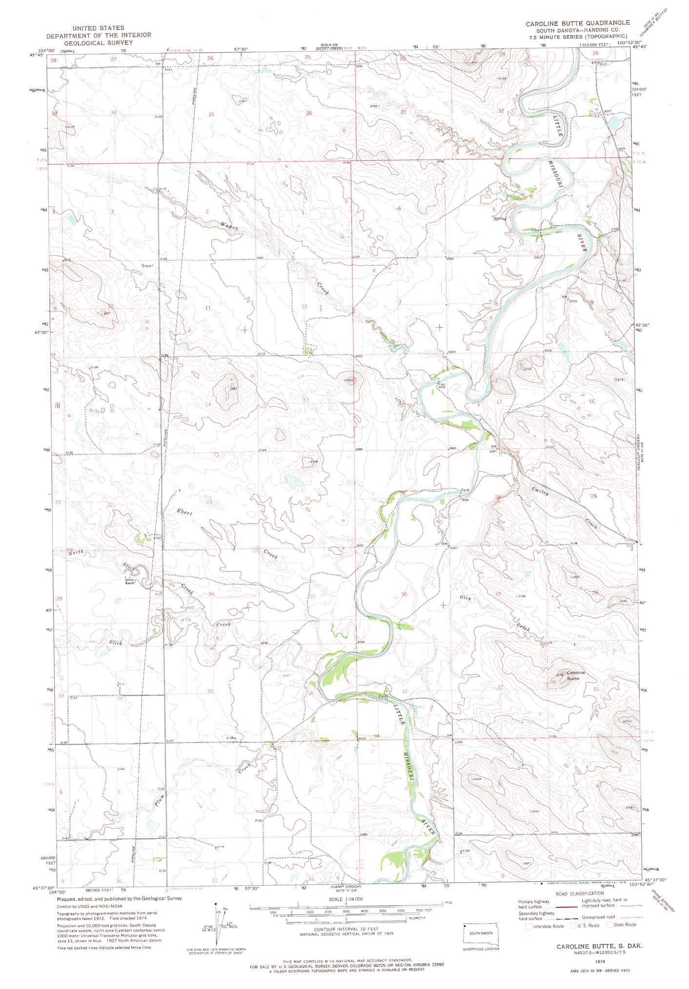
USGS Topo Quad 45103f8 - 1:24,000 scale
| Topo Map Name: | Caroline Butte |
| USGS Topo Quad ID: | 45103f8 |
| Print Size: | ca. 21 1/4" wide x 27" high |
| Southeast Coordinates: | 45.625° N latitude / 103.875° W longitude |
| Map Center Coordinates: | 45.6875° N latitude / 103.9375° W longitude |
| U.S. State: | SD |
| Filename: | o45103f8.jpg |
| Download Map JPG Image: | Caroline Butte topo map 1:24,000 scale |
| Map Type: | Topographic |
| Topo Series: | 7.5´ |
| Map Scale: | 1:24,000 |
| Source of Map Images: | United States Geological Survey (USGS) |
| Alternate Map Versions: |
Caroline Butte SD 1974, updated 1976 Download PDF Buy paper map Caroline Butte SD 2012 Download PDF Buy paper map Caroline Butte SD 2015 Download PDF Buy paper map |
1:24,000 Topo Quads surrounding Caroline Butte
Flasted Hill |
Snider Hill |
Doaks Butte |
Dogie Butte |
Table Mountain |
Mill Iron |
Humbolt Hills |
Scott Creek |
Chimney Butte |
Ladner |
Rustler Divide |
North Slick Creek |
Caroline Butte |
Gallup Creek |
Lahti Butte |
Timber Hill |
Capitol Rock |
Camp Crook |
Pine Spring |
Saddle Butte |
Capitol Nw |
Capitol |
J K Butte |
Harding |
Bog Creek |
> Back to 45103e1 at 1:100,000 scale
> Back to 45102a1 at 1:250,000 scale
> Back to U.S. Topo Maps home
Caroline Butte topo map: Gazetteer
Caroline Butte: Streams
Ebert Creek elevation 930m 3051′North Slick Creek elevation 942m 3090′
North Slick Creek elevation 942m 3090′
Oley Creek elevation 927m 3041′
Plum Creek elevation 934m 3064′
Plum Creek elevation 934m 3064′
Slick Creek elevation 929m 3047′
Slick Creek elevation 929m 3047′
Smiley Creek elevation 927m 3041′
Wagon Creek elevation 923m 3028′
Wagon Creek elevation 923m 3028′
Caroline Butte: Summits
Caroline Butte elevation 998m 3274′Caroline Butte digital topo map on disk
Buy this Caroline Butte topo map showing relief, roads, GPS coordinates and other geographical features, as a high-resolution digital map file on DVD:
Eastern Montana & Western North Dakota
Buy digital topo maps: Eastern Montana & Western North Dakota