Eagles Nest Butte Topo Map South Dakota
To zoom in, hover over the map of Eagles Nest Butte
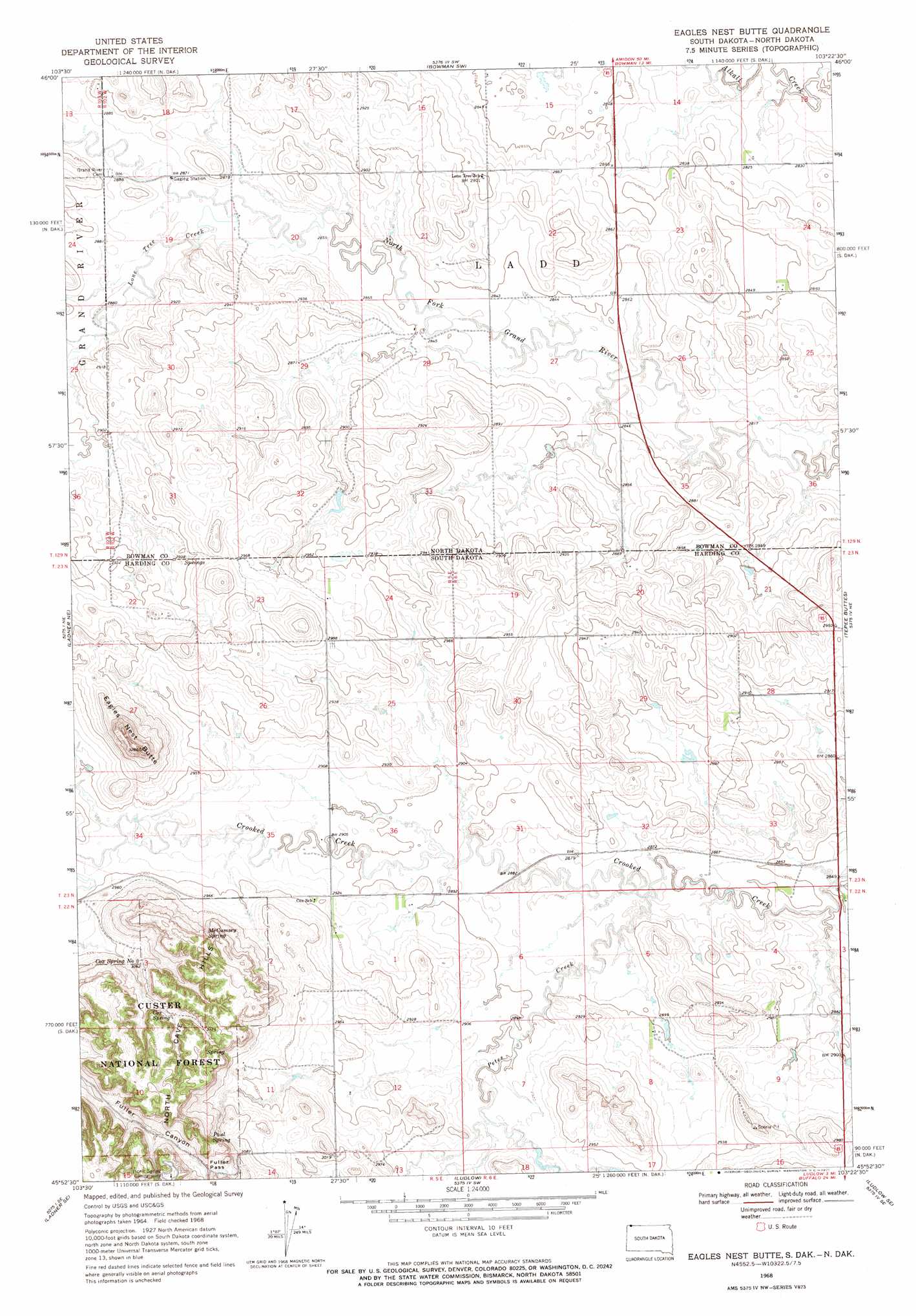
USGS Topo Quad 45103h4 - 1:24,000 scale
| Topo Map Name: | Eagles Nest Butte |
| USGS Topo Quad ID: | 45103h4 |
| Print Size: | ca. 21 1/4" wide x 27" high |
| Southeast Coordinates: | 45.875° N latitude / 103.375° W longitude |
| Map Center Coordinates: | 45.9375° N latitude / 103.4375° W longitude |
| U.S. States: | SD, ND |
| Filename: | o45103h4.jpg |
| Download Map JPG Image: | Eagles Nest Butte topo map 1:24,000 scale |
| Map Type: | Topographic |
| Topo Series: | 7.5´ |
| Map Scale: | 1:24,000 |
| Source of Map Images: | United States Geological Survey (USGS) |
| Alternate Map Versions: |
Eagles Nest Butte SD 1968, updated 1971 Download PDF Buy paper map Eagles Nest Butte SD 1993, updated 1996 Download PDF Buy paper map Eagles Nest Butte SD 2005, updated 2007 Download PDF Buy paper map Eagles Nest Butte SD 2012 Download PDF Buy paper map Eagles Nest Butte SD 2015 Download PDF Buy paper map |
| FStopo: | US Forest Service topo Eagles Nest Butte is available: Download FStopo PDF Download FStopo TIF |
1:24,000 Topo Quads surrounding Eagles Nest Butte
Rhame |
Griffin |
Bowman |
Talbot Butte |
Scranton |
Camel Butte |
Rhame Se |
Bowman Sw |
Bowman Se |
Scranton Sw |
Table Mountain |
Ladner Ne |
Eagles Nest Butte |
Tepee Buttes |
Bowman-Haley Dam |
Ladner |
Ladner Se |
Ludlow |
Ludlow Se |
Ralph Sw |
Lahti Butte |
Mckenzie Butte |
Hay Creek |
Sheep Pen Draw |
Reva Nw |
> Back to 45103e1 at 1:100,000 scale
> Back to 45102a1 at 1:250,000 scale
> Back to U.S. Topo Maps home
Eagles Nest Butte topo map: Gazetteer
Eagles Nest Butte: Gaps
Fuller Pass elevation 962m 3156′Eagles Nest Butte: Springs
Cox Spring elevation 939m 3080′Cox Spring Number Two elevation 936m 3070′
McCumsey Spring elevation 939m 3080′
Paul Spring elevation 947m 3106′
Eagles Nest Butte: Streams
Lone Tree Creek elevation 872m 2860′Lone Tree Creek elevation 872m 2860′
Petes Creek elevation 870m 2854′
Eagles Nest Butte: Summits
Eagles Nest Butte elevation 990m 3248′Eagles Nest Butte digital topo map on disk
Buy this Eagles Nest Butte topo map showing relief, roads, GPS coordinates and other geographical features, as a high-resolution digital map file on DVD:
Eastern Montana & Western North Dakota
Buy digital topo maps: Eastern Montana & Western North Dakota