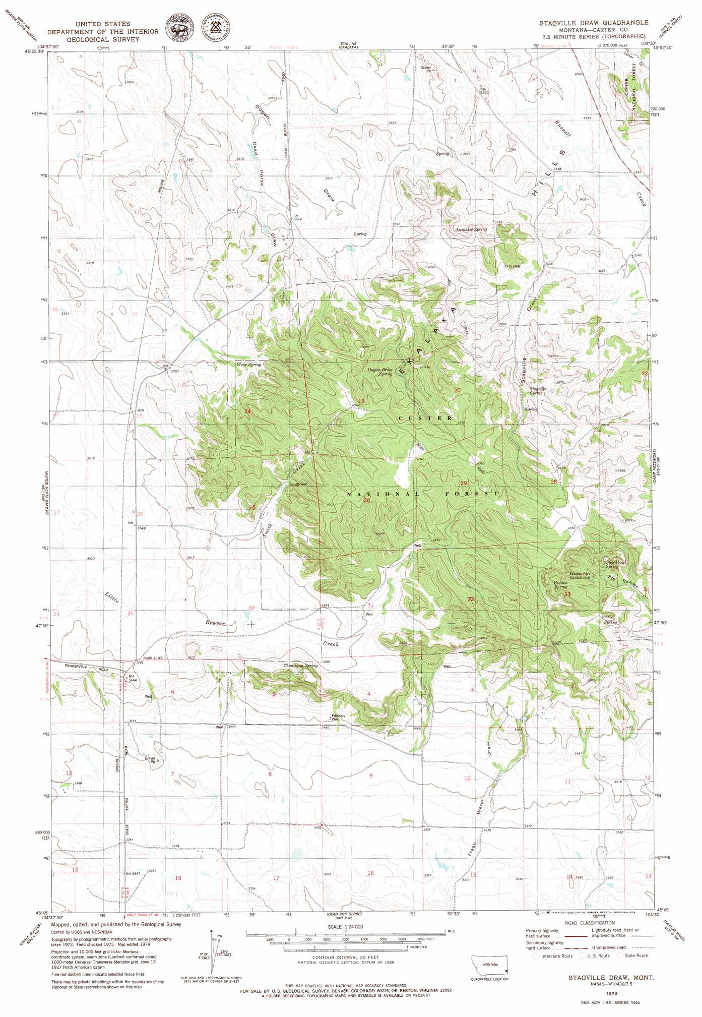
Stagville Draw Topo Map Montana
To zoom in, hover over the map of Stagville Draw
USGS Topo Quad 45104g5 - 1:24,000 scale
| Topo Map Name: | Stagville Draw |
| USGS Topo Quad ID: | 45104g5 |
| Print Size: | ca. 21 1/4" wide x 27" high |
| Southeast Coordinates: | 45.75° N latitude / 104.5° W longitude |
| Map Center Coordinates: | 45.8125° N latitude / 104.5625° W longitude |
| U.S. State: | MT |
| Filename: | o45104g5.jpg |
| Download Map JPG Image: | Stagville Draw topo map 1:24,000 scale |
| Map Type: | Topographic |
| Topo Series: | 7.5´ |
| Map Scale: | 1:24,000 |
| Source of Map Images: | United States Geological Survey (USGS) |
| Alternate Map Versions: |
Stagville Draw MT 1993, updated 1996 Download PDF Buy paper map Stagville Draw MT 2011 Download PDF Buy paper map Stagville Draw MT 2014 Download PDF Buy paper map |
| FStopo: | US Forest Service topo Stagville Draw is available: Download FStopo PDF Download FStopo TIF |
1:24,000 Topo Quads surrounding Stagville Draw
Skunk Creek |
Piney Butte Sw |
Piney Butte |
Medicine Rocks State Park |
Willard Se |
Board Corral Creek |
Beaver Flats North |
Ekalaka |
Terrell Creek |
Dutchman Hill |
Blacktail Creek Se |
Beaver Flats South |
Stagville Draw |
Camp Needmore |
Lampkin Gulch |
Davis Creek East |
Chalk Buttes |
Dead Boy Divide |
Taylor Hills |
Belltower |
W L Butte |
Dutchman Creek |
Ikey Creek |
School Section Creek |
Belltower Butte |
> Back to 45104e1 at 1:100,000 scale
> Back to 45104a1 at 1:250,000 scale
> Back to U.S. Topo Maps home
Stagville Draw topo map: Gazetteer
Stagville Draw: Mines
B58-25-4 Mine elevation 1214m 3982′Stagville Draw: Populated Places
Pershing (historical) elevation 1032m 3385′Stagville Draw: Springs
Dugan Draw Spring elevation 1178m 3864′Hidden Spring elevation 1179m 3868′
Lambert Spring elevation 1175m 3854′
Stagville Spring elevation 1183m 3881′
Sugarbowl Spring elevation 1169m 3835′
Thompson Spring elevation 1152m 3779′
Wear Spring elevation 1147m 3763′
Stagville Draw: Streams
Smith Creek elevation 1105m 3625′Stagville Draw: Valleys
Dead Horse Draw elevation 1076m 3530′Stagville Draw elevation 1094m 3589′
Stagville Draw: Wells
01N57E02DDD_01 Well elevation 1078m 3536′01N57E12ACBB01 Well elevation 1114m 3654′
01N57E35ADDA01 Well elevation 1221m 4005′
01N58E06ADDC01 Well elevation 1073m 3520′
01N58E18BACD01 Well elevation 1123m 3684′
01S58E04CCCA01 Well elevation 1070m 3510′
01S58E06CAC_01 Well elevation 1070m 3510′
01S58E11BDC_01 Well elevation 1053m 3454′
01S58E18ADD_01 Well elevation 1026m 3366′
01S58E18ADD_01 Well elevation 1019m 3343′
Peabody Well elevation 1075m 3526′
Smith Well elevation 1166m 3825′
Stagville Draw digital topo map on disk
Buy this Stagville Draw topo map showing relief, roads, GPS coordinates and other geographical features, as a high-resolution digital map file on DVD:
Eastern Montana & Western North Dakota
Buy digital topo maps: Eastern Montana & Western North Dakota