Huckins School Topo Map Montana
To zoom in, hover over the map of Huckins School
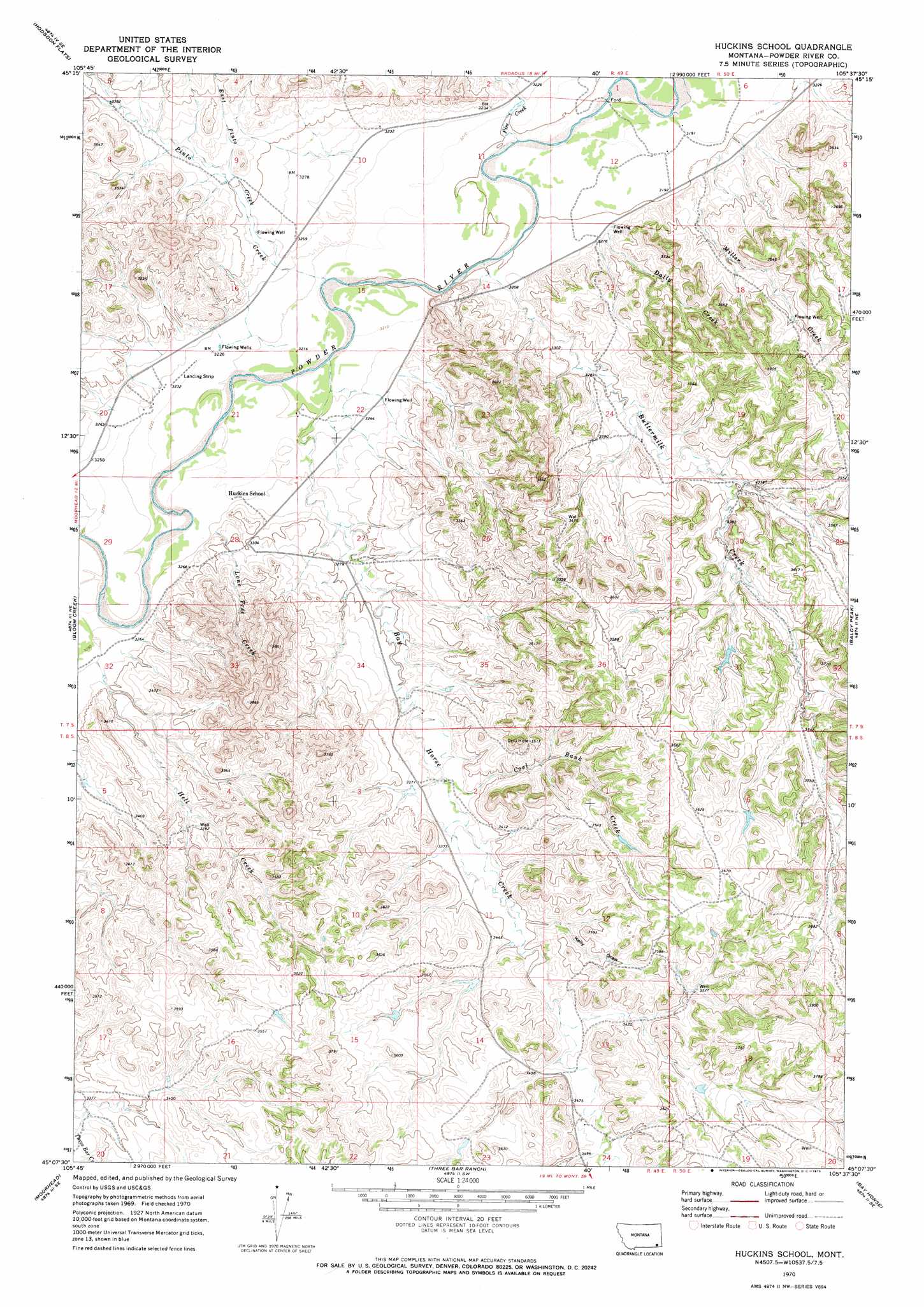
USGS Topo Quad 45105b6 - 1:24,000 scale
| Topo Map Name: | Huckins School |
| USGS Topo Quad ID: | 45105b6 |
| Print Size: | ca. 21 1/4" wide x 27" high |
| Southeast Coordinates: | 45.125° N latitude / 105.625° W longitude |
| Map Center Coordinates: | 45.1875° N latitude / 105.6875° W longitude |
| U.S. State: | MT |
| Filename: | o45105b6.jpg |
| Download Map JPG Image: | Huckins School topo map 1:24,000 scale |
| Map Type: | Topographic |
| Topo Series: | 7.5´ |
| Map Scale: | 1:24,000 |
| Source of Map Images: | United States Geological Survey (USGS) |
| Alternate Map Versions: |
Huckins School MT 1970, updated 1973 Download PDF Buy paper map Huckins School MT 2011 Download PDF Buy paper map Huckins School MT 2014 Download PDF Buy paper map |
1:24,000 Topo Quads surrounding Huckins School
Threemile Buttes |
Sonnette |
Epsie |
Epsie Ne |
Broadus |
Phillips Butte |
Hodsdon Flats |
Yarger Butte |
Lonesome Peak |
Eldon Mountain |
Sayle |
Bloom Creek |
Huckins School |
Baldy Peak |
Bear Skull Mountain |
Bradshaw Creek |
Moorhead |
Three Bar Ranch |
Bay Horse |
Wild Bill Creek |
Black Draw |
Dead Horse Lake |
Corral Creek |
Homestead Draw |
Rocky Butte |
> Back to 45105a1 at 1:100,000 scale
> Back to 45104a1 at 1:250,000 scale
> Back to U.S. Topo Maps home
Huckins School topo map: Gazetteer
Huckins School: Dams
Eureka Reservoir West Dike Dam elevation 1075m 3526′Huckins Number 2 Dam elevation 1074m 3523′
Reder Dam elevation 1075m 3526′
Traub Number 1 Dam elevation 1081m 3546′
Traub Number 2 Dam elevation 1050m 3444′
United States Number 2 Dam elevation 1078m 3536′
Huckins School: Reservoirs
Eureka Reservoir elevation 1075m 3526′Huckins School: Streams
Bay Horse Creek elevation 979m 3211′Buttermilk Creek elevation 976m 3202′
Coal Bank Creek elevation 1019m 3343′
Crooked Creek elevation 1025m 3362′
Daily Creek elevation 984m 3228′
East Pinto Creek elevation 989m 3244′
Fire Creek elevation 973m 3192′
Hell Creek elevation 994m 3261′
Leitner Creek elevation 1003m 3290′
Lone Tree Creek elevation 991m 3251′
Miller Creek elevation 992m 3254′
Pinto Creek elevation 978m 3208′
Tibbets Creek elevation 994m 3261′
Huckins School: Valleys
Ellis Canyon elevation 1049m 3441′Kelly Draw elevation 1036m 3398′
Huckins School: Wells
05N49E14CBBA01 Well elevation 980m 3215′07S49E12AD__01 Well elevation 975m 3198′
07S49E16CDDC01 Well elevation 984m 3228′
07S49E20AD__01 Well elevation 985m 3231′
07S49E20ADCC01 Well elevation 987m 3238′
07S49E21DA__01 Well elevation 984m 3228′
07S49E23CD__01 Well elevation 1032m 3385′
07S49E24DACC01 Well elevation 1023m 3356′
07S49E25BCAD01 Well elevation 1061m 3480′
07S49E27AD__01 Well elevation 1019m 3343′
07S49E28DAAC01 Well elevation 1016m 3333′
07S49E32ACC_01 Well elevation 1000m 3280′
07S49E35CCCB01 Well elevation 1013m 3323′
08S49E04CDBB01 Well elevation 1035m 3395′
08S49E20BD__01 Well elevation 1018m 3339′
08S49E21AA__01 Well elevation 1097m 3599′
Huckins School digital topo map on disk
Buy this Huckins School topo map showing relief, roads, GPS coordinates and other geographical features, as a high-resolution digital map file on DVD:
Eastern Montana & Western North Dakota
Buy digital topo maps: Eastern Montana & Western North Dakota