Monday Creek Topo Map Montana
To zoom in, hover over the map of Monday Creek
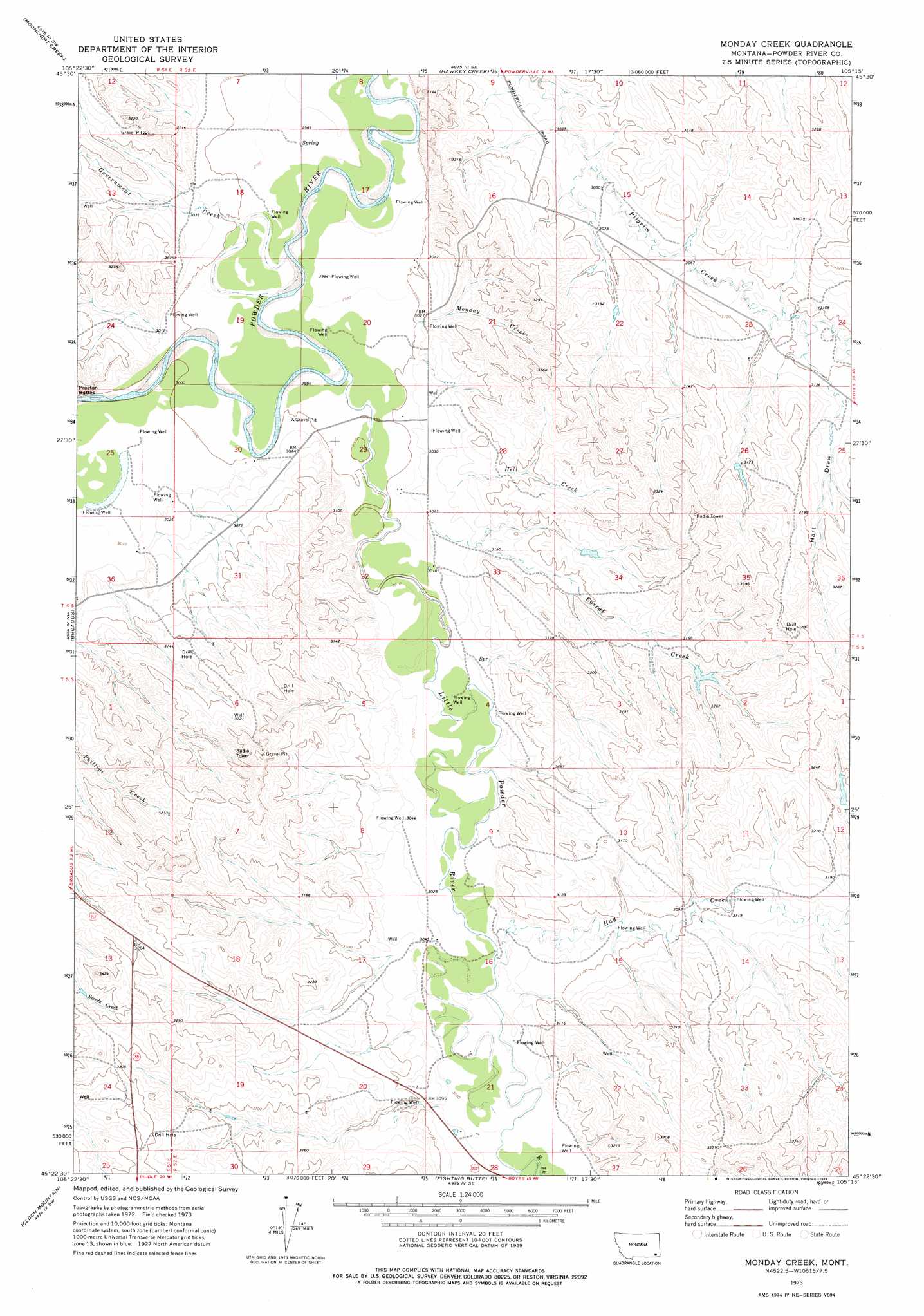
USGS Topo Quad 45105d3 - 1:24,000 scale
| Topo Map Name: | Monday Creek |
| USGS Topo Quad ID: | 45105d3 |
| Print Size: | ca. 21 1/4" wide x 27" high |
| Southeast Coordinates: | 45.375° N latitude / 105.25° W longitude |
| Map Center Coordinates: | 45.4375° N latitude / 105.3125° W longitude |
| U.S. State: | MT |
| Filename: | o45105d3.jpg |
| Download Map JPG Image: | Monday Creek topo map 1:24,000 scale |
| Map Type: | Topographic |
| Topo Series: | 7.5´ |
| Map Scale: | 1:24,000 |
| Source of Map Images: | United States Geological Survey (USGS) |
| Alternate Map Versions: |
Monday Creek MT 1973, updated 1976 Download PDF Buy paper map Monday Creek MT 2011 Download PDF Buy paper map Monday Creek MT 2014 Download PDF Buy paper map |
1:24,000 Topo Quads surrounding Monday Creek
Coalwood |
Johnnie Creek |
Cross S School |
Oliphant Butte |
Rattlesnake Ridge |
Olive |
Moonlight Creek |
Hawkey Creek |
Deer Creek Buttes |
Mckenzie Creek |
Epsie Ne |
Broadus |
Monday Creek |
Little Pilgrim Butte |
Lightning Butte |
Lonesome Peak |
Eldon Mountain |
Fighting Butte |
Dry Creek Butte |
Boyes |
Baldy Peak |
Bear Skull Mountain |
Pine Creek |
Sanburn Reservoir |
Belle Creek North |
> Back to 45105a1 at 1:100,000 scale
> Back to 45104a1 at 1:250,000 scale
> Back to U.S. Topo Maps home
Monday Creek topo map: Gazetteer
Monday Creek: Dams
Turnbull Number 1 Dam elevation 960m 3149′Monday Creek: Streams
Annis Creek elevation 921m 3021′Bobcat Creek elevation 922m 3024′
Butte Creek elevation 937m 3074′
Corral Creek elevation 921m 3021′
Draine Creek elevation 945m 3100′
East Fork Little Powder River elevation 931m 3054′
Government Creek elevation 909m 2982′
Hay Creek elevation 925m 3034′
Hell Creek elevation 928m 3044′
Little Corrall Creek elevation 916m 3005′
Little Powder River elevation 912m 2992′
Little Powder River elevation 912m 2992′
Monday Creek elevation 915m 3001′
Plum Creek elevation 923m 3028′
Monday Creek: Valleys
Dry Gulch elevation 933m 3061′Hart Draw elevation 946m 3103′
Monday Creek: Wells
03S52E18DACB01 Well elevation 910m 2985′04S51E13BDBB01 Well elevation 958m 3143′
04S51E25ACAD01 Well elevation 916m 3005′
04S51E36AC__01 Well elevation 920m 3018′
04S52E15BDCA01 Well elevation 928m 3044′
04S52E17DAAA01 Well elevation 913m 2995′
04S52E18ACD_01 Well elevation 912m 2992′
04S52E18BCDC01 Well elevation 921m 3021′
04S52E20DAAA01 Well elevation 919m 3015′
04S52E21CB__01 Well elevation 946m 3103′
04S52E23ADDB01 Well elevation 945m 3100′
04S52E29BBDD01 Well elevation 913m 2995′
05S52E04DBBC01 Well elevation 961m 3152′
05S52E05ADDA01 Well elevation 918m 3011′
05S52E08AB__01 Well elevation 940m 3083′
05S54E20BB__01 Well elevation 960m 3149′
Monday Creek digital topo map on disk
Buy this Monday Creek topo map showing relief, roads, GPS coordinates and other geographical features, as a high-resolution digital map file on DVD:
Eastern Montana & Western North Dakota
Buy digital topo maps: Eastern Montana & Western North Dakota