Threemile Buttes Topo Map Montana
To zoom in, hover over the map of Threemile Buttes
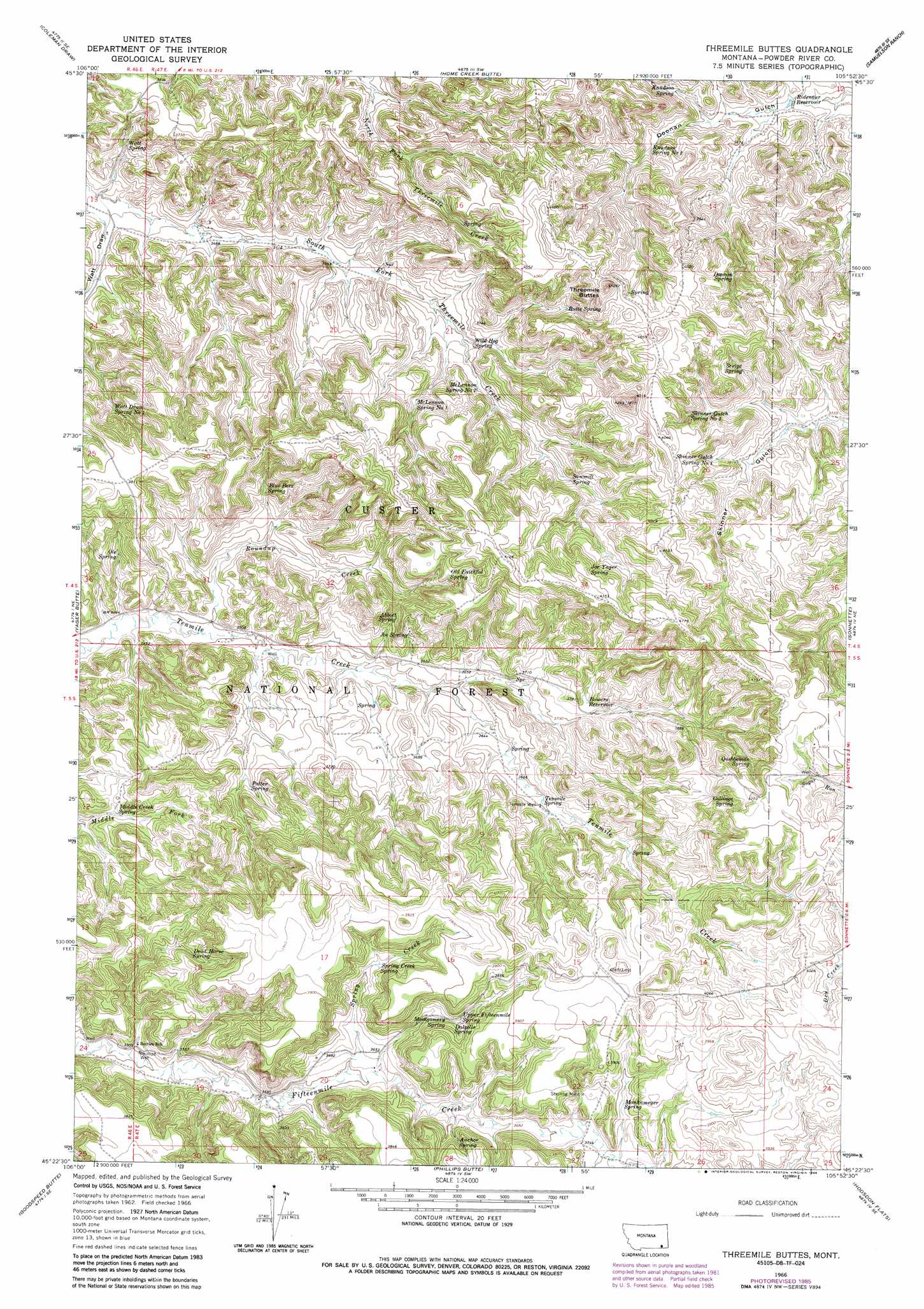
USGS Topo Quad 45105d8 - 1:24,000 scale
| Topo Map Name: | Threemile Buttes |
| USGS Topo Quad ID: | 45105d8 |
| Print Size: | ca. 21 1/4" wide x 27" high |
| Southeast Coordinates: | 45.375° N latitude / 105.875° W longitude |
| Map Center Coordinates: | 45.4375° N latitude / 105.9375° W longitude |
| U.S. State: | MT |
| Filename: | o45105d8.jpg |
| Download Map JPG Image: | Threemile Buttes topo map 1:24,000 scale |
| Map Type: | Topographic |
| Topo Series: | 7.5´ |
| Map Scale: | 1:24,000 |
| Source of Map Images: | United States Geological Survey (USGS) |
| Alternate Map Versions: |
Threemile Buttes MT 1966, updated 1969 Download PDF Buy paper map Threemile Buttes MT 1966, updated 1986 Download PDF Buy paper map Threemile Buttes MT 1995, updated 1998 Download PDF Buy paper map Threemile Buttes MT 2011 Download PDF Buy paper map Threemile Buttes MT 2014 Download PDF Buy paper map |
| FStopo: | US Forest Service topo Threemile Buttes is available: Download FStopo PDF Download FStopo TIF |
1:24,000 Topo Quads surrounding Threemile Buttes
Cook Creek Reservoir |
Beaver Creek School |
Stacey |
Elk Ridge |
Box Elder Creek |
Willow Crossing |
Coleman Draw |
Home Creek Butte |
Samuelson Ranch |
Leslie Creek |
King Mountain |
Yager Butte |
Threemile Buttes |
Sonnette |
Epsie |
Fort Howes |
Goodspeed Butte |
Phillips Butte |
Hodsdon Flats |
Yarger Butte |
Otter |
Reanus Cone |
Sayle |
Bloom Creek |
Huckins School |
> Back to 45105a1 at 1:100,000 scale
> Back to 45104a1 at 1:250,000 scale
> Back to U.S. Topo Maps home
Threemile Buttes topo map: Gazetteer
Threemile Buttes: Mines
Sterling Mine elevation 1142m 3746′Threemile Buttes: Reservoirs
Bowers Reservoir elevation 1139m 3736′Ridenour Reservoir elevation 1110m 3641′
Threemile Buttes: Springs
Abbott Spring elevation 1139m 3736′Anchor Spring elevation 1141m 3743′
Blue Bore Spring elevation 1116m 3661′
Butte Spring elevation 1182m 3877′
Collinge Spring elevation 1224m 4015′
Dalzells Spring elevation 1139m 3736′
Dead Horse Spring elevation 1131m 3710′
Doonan Spring elevation 1167m 3828′
Joe Spring elevation 1126m 3694′
Joe Yager Spring elevation 1233m 4045′
Knudson Spring elevation 1143m 3750′
Knudson Spring Number Two elevation 1144m 3753′
Mankameyer Spring elevation 1151m 3776′
McLennon Spring Number One elevation 1137m 3730′
McLennon Spring Number Two elevation 1126m 3694′
Middle Creek Spring elevation 1077m 3533′
Montgomery Spring elevation 1137m 3730′
Old Faithful Spring elevation 1211m 3973′
Ole Spring elevation 1079m 3540′
Potter Spring elevation 1104m 3622′
Quebbeman Spring elevation 1198m 3930′
Sawmill Spring elevation 1159m 3802′
Script Spring elevation 1193m 3914′
Skinner Gulch Spring Number One elevation 1184m 3884′
Skinner Gulch Spring Number Two elevation 1191m 3907′
Spring Creek Spring elevation 1138m 3733′
Tenmile Spring elevation 1127m 3697′
Upper Fifteenmile Spring elevation 1139m 3736′
Watt Draw Spring Number One elevation 1103m 3618′
Watt Spring elevation 1069m 3507′
Wild Hog Spring elevation 1114m 3654′
Threemile Buttes: Streams
Roundup Creek elevation 1061m 3480′Spring Creek elevation 1096m 3595′
Threemile Buttes: Summits
Threemile Buttes elevation 1297m 4255′Threemile Buttes: Valleys
Watt Draw elevation 1050m 3444′Threemile Buttes: Wells
04S47E12CABD01 Well elevation 1105m 3625′05S47E10BCAB01 Well elevation 1130m 3707′
05S47E19BCBA01 Well elevation 1073m 3520′
Phillips Well elevation 1067m 3500′
Tenmile Well elevation 1128m 3700′
Threemile Buttes digital topo map on disk
Buy this Threemile Buttes topo map showing relief, roads, GPS coordinates and other geographical features, as a high-resolution digital map file on DVD:
Eastern Montana & Western North Dakota
Buy digital topo maps: Eastern Montana & Western North Dakota