Olive Topo Map Montana
To zoom in, hover over the map of Olive
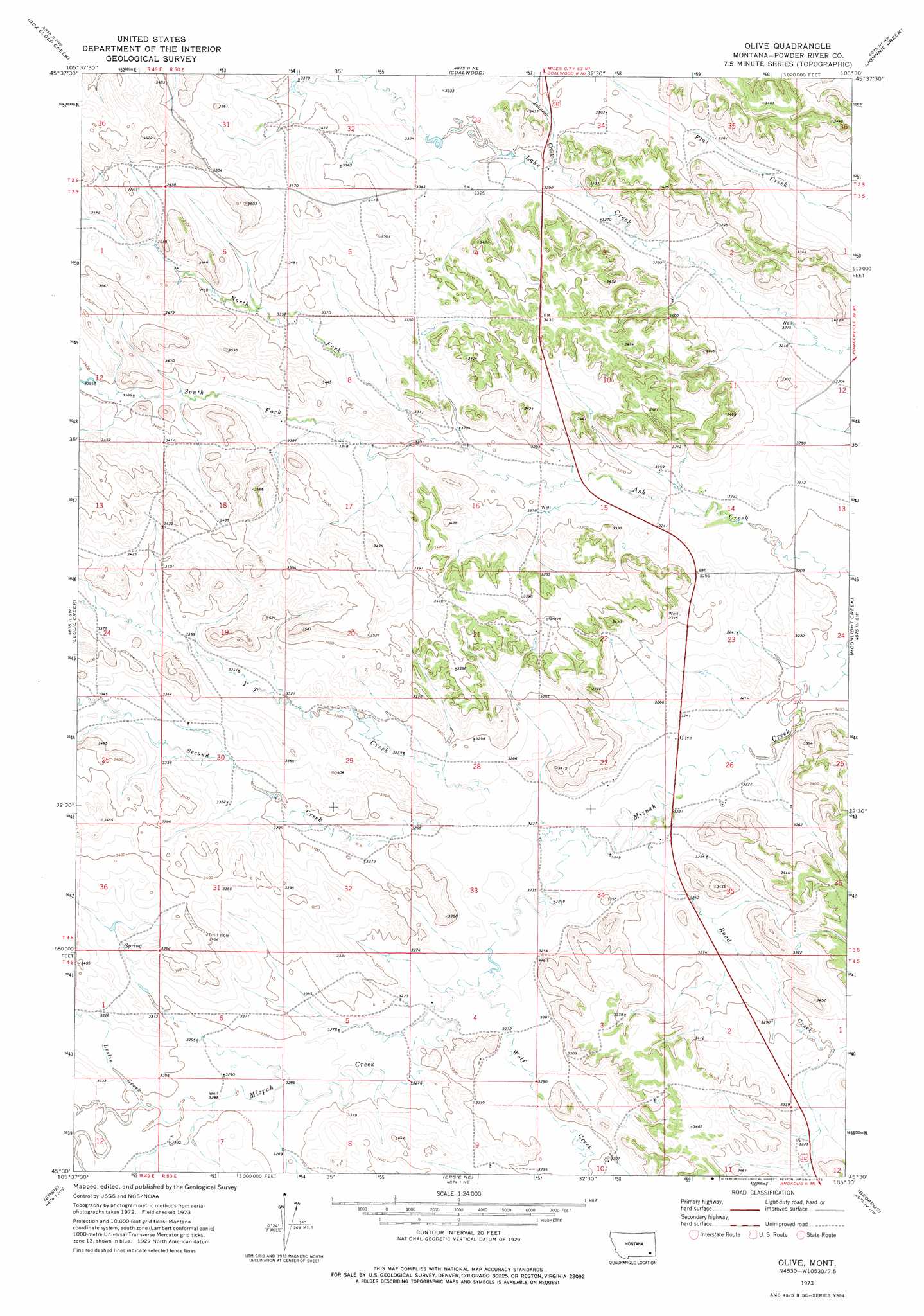
USGS Topo Quad 45105e5 - 1:24,000 scale
| Topo Map Name: | Olive |
| USGS Topo Quad ID: | 45105e5 |
| Print Size: | ca. 21 1/4" wide x 27" high |
| Southeast Coordinates: | 45.5° N latitude / 105.5° W longitude |
| Map Center Coordinates: | 45.5625° N latitude / 105.5625° W longitude |
| U.S. State: | MT |
| Filename: | o45105e5.jpg |
| Download Map JPG Image: | Olive topo map 1:24,000 scale |
| Map Type: | Topographic |
| Topo Series: | 7.5´ |
| Map Scale: | 1:24,000 |
| Source of Map Images: | United States Geological Survey (USGS) |
| Alternate Map Versions: |
Olive MT 1973, updated 1976 Download PDF Buy paper map Olive MT 2011 Download PDF Buy paper map Olive MT 2014 Download PDF Buy paper map |
1:24,000 Topo Quads surrounding Olive
Foster Creek School |
Volborg |
Divide School |
Witcher Reservoir |
Rattlesnake Hill |
Elk Ridge |
Box Elder Creek |
Coalwood |
Johnnie Creek |
Cross S School |
Samuelson Ranch |
Leslie Creek |
Olive |
Moonlight Creek |
Hawkey Creek |
Sonnette |
Epsie |
Epsie Ne |
Broadus |
Monday Creek |
Hodsdon Flats |
Yarger Butte |
Lonesome Peak |
Eldon Mountain |
Fighting Butte |
> Back to 45105e1 at 1:100,000 scale
> Back to 45104a1 at 1:250,000 scale
> Back to U.S. Topo Maps home
Olive topo map: Gazetteer
Olive: Dams
C Smith Number 1 Dam elevation 1003m 3290′Olive: Populated Places
Olive elevation 985m 3231′Olive: Streams
Johnson Creek elevation 1001m 3284′Leslie Creek elevation 1007m 3303′
Middle Creek elevation 1001m 3284′
North Fork Ash Creek elevation 1005m 3297′
Road Creek elevation 982m 3221′
Second Creek elevation 995m 3264′
South Fork Ash Creek elevation 1005m 3297′
Third Creek elevation 1007m 3303′
Wolf Creek elevation 993m 3257′
Y T Creek elevation 993m 3257′
Olive: Wells
02S50E32CDAC01 Well elevation 1033m 3389′02S50E34CCBD01 Well elevation 1015m 3330′
03S49E01AABB01 Well elevation 1061m 3480′
03S49E01ADDB01 Well elevation 1043m 3421′
03S49E12CAAA01 Well elevation 1035m 3395′
03S49E12DACB01 Well elevation 1033m 3389′
03S49E12DBDB01 Well elevation 1034m 3392′
03S49E13DADA01 Well elevation 1045m 3428′
03S50E02CCBC01 Well elevation 1006m 3300′
03S50E03BADD01 Well elevation 998m 3274′
03S50E04BBAC01 Well elevation 1020m 3346′
03S50E05DCCD01 Well elevation 1029m 3375′
03S50E06CBAC01 Well elevation 1042m 3418′
03S50E06CDAB01 Well elevation 1034m 3392′
03S50E06DDCC01 Well elevation 1027m 3369′
03S50E07DDAD01 Well elevation 1019m 3343′
03S50E08BBBA01 Well elevation 1025m 3362′
03S50E08BBBB01 Well elevation 1025m 3362′
03S50E08BBBB02 Well elevation 1025m 3362′
03S50E09CDCA01 Well elevation 1005m 3297′
03S50E15BBAC01 Well elevation 998m 3274′
03S50E15BBAD01 Well elevation 996m 3267′
03S50E15BBBA01 Well elevation 999m 3277′
03S50E15BBBD01 Well elevation 999m 3277′
03S50E15BCBB01 Well elevation 999m 3277′
03S50E15CBBB01 Well elevation 1000m 3280′
03S50E17ABAB01 Well elevation 1009m 3310′
03S50E18AAAB01 Well elevation 1025m 3362′
03S50E21ADDD01 Well elevation 1029m 3375′
03S50E21CDBA01 Well elevation 1034m 3392′
03S50E22CBBB01 Well elevation 1028m 3372′
03S50E26BCBA01 Well elevation 983m 3225′
03S50E26CDAA01 Well elevation 990m 3248′
03S50E30BBDD01 Well elevation 1017m 3336′
03S50E33CCAD01 Well elevation 997m 3270′
03S50E34CBAC01 Well elevation 988m 3241′
04S49E01DCDD01 Well elevation 1007m 3303′
04S50E02ADBD01 Well elevation 1004m 3293′
04S50E03ACDB01 Well elevation 1030m 3379′
04S50E03DDDC01 Well elevation 1027m 3369′
04S50E04AAAA01 Well elevation 999m 3277′
04S50E04BCAC01 Well elevation 995m 3264′
04S50E04DCBA01 Well elevation 1000m 3280′
04S50E04DCBB01 Well elevation 1008m 3307′
04S50E05ADAC01 Well elevation 999m 3277′
04S50E05CAAC01 Well elevation 1001m 3284′
04S50E06CACC01 Well elevation 1005m 3297′
04S50E06DCCC01 Well elevation 1005m 3297′
04S50E07BADA01 Well elevation 1005m 3297′
04S50E07BCCD01 Well elevation 1007m 3303′
04S50E09BBBB01 Well elevation 999m 3277′
04S50E10ACCB01 Well elevation 1010m 3313′
04S50E10ACCC01 Well elevation 1011m 3316′
04S50E10BDAD01 Well elevation 1005m 3297′
Olive digital topo map on disk
Buy this Olive topo map showing relief, roads, GPS coordinates and other geographical features, as a high-resolution digital map file on DVD:
Eastern Montana & Western North Dakota
Buy digital topo maps: Eastern Montana & Western North Dakota