Foster Creek School Topo Map Montana
To zoom in, hover over the map of Foster Creek School
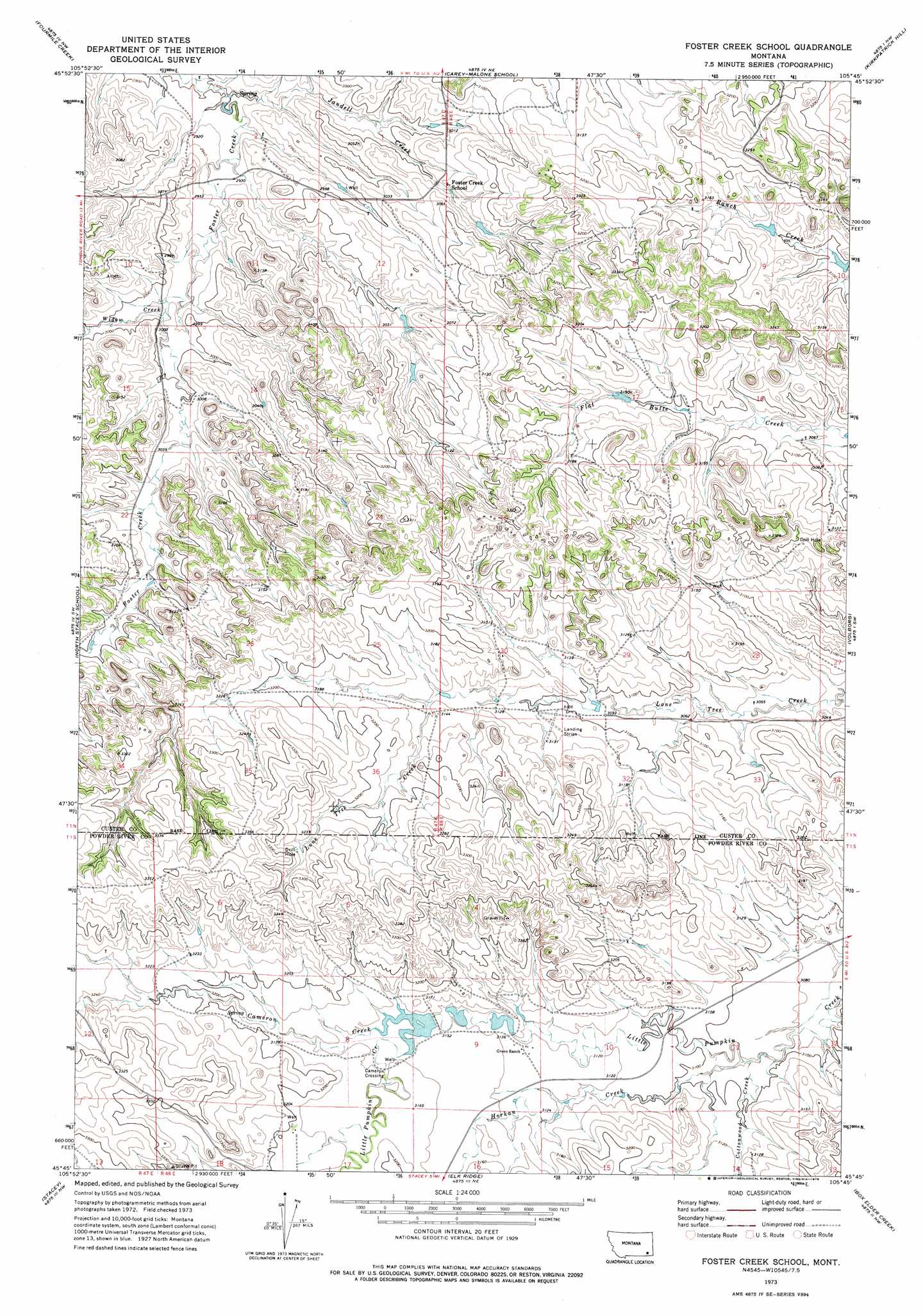
USGS Topo Quad 45105g7 - 1:24,000 scale
| Topo Map Name: | Foster Creek School |
| USGS Topo Quad ID: | 45105g7 |
| Print Size: | ca. 21 1/4" wide x 27" high |
| Southeast Coordinates: | 45.75° N latitude / 105.75° W longitude |
| Map Center Coordinates: | 45.8125° N latitude / 105.8125° W longitude |
| U.S. State: | MT |
| Filename: | o45105g7.jpg |
| Download Map JPG Image: | Foster Creek School topo map 1:24,000 scale |
| Map Type: | Topographic |
| Topo Series: | 7.5´ |
| Map Scale: | 1:24,000 |
| Source of Map Images: | United States Geological Survey (USGS) |
| Alternate Map Versions: |
Foster Creek School MT 1973, updated 1976 Download PDF Buy paper map Foster Creek School MT 2011 Download PDF Buy paper map Foster Creek School MT 2014 Download PDF Buy paper map |
1:24,000 Topo Quads surrounding Foster Creek School
Miller Creek |
Garland School |
Jack Creek |
Beebe Sw |
Beebe |
H S School |
Fourmile Creek |
Carey-Malone School |
Kirkpatrick Hill |
Harris Buttes |
Hayes Point |
North Stacey School |
Foster Creek School |
Volborg |
Divide School |
Beaver Creek School |
Stacey |
Elk Ridge |
Box Elder Creek |
Coalwood |
Coleman Draw |
Home Creek Butte |
Samuelson Ranch |
Leslie Creek |
Olive |
> Back to 45105e1 at 1:100,000 scale
> Back to 45104a1 at 1:250,000 scale
> Back to U.S. Topo Maps home
Foster Creek School topo map: Gazetteer
Foster Creek School: Dams
Green Number 4 Dam elevation 964m 3162′Green Number 5 Dam elevation 957m 3139′
Green Number 6 Dam elevation 958m 3143′
Foster Creek School: Populated Places
Cameron Crossing elevation 964m 3162′Foster Creek School: Streams
Cameron Creek elevation 960m 3149′Cottonwood Creek elevation 940m 3083′
Horkan Creek elevation 940m 3083′
Jandell Creek elevation 885m 2903′
Widow Creek elevation 909m 2982′
Foster Creek School: Wells
01N47E12BAAC01 Well elevation 915m 3001′01N47E23DBDD01 Well elevation 943m 3093′
01N47E27CACD01 Well elevation 952m 3123′
01N47E35ABCC01 Well elevation 988m 3241′
01N48E28CDAD01 Well elevation 930m 3051′
01S48E01ACCC01 Well elevation 947m 3106′
01S48E17BBBC01 Well elevation 980m 3215′
Foster Creek School digital topo map on disk
Buy this Foster Creek School topo map showing relief, roads, GPS coordinates and other geographical features, as a high-resolution digital map file on DVD:
Eastern Montana & Western North Dakota
Buy digital topo maps: Eastern Montana & Western North Dakota