Mills Creek East Topo Map Montana
To zoom in, hover over the map of Mills Creek East
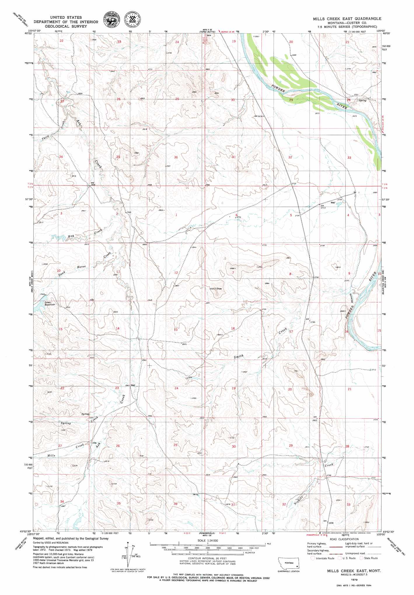
USGS Topo Quad 45105h1 - 1:24,000 scale
| Topo Map Name: | Mills Creek East |
| USGS Topo Quad ID: | 45105h1 |
| Print Size: | ca. 21 1/4" wide x 27" high |
| Southeast Coordinates: | 45.875° N latitude / 105° W longitude |
| Map Center Coordinates: | 45.9375° N latitude / 105.0625° W longitude |
| U.S. State: | MT |
| Filename: | o45105h1.jpg |
| Download Map JPG Image: | Mills Creek East topo map 1:24,000 scale |
| Map Type: | Topographic |
| Topo Series: | 7.5´ |
| Map Scale: | 1:24,000 |
| Source of Map Images: | United States Geological Survey (USGS) |
| Alternate Map Versions: |
Mills Creek East MT 1979, updated 1979 Download PDF Buy paper map Mills Creek East MT 2011 Download PDF Buy paper map Mills Creek East MT 2014 Download PDF Buy paper map |
1:24,000 Topo Quads surrounding Mills Creek East
Mizpah |
Pennock Creek |
Tepee Butte Ne |
Hooky Dam |
Nelson Butte |
Forty Creek |
Bear Jaw Creek |
Tepee Butte |
North Fork Alkali Creek |
Skunk Creek |
Maxwell Butte |
Mills Creek West |
Mills Creek East |
Blacktail Creek Nw |
Board Corral Creek |
Rattlesnake Hill |
Snake Butte |
Powderville |
Blacktail Creek Sw |
Blacktail Creek Se |
Cross S School |
Oliphant Butte |
Rattlesnake Ridge |
Davis Creek West |
Davis Creek East |
> Back to 45105e1 at 1:100,000 scale
> Back to 45104a1 at 1:250,000 scale
> Back to U.S. Topo Maps home
Mills Creek East topo map: Gazetteer
Mills Creek East: Dams
Jones Dam elevation 919m 3015′Mills Creek East: Reservoirs
Jones Reservoir elevation 903m 2962′Mills Creek East: Streams
Dead Horse Creek elevation 876m 2874′May Creek elevation 872m 2860′
Mills Creek elevation 913m 2995′
Smith Creek elevation 815m 2673′
Spring Creek elevation 904m 2965′
Thrid Creek elevation 855m 2805′
Mills Creek East: Wells
02N53E01DACC01 Well elevation 854m 2801′02N53E36ADBD01 Well elevation 889m 2916′
02N54E09DC__01 Well elevation 834m 2736′
02N54E28CAAC01 Well elevation 842m 2762′
02N54E34BBB_02 Well elevation 828m 2716′
02N54E34BBCA01 Well elevation 833m 2732′
03N53E27ACBD01 Well elevation 862m 2828′
03N54E29DDA_01 Well elevation 815m 2673′
04N53E25CCDC01 Well elevation 922m 3024′
Mills Creek East digital topo map on disk
Buy this Mills Creek East topo map showing relief, roads, GPS coordinates and other geographical features, as a high-resolution digital map file on DVD:
Eastern Montana & Western North Dakota
Buy digital topo maps: Eastern Montana & Western North Dakota