Saddle Horse Butte Topo Map Montana
To zoom in, hover over the map of Saddle Horse Butte
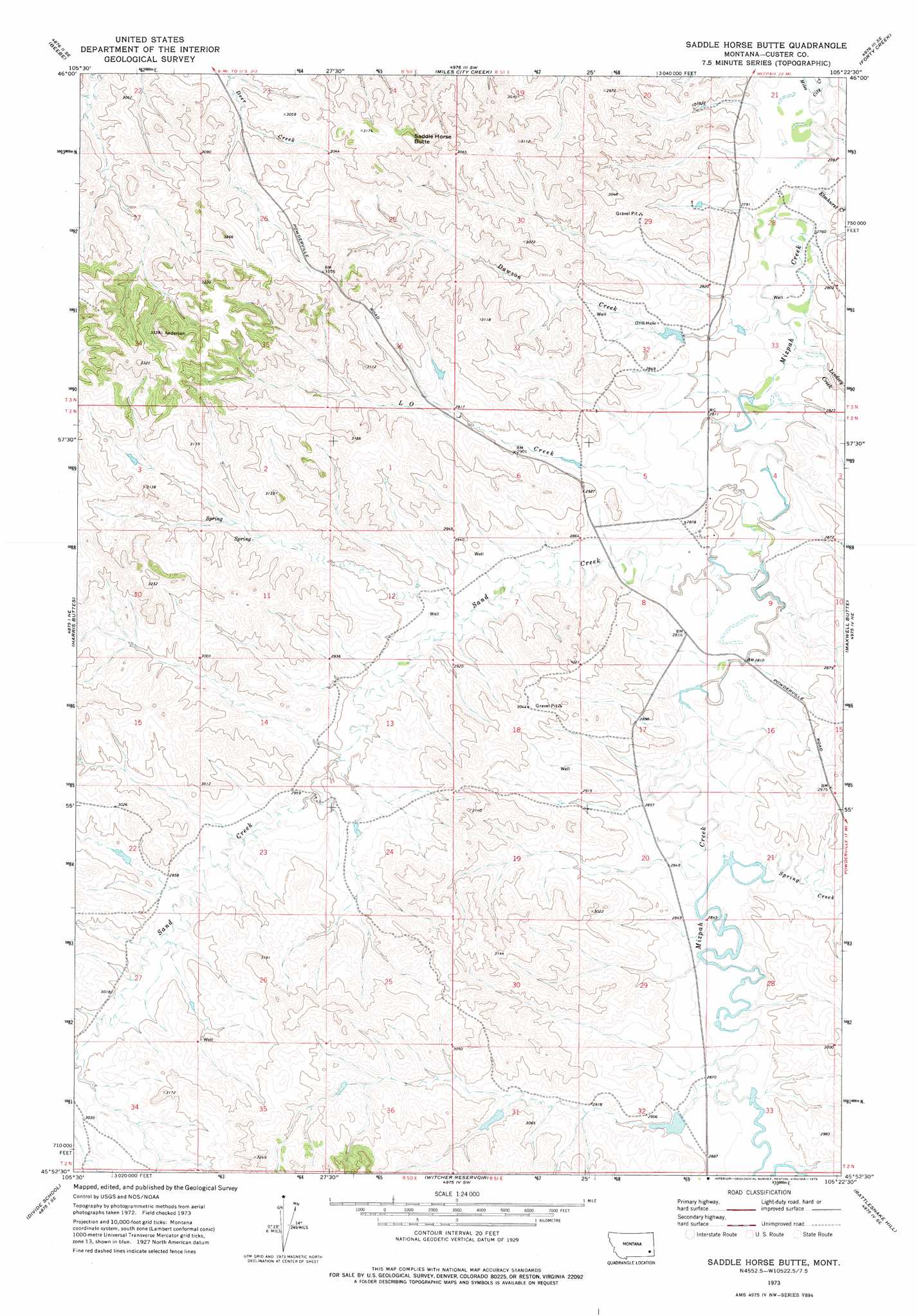
USGS Topo Quad 45105h4 - 1:24,000 scale
| Topo Map Name: | Saddle Horse Butte |
| USGS Topo Quad ID: | 45105h4 |
| Print Size: | ca. 21 1/4" wide x 27" high |
| Southeast Coordinates: | 45.875° N latitude / 105.375° W longitude |
| Map Center Coordinates: | 45.9375° N latitude / 105.4375° W longitude |
| U.S. State: | MT |
| Filename: | o45105h4.jpg |
| Download Map JPG Image: | Saddle Horse Butte topo map 1:24,000 scale |
| Map Type: | Topographic |
| Topo Series: | 7.5´ |
| Map Scale: | 1:24,000 |
| Source of Map Images: | United States Geological Survey (USGS) |
| Alternate Map Versions: |
Saddle Horse Butte MT 1973, updated 1976 Download PDF Buy paper map Saddle Horse Butte MT 2011 Download PDF Buy paper map Saddle Horse Butte MT 2014 Download PDF Buy paper map |
1:24,000 Topo Quads surrounding Saddle Horse Butte
Horse Creek |
First Creek |
Loaf Of Bread Butte |
Mizpah |
Pennock Creek |
Beebe Sw |
Beebe |
Miles City Creek |
Forty Creek |
Bear Jaw Creek |
Kirkpatrick Hill |
Harris Buttes |
Saddle Horse Butte |
Maxwell Butte |
Mills Creek West |
Volborg |
Divide School |
Witcher Reservoir |
Rattlesnake Hill |
Snake Butte |
Box Elder Creek |
Coalwood |
Johnnie Creek |
Cross S School |
Oliphant Butte |
> Back to 45105e1 at 1:100,000 scale
> Back to 45104a1 at 1:250,000 scale
> Back to U.S. Topo Maps home
Saddle Horse Butte topo map: Gazetteer
Saddle Horse Butte: Dams
Fox Dam elevation 882m 2893′Fox Number 1 Dam elevation 903m 2962′
M Hardy Number 3 Dam elevation 857m 2811′
Saddle Horse Butte: Post Offices
Dama Post Office (historical) elevation 855m 2805′Saddle Horse Butte: Streams
Dawson Creek elevation 843m 2765′Elmhurst Creek elevation 837m 2746′
L O Creek elevation 854m 2801′
Lindsey Creek elevation 843m 2765′
Sand Creek elevation 854m 2801′
Spring Creek elevation 866m 2841′
Saddle Horse Butte: Summits
Saddle Horse Butte elevation 991m 3251′Saddle Horse Butte: Wells
02N51E04CCCC01 Well elevation 855m 2805′02N51E18DDBA01 Well elevation 894m 2933′
03N51E32CCCD01 Well elevation 875m 2870′
03S51E18DABB01 Well elevation 927m 3041′
Saddle Horse Butte digital topo map on disk
Buy this Saddle Horse Butte topo map showing relief, roads, GPS coordinates and other geographical features, as a high-resolution digital map file on DVD:
Eastern Montana & Western North Dakota
Buy digital topo maps: Eastern Montana & Western North Dakota