Holmes Ranch Topo Map Montana
To zoom in, hover over the map of Holmes Ranch
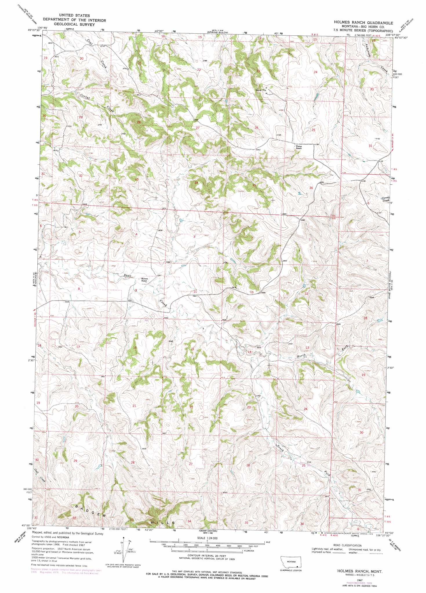
USGS Topo Quad 45106a6 - 1:24,000 scale
| Topo Map Name: | Holmes Ranch |
| USGS Topo Quad ID: | 45106a6 |
| Print Size: | ca. 21 1/4" wide x 27" high |
| Southeast Coordinates: | 45° N latitude / 106.625° W longitude |
| Map Center Coordinates: | 45.0625° N latitude / 106.6875° W longitude |
| U.S. State: | MT |
| Filename: | o45106a6.jpg |
| Download Map JPG Image: | Holmes Ranch topo map 1:24,000 scale |
| Map Type: | Topographic |
| Topo Series: | 7.5´ |
| Map Scale: | 1:24,000 |
| Source of Map Images: | United States Geological Survey (USGS) |
| Alternate Map Versions: |
Holmes Ranch MT 1967, updated 1971 Download PDF Buy paper map Holmes Ranch MT 2011 Download PDF Buy paper map Holmes Ranch MT 2014 Download PDF Buy paper map |
1:24,000 Topo Quads surrounding Holmes Ranch
Kirby |
Taintor Desert |
Birney Sw |
Birney |
Browns Mountain |
Half Moon Hill |
Tongue River Dam |
Spring Gulch |
Lacey Gulch |
Stroud Creek |
Pearl School |
Decker |
Holmes Ranch |
Pine Butte School |
Forks Ranch |
Acme |
Bar N Draw |
Cedar Canyon |
O T O Ranch |
Roundup Draw |
Sheridan |
Wyarno |
Jones Draw |
S R Springs |
Shuler Draw |
> Back to 45106a1 at 1:100,000 scale
> Back to 45106a1 at 1:250,000 scale
> Back to U.S. Topo Maps home
Holmes Ranch topo map: Gazetteer
Holmes Ranch: Springs
09S41E12BDCD01 Spring elevation 1122m 3681′Holmes Ranch: Streams
North Fork Deer Creek elevation 1096m 3595′South Fork Deer Creek elevation 1096m 3595′
South Fork Deer Creek elevation 1096m 3595′
Holmes Ranch: Wells
08S41E21CABB01 Well elevation 1139m 3736′08S41E23DBCA01 Well elevation 1214m 3982′
08S41E24DCBA01 Well elevation 1215m 3986′
08S41E25CCAB01 Well elevation 1271m 4169′
08S41E29BAAC01 Well elevation 1090m 3576′
08S41E32BBBA01 Well elevation 1108m 3635′
08S41E34BCCC01 Well elevation 1120m 3674′
09S41E01CBAC01 Well elevation 1219m 3999′
09S41E01DADD01 Well elevation 1158m 3799′
09S41E05CCDD01 Well elevation 1074m 3523′
09S41E05DCBD01 Well elevation 1082m 3549′
09S41E05DCBD02 Well elevation 1142m 3746′
09S41E05DCBD03 Well elevation 1082m 3549′
09S41E05DCCA01 Well elevation 1079m 3540′
09S41E05DCCA02 Well elevation 1079m 3540′
09S41E06DDCD01 Well elevation 1066m 3497′
09S41E08BBAA01 Well elevation 1065m 3494′
09S41E08BBAD01 Well elevation 1059m 3474′
09S41E08BBDA01 Well elevation 1062m 3484′
09S41E08CABC01 Well elevation 1075m 3526′
09S41E08CABC02 Well elevation 1075m 3526′
09S41E08CACD01 Well elevation 1076m 3530′
09S41E08CBAD01 Well elevation 1073m 3520′
09S41E08CDBD01 Well elevation 1080m 3543′
09S41E09ACBC01 Well elevation 1073m 3520′
09S41E14ACCD01 Well elevation 1096m 3595′
09S41E15ABDB01 Well elevation 1082m 3549′
09S41E17CBCC01 Well elevation 1085m 3559′
09S41E20DDDD01 Well elevation 1138m 3733′
09S41E26AADA01 Well elevation 1120m 3674′
09S41E26ABBB01 Well elevation 1146m 3759′
09S41E26BABC01 Well elevation 1147m 3763′
09S41E35DADD01 Well elevation 1164m 3818′
09S42E31CBAC01 Well elevation 1139m 3736′
10S42E06ABDD01 Well elevation 1158m 3799′
Holmes Ranch digital topo map on disk
Buy this Holmes Ranch topo map showing relief, roads, GPS coordinates and other geographical features, as a high-resolution digital map file on DVD:
Eastern Montana & Western North Dakota
Buy digital topo maps: Eastern Montana & Western North Dakota