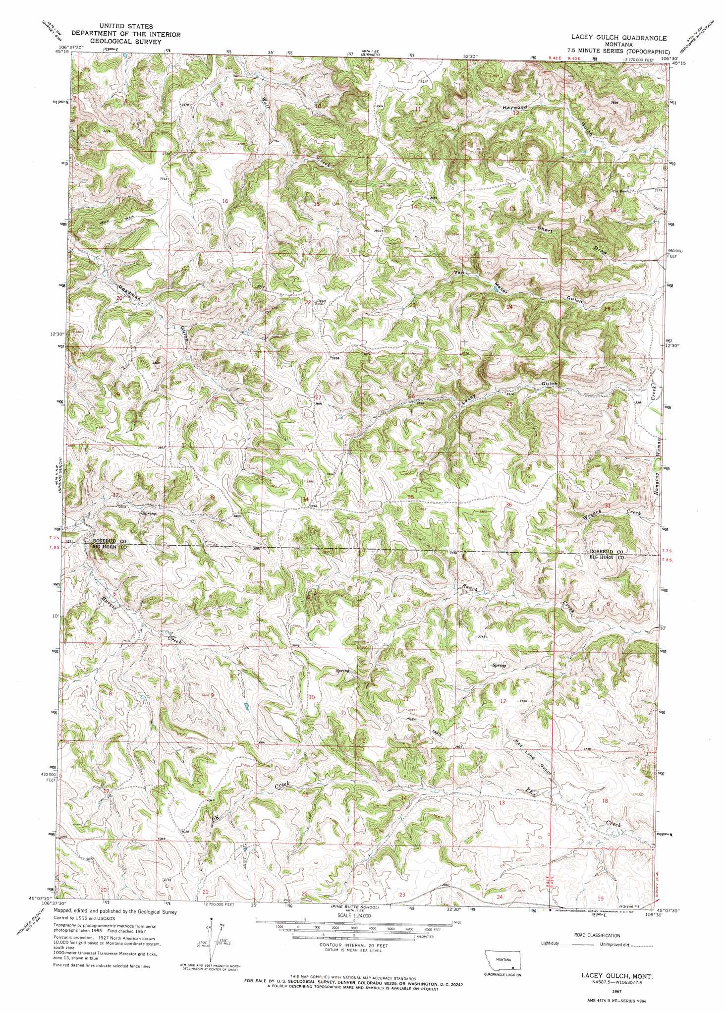
Lacey Gulch Topo Map Montana
To zoom in, hover over the map of Lacey Gulch
USGS Topo Quad 45106b5 - 1:24,000 scale
| Topo Map Name: | Lacey Gulch |
| USGS Topo Quad ID: | 45106b5 |
| Print Size: | ca. 21 1/4" wide x 27" high |
| Southeast Coordinates: | 45.125° N latitude / 106.5° W longitude |
| Map Center Coordinates: | 45.1875° N latitude / 106.5625° W longitude |
| U.S. State: | MT |
| Filename: | o45106b5.jpg |
| Download Map JPG Image: | Lacey Gulch topo map 1:24,000 scale |
| Map Type: | Topographic |
| Topo Series: | 7.5´ |
| Map Scale: | 1:24,000 |
| Source of Map Images: | United States Geological Survey (USGS) |
| Alternate Map Versions: |
Lacey Gulch MT 1967, updated 1971 Download PDF Buy paper map Lacey Gulch MT 2011 Download PDF Buy paper map Lacey Gulch MT 2014 Download PDF Buy paper map |
1:24,000 Topo Quads surrounding Lacey Gulch
Bull Creek Lookout |
Cook Creek Butte |
Clubfoot Creek |
Birney Day School |
Green Creek |
Taintor Desert |
Birney Sw |
Birney |
Browns Mountain |
Poker Jim Butte |
Tongue River Dam |
Spring Gulch |
Lacey Gulch |
Stroud Creek |
Hamilton Draw |
Decker |
Holmes Ranch |
Pine Butte School |
Forks Ranch |
Quietus |
Bar N Draw |
Cedar Canyon |
O T O Ranch |
Roundup Draw |
Box Elder Draw |
> Back to 45106a1 at 1:100,000 scale
> Back to 45106a1 at 1:250,000 scale
> Back to U.S. Topo Maps home
Lacey Gulch topo map: Gazetteer
Lacey Gulch: Springs
08S42E10AADC01 Spring elevation 1183m 3881′08S42E16DDDC01 Spring elevation 1201m 3940′
Lacey Gulch: Valleys
Bad Land Gulch elevation 1095m 3592′Lacey Gulch elevation 1025m 3362′
Short Draw elevation 1011m 3316′
Van Meter Gulch elevation 1016m 3333′
Lacey Gulch: Wells
07S42E20CAAA01 Well elevation 1075m 3526′08S42E02ADDD01 Well elevation 1102m 3615′
08S42E09AACC01 Well elevation 1153m 3782′
08S42E14ADCB01 Well elevation 1123m 3684′
08S42E14DBAD01 Well elevation 1140m 3740′
08S42E14DBAD02 Well elevation 1140m 3740′
08S42E15CBBA01 Well elevation 1171m 3841′
08S42E21AAAB01 Well elevation 1206m 3956′
08S42E22CAAC01 Well elevation 1215m 3986′
08S42E23BDBC01 Well elevation 1182m 3877′
08S43E07ADAA01 Well elevation 1105m 3625′
Lacey Gulch digital topo map on disk
Buy this Lacey Gulch topo map showing relief, roads, GPS coordinates and other geographical features, as a high-resolution digital map file on DVD:
Eastern Montana & Western North Dakota
Buy digital topo maps: Eastern Montana & Western North Dakota