Birdseye Spring Topo Map Montana
To zoom in, hover over the map of Birdseye Spring
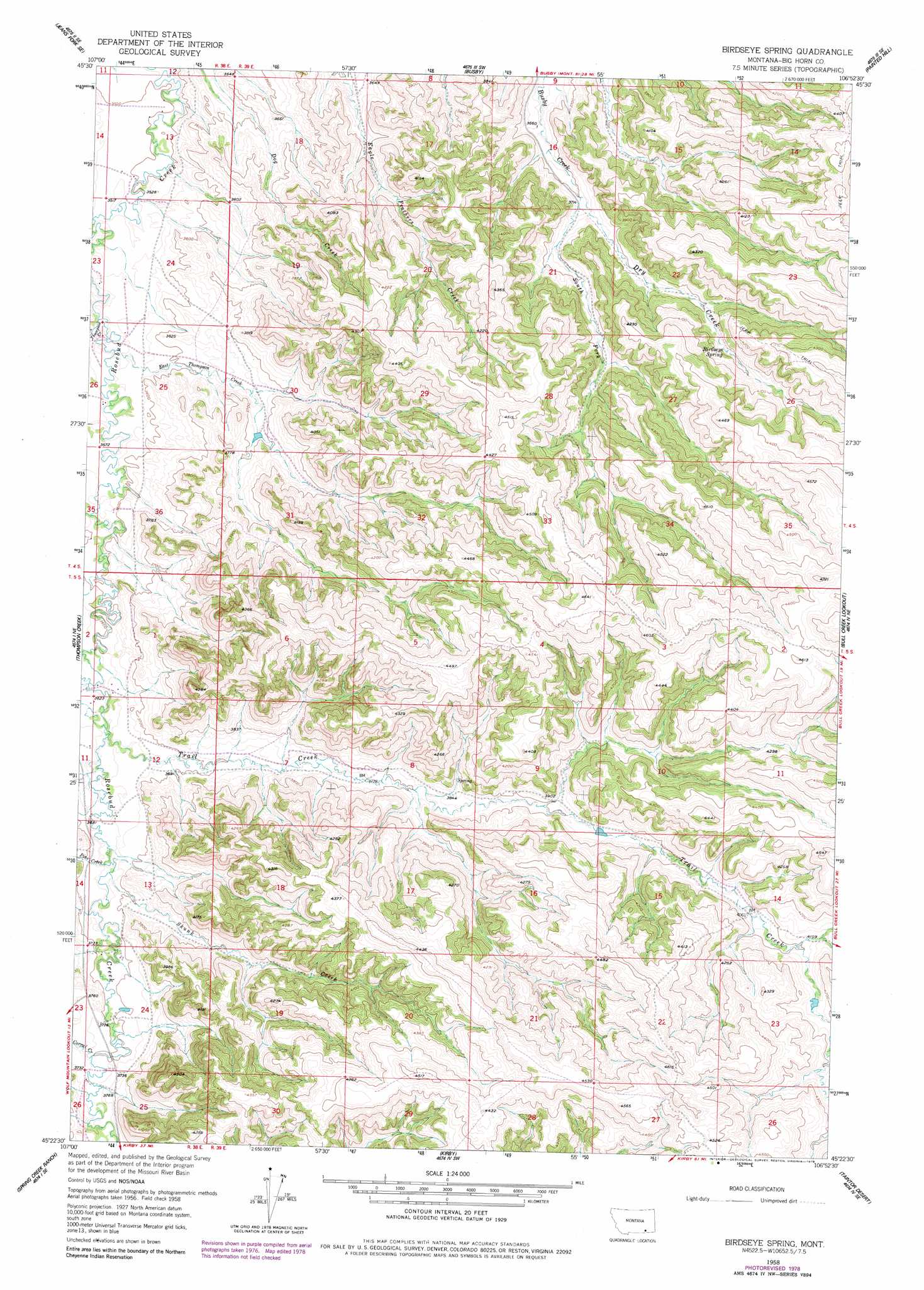
USGS Topo Quad 45106d8 - 1:24,000 scale
| Topo Map Name: | Birdseye Spring |
| USGS Topo Quad ID: | 45106d8 |
| Print Size: | ca. 21 1/4" wide x 27" high |
| Southeast Coordinates: | 45.375° N latitude / 106.875° W longitude |
| Map Center Coordinates: | 45.4375° N latitude / 106.9375° W longitude |
| U.S. State: | MT |
| Filename: | o45106d8.jpg |
| Download Map JPG Image: | Birdseye Spring topo map 1:24,000 scale |
| Map Type: | Topographic |
| Topo Series: | 7.5´ |
| Map Scale: | 1:24,000 |
| Source of Map Images: | United States Geological Survey (USGS) |
| Alternate Map Versions: |
Birdseye Spring MT 1958, updated 1960 Download PDF Buy paper map Birdseye Spring MT 1958, updated 1978 Download PDF Buy paper map Birdseye Spring MT 2011 Download PDF Buy paper map Birdseye Spring MT 2014 Download PDF Buy paper map |
1:24,000 Topo Quads surrounding Birdseye Spring
Jeans Fork Nw |
Jeans Fork Ne |
Chalky Point |
Black Spring |
Jimtown |
Jeans Fork Sw |
Jeans Fork Se |
Busby |
Painted Hill |
Lame Deer |
Thompson Creek Nw |
Thompson Creek |
Birdseye Spring |
Bull Creek Lookout |
Cook Creek Butte |
Wolf Mountain Lookout |
Spring Creek Ranch |
Kirby |
Taintor Desert |
Birney Sw |
Kid Creek |
Bar V Ranch Ne |
Half Moon Hill |
Tongue River Dam |
Spring Gulch |
> Back to 45106a1 at 1:100,000 scale
> Back to 45106a1 at 1:250,000 scale
> Back to U.S. Topo Maps home
Birdseye Spring topo map: Gazetteer
Birdseye Spring: Post Offices
Hutton Post Office (historical) elevation 1131m 3710′Birdseye Spring: Springs
Birdseye Spring elevation 1202m 3943′Birdseye Spring: Streams
Corral Creek elevation 1133m 3717′Dry Creek elevation 1128m 3700′
East Thompson Creek elevation 1078m 3536′
Pine Creek elevation 1119m 3671′
Skunk Creek elevation 1121m 3677′
South Fork Busby Creek elevation 1133m 3717′
Thompson Creek elevation 1067m 3500′
Trail Creek elevation 1112m 3648′
Wolf Creek elevation 1087m 3566′
Birdseye Spring: Wells
04S38E13ABBC01 Well elevation 1044m 3425′04S38E36BCBA01 Well elevation 1085m 3559′
04S38E36BCBB01 Well elevation 1088m 3569′
04S38E36BCBD01 Well elevation 1084m 3556′
04S39E16BDBD01 Well elevation 1109m 3638′
05S39E07ACDD01 Well elevation 1147m 3763′
Birdseye Spring digital topo map on disk
Buy this Birdseye Spring topo map showing relief, roads, GPS coordinates and other geographical features, as a high-resolution digital map file on DVD:
Eastern Montana & Western North Dakota
Buy digital topo maps: Eastern Montana & Western North Dakota