Beaver Creek School Topo Map Montana
To zoom in, hover over the map of Beaver Creek School
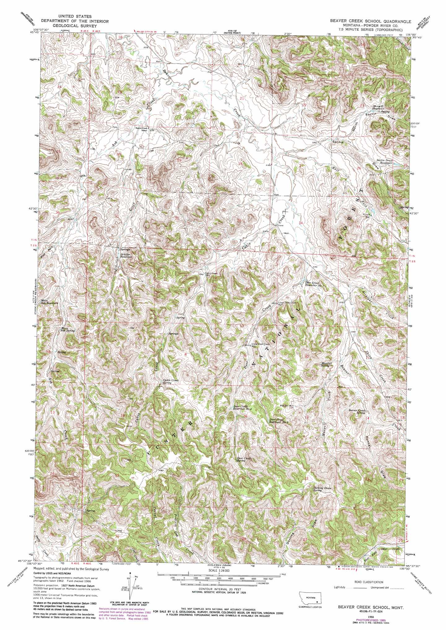
USGS Topo Quad 45106f1 - 1:24,000 scale
| Topo Map Name: | Beaver Creek School |
| USGS Topo Quad ID: | 45106f1 |
| Print Size: | ca. 21 1/4" wide x 27" high |
| Southeast Coordinates: | 45.625° N latitude / 106° W longitude |
| Map Center Coordinates: | 45.6875° N latitude / 106.0625° W longitude |
| U.S. State: | MT |
| Filename: | o45106f1.jpg |
| Download Map JPG Image: | Beaver Creek School topo map 1:24,000 scale |
| Map Type: | Topographic |
| Topo Series: | 7.5´ |
| Map Scale: | 1:24,000 |
| Source of Map Images: | United States Geological Survey (USGS) |
| Alternate Map Versions: |
Beaver Creek School MT 1966, updated 1969 Download PDF Buy paper map Beaver Creek School MT 1966, updated 1980 Download PDF Buy paper map Beaver Creek School MT 1966, updated 1986 Download PDF Buy paper map Beaver Creek School MT 1995, updated 1998 Download PDF Buy paper map Beaver Creek School MT 2011 Download PDF Buy paper map Beaver Creek School MT 2014 Download PDF Buy paper map |
| FStopo: | US Forest Service topo Beaver Creek School is available: Download FStopo PDF Download FStopo TIF |
1:24,000 Topo Quads surrounding Beaver Creek School
John Hen Creek |
Brandenberg Nw |
H S School |
Fourmile Creek |
Carey-Malone School |
Hammond Draw |
Brandenberg |
Hayes Point |
North Stacey School |
Foster Creek School |
Ashland Ne |
Cook Creek Reservoir |
Beaver Creek School |
Stacey |
Elk Ridge |
Ashland |
Willow Crossing |
Coleman Draw |
Home Creek Butte |
Samuelson Ranch |
Green Creek |
King Mountain |
Yager Butte |
Threemile Buttes |
Sonnette |
> Back to 45106e1 at 1:100,000 scale
> Back to 45106a1 at 1:250,000 scale
> Back to U.S. Topo Maps home
Beaver Creek School topo map: Gazetteer
Beaver Creek School: Reservoirs
Deer Creek Reservoir Number One elevation 1001m 3284′Deer Creek Reservoir Number Three elevation 1108m 3635′
Deer Creek Reservoir Number Two elevation 1077m 3533′
Main Ash Reservoir elevation 1031m 3382′
Sartin Draw Reservoir elevation 1034m 3392′
Sawmill Reservoir elevation 1027m 3369′
Schiller Reservoir elevation 1001m 3284′
Beaver Creek School: Springs
02S46E08CCCD01 Spring elevation 1089m 3572′02S46E10DBDA01 Spring elevation 1072m 3517′
02S46E17BACA01 Spring elevation 1105m 3625′
02S46E22DBCA01 Spring elevation 1205m 3953′
Beaver Creek Spring elevation 1068m 3503′
Cabin Creek Spring elevation 1082m 3549′
Darling Draw Spring elevation 1198m 3930′
Deer Creek Spring elevation 1127m 3697′
Main Ash Spring elevation 1034m 3392′
Maxwell Spring elevation 1061m 3480′
Beaver Creek School: Streams
Ash Creek elevation 940m 3083′Cabin Creek elevation 976m 3202′
Deer Creek elevation 989m 3244′
East Fork Beaver Creek elevation 966m 3169′
Maxwell Creek elevation 1043m 3421′
North Fork Beaver Creek elevation 968m 3175′
Schiller Creek elevation 951m 3120′
Sheep Creek elevation 1028m 3372′
Straight Creek elevation 1014m 3326′
West Fork Ash Creek elevation 991m 3251′
Beaver Creek School: Valleys
Funnel Draw elevation 1081m 3546′North Sartin Draw elevation 996m 3267′
Sartin Draw elevation 976m 3202′
Beaver Creek School: Wells
01S45E25DDCA01 Well elevation 979m 3211′01S45E36DABC01 Well elevation 989m 3244′
01S46E21DCBC01 Well elevation 957m 3139′
01S46E27BCBC01 Well elevation 977m 3205′
01S46E28ADDD01 Well elevation 971m 3185′
01S46E28BAAB01 Well elevation 962m 3156′
01S46E29BBDA01 Well elevation 971m 3185′
01S46E30ADCA01 Well elevation 964m 3162′
01S46E30ADCA02 Well elevation 964m 3162′
01S46E30DBDC01 Well elevation 972m 3188′
01S46E33DADB01 Well elevation 994m 3261′
01S46E34CBDA01 Well elevation 994m 3261′
02S46E02DBBB01 Well elevation 1031m 3382′
02S46E03CA__01 Well elevation 1025m 3362′
02S46E05AACB01 Well elevation 1026m 3366′
02S46E09ACBD01 Well elevation 1048m 3438′
02S46E15BDBC01 Well elevation 1094m 3589′
Cabin Creek Well elevation 1026m 3366′
Lower Deer Creek Well elevation 1025m 3362′
Maxwell Well elevation 1093m 3585′
Upper Deer Creek Well elevation 1049m 3441′
Beaver Creek School digital topo map on disk
Buy this Beaver Creek School topo map showing relief, roads, GPS coordinates and other geographical features, as a high-resolution digital map file on DVD:
Eastern Montana & Western North Dakota
Buy digital topo maps: Eastern Montana & Western North Dakota