Badger Peak Topo Map Montana
To zoom in, hover over the map of Badger Peak
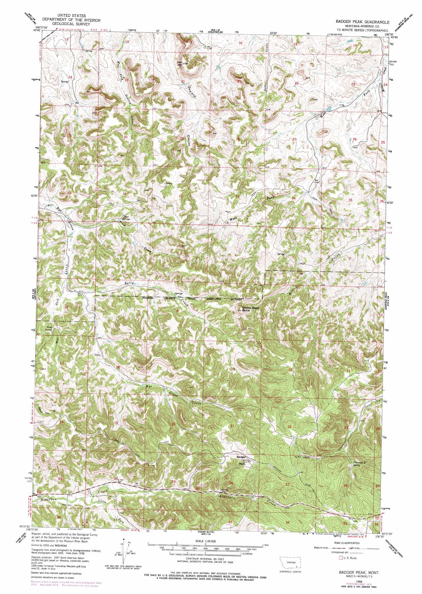
USGS Topo Quad 45106f5 - 1:24,000 scale
| Topo Map Name: | Badger Peak |
| USGS Topo Quad ID: | 45106f5 |
| Print Size: | ca. 21 1/4" wide x 27" high |
| Southeast Coordinates: | 45.625° N latitude / 106.5° W longitude |
| Map Center Coordinates: | 45.6875° N latitude / 106.5625° W longitude |
| U.S. State: | MT |
| Filename: | o45106f5.jpg |
| Download Map JPG Image: | Badger Peak topo map 1:24,000 scale |
| Map Type: | Topographic |
| Topo Series: | 7.5´ |
| Map Scale: | 1:24,000 |
| Source of Map Images: | United States Geological Survey (USGS) |
| Alternate Map Versions: |
Badger Peak MT 1958, updated 1960 Download PDF Buy paper map Badger Peak MT 2011 Download PDF Buy paper map Badger Peak MT 2014 Download PDF Buy paper map |
1:24,000 Topo Quads surrounding Badger Peak
Trail Creek School |
Colstrip West |
Colstrip East |
Hammond Draw Nw |
John Hen Creek |
Rough Draw |
Colstrip Sw |
Colstrip Se |
Hammond Draw Sw |
Hammond Draw |
Black Spring |
Jimtown |
Badger Peak |
Garfield Peak |
Ashland Ne |
Painted Hill |
Lame Deer |
Fisher Butte |
Hollowwood Creek |
Ashland |
Bull Creek Lookout |
Cook Creek Butte |
Clubfoot Creek |
Birney Day School |
Green Creek |
> Back to 45106e1 at 1:100,000 scale
> Back to 45106a1 at 1:250,000 scale
> Back to U.S. Topo Maps home
Badger Peak topo map: Gazetteer
Badger Peak: Springs
01S42E26DBAB01 Spring elevation 984m 3228′02S42E03BDCD01 Spring elevation 1067m 3500′
02S42E04ADCB01 Spring elevation 1078m 3536′
08S42E21AAAC01 Spring elevation 1155m 3789′
Diamond R Spring elevation 1247m 4091′
Mud Springs elevation 1038m 3405′
Wood Spring elevation 1069m 3507′
Badger Peak: Streams
Kelly Creek elevation 1045m 3428′South Fork Alderson Creek elevation 1091m 3579′
West Fork Miller Creek elevation 950m 3116′
West Fork Ryegrass Creek elevation 1034m 3392′
Badger Peak: Summits
Badger Peak elevation 1344m 4409′Charlie Black Butte elevation 1302m 4271′
Badger Peak: Valleys
Mud Draw elevation 1002m 3287′Badger Peak: Wells
01S42E23CDCA01 Well elevation 967m 3172′01S42E26DBDA01 Well elevation 983m 3225′
01S42E27CBBC01 Well elevation 997m 3270′
01S42E34AADA01 Well elevation 1002m 3287′
01S42E35CBBC01 Well elevation 1024m 3359′
02S41E12ABD_01 Well elevation 1043m 3421′
02S42E01BBBC01 Well elevation 1031m 3382′
02S42E02BDCA01 Well elevation 1063m 3487′
02S42E18BCA_01 Well elevation 1092m 3582′
02S42E27ABA_01 Well elevation 1294m 4245′
02S42E30CBA_01 Well elevation 1115m 3658′
02S42E30CCB_01 Well elevation 1094m 3589′
Badger Peak digital topo map on disk
Buy this Badger Peak topo map showing relief, roads, GPS coordinates and other geographical features, as a high-resolution digital map file on DVD:
Eastern Montana & Western North Dakota
Buy digital topo maps: Eastern Montana & Western North Dakota