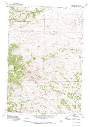
Rough Draw Topo Map Montana
To zoom in, hover over the map of Rough Draw
USGS Topo Quad 45106g7 - 1:24,000 scale
| Topo Map Name: | Rough Draw |
| USGS Topo Quad ID: | 45106g7 |
| Print Size: | ca. 21 1/4" wide x 27" high |
| Southeast Coordinates: | 45.75° N latitude / 106.75° W longitude |
| Map Center Coordinates: | 45.8125° N latitude / 106.8125° W longitude |
| U.S. State: | MT |
| Filename: | o45106g7.jpg |
| Download Map JPG Image: | Rough Draw topo map 1:24,000 scale |
| Map Type: | Topographic |
| Topo Series: | 7.5´ |
| Map Scale: | 1:24,000 |
| Source of Map Images: | United States Geological Survey (USGS) |
| Alternate Map Versions: |
Rough Draw MT 1971, updated 1974 Download PDF Buy paper map Rough Draw MT 2011 Download PDF Buy paper map Rough Draw MT 2014 Download PDF Buy paper map |
1:24,000 Topo Quads surrounding Rough Draw
> Back to 45106e1 at 1:100,000 scale
> Back to 45106a1 at 1:250,000 scale
> Back to U.S. Topo Maps home
Rough Draw topo map: Gazetteer
Rough Draw: Post Offices
Castle Rock Post Office (historical) elevation 1080m 3543′Rough Draw: Springs
01N39E22DDDC01 Spring elevation 1217m 3992′01N40E19DCCD01 Spring elevation 1105m 3625′
01N40E19DCCD01 Spring elevation 1120m 3674′
01N40E20DADC01 Spring elevation 1073m 3520′
01N40E30ABBC01 Spring elevation 1108m 3635′
01N40E31DBDA01 Spring elevation 1124m 3687′
01S39E12DCBA01 Spring elevation 1152m 3779′
01S40E06BBDB01 Spring elevation 1184m 3884′
01S40E07CBCD01 Spring elevation 1122m 3681′
01S40E08AAAC01 Spring elevation 1122m 3681′
Rough Draw: Valleys
Rough Draw elevation 1067m 3500′Rough Draw: Wells
01N39E01BBBA01 Well elevation 1056m 3464′01N39E11ADAD01 Well elevation 1169m 3835′
01N39E12CCCC01 Well elevation 1138m 3733′
01N39E22DDD_01 Well elevation 1219m 3999′
01N39E23CAAA01 Well elevation 1190m 3904′
01N39E24BBBC01 Well elevation 1167m 3828′
01N39E24BBBC01 Well elevation 1166m 3825′
01N39E26ABBB01 Well elevation 1215m 3986′
01N40E04DADA01 Well elevation 1069m 3507′
01N40E05ABBB01 Well elevation 1049m 3441′
01N40E05DBBB01 Well elevation 1068m 3503′
01N40E05DBBB02 Well elevation 1068m 3503′
01N40E05DBBB03 Well elevation 1068m 3503′
01N40E06B___01 Well elevation 1086m 3562′
01N40E07BCBB01 Well elevation 1133m 3717′
01N40E07CCCD01 Well elevation 1149m 3769′
01N40E15BBCB01 Well elevation 1062m 3484′
01N40E16AADA01 Well elevation 1062m 3484′
01N40E16DBAA01 Well elevation 1074m 3523′
01N40E16DDBD01 Well elevation 1099m 3605′
01N40E17BBBC01 Well elevation 1103m 3618′
01N40E17BBBC02 Well elevation 1103m 3618′
01N40E18ABBB01 Well elevation 1108m 3635′
01N40E18BABA01 Well elevation 1106m 3628′
01N40E18DDCA01 Well elevation 1114m 3654′
01N40E21AAAD01 Well elevation 1082m 3549′
01N40E28ADDD01 Well elevation 1042m 3418′
01N40E29ABCC01 Well elevation 1084m 3556′
01N40E29ACBB01 Well elevation 1081m 3546′
01S40E05CDAD01 Well elevation 1116m 3661′
01S40E06DAAD01 Well elevation 1155m 3789′
01S40E07DADA01 Well elevation 1093m 3585′
01S40E09DADB01 Well elevation 1063m 3487′
01S40E16DABD01 Well elevation 1039m 3408′
01S41E02AABB01 Well elevation 1099m 3605′
Rough Draw digital topo map on disk
Buy this Rough Draw topo map showing relief, roads, GPS coordinates and other geographical features, as a high-resolution digital map file on DVD:
Eastern Montana & Western North Dakota
Buy digital topo maps: Eastern Montana & Western North Dakota


