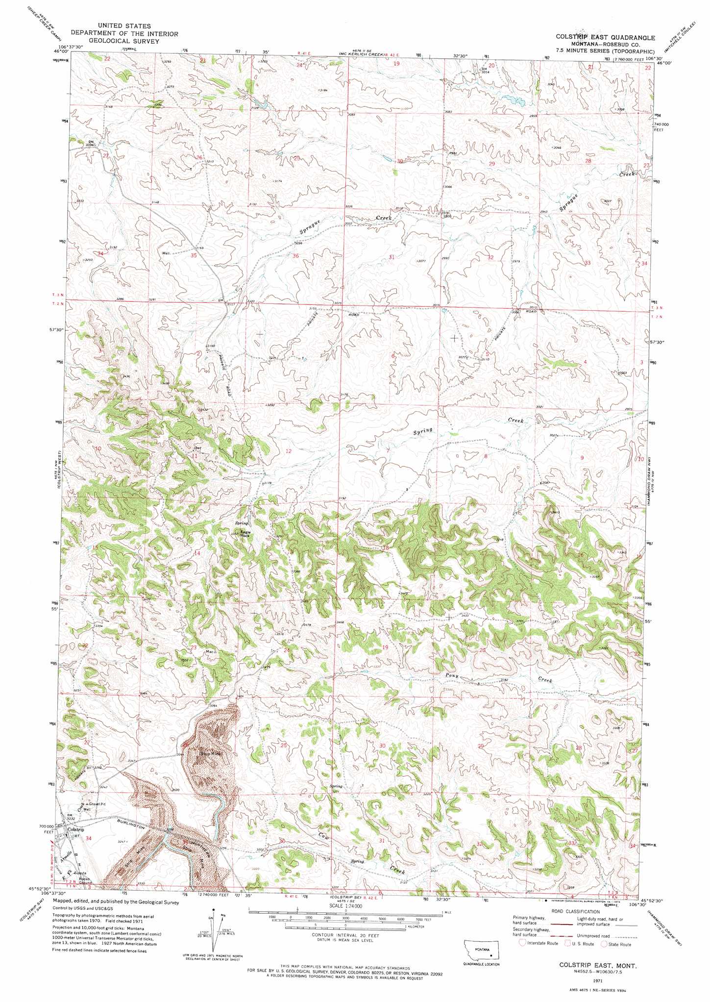
Colstrip East Topo Map Montana
To zoom in, hover over the map of Colstrip East
USGS Topo Quad 45106h5 - 1:24,000 scale
| Topo Map Name: | Colstrip East |
| USGS Topo Quad ID: | 45106h5 |
| Print Size: | ca. 21 1/4" wide x 27" high |
| Southeast Coordinates: | 45.875° N latitude / 106.5° W longitude |
| Map Center Coordinates: | 45.9375° N latitude / 106.5625° W longitude |
| U.S. State: | MT |
| Filename: | o45106h5.jpg |
| Download Map JPG Image: | Colstrip East topo map 1:24,000 scale |
| Map Type: | Topographic |
| Topo Series: | 7.5´ |
| Map Scale: | 1:24,000 |
| Source of Map Images: | United States Geological Survey (USGS) |
| Alternate Map Versions: |
Colstrip East MT 1971, updated 1974 Download PDF Buy paper map Colstrip East MT 2011 Download PDF Buy paper map Colstrip East MT 2014 Download PDF Buy paper map |
1:24,000 Topo Quads surrounding Colstrip East
Griffin Coulee Ne |
Smith Creek |
Smith Creek Ne |
Rosebud Buttes |
Indian Creek |
Griffin Coulee |
Sheep Creek Camp |
Mckerlich Creek |
Mitchell Coulee |
Crain Place |
Trail Creek School |
Colstrip West |
Colstrip East |
Hammond Draw Nw |
John Hen Creek |
Rough Draw |
Colstrip Sw |
Colstrip Se |
Hammond Draw Sw |
Hammond Draw |
Black Spring |
Jimtown |
Badger Peak |
Garfield Peak |
Ashland Ne |
> Back to 45106e1 at 1:100,000 scale
> Back to 45106a1 at 1:250,000 scale
> Back to U.S. Topo Maps home
Colstrip East topo map: Gazetteer
Colstrip East: Parks
Big Timber Park elevation 995m 3264′Court Park elevation 982m 3221′
Obert Rye Park elevation 982m 3221′
Piedmont Park elevation 1008m 3307′
Prospector Park elevation 1006m 3300′
South Park elevation 986m 3234′
Stillwater Park elevation 989m 3244′
Colstrip East: Populated Places
Colstrip elevation 982m 3221′Hopsonville (historical) elevation 988m 3241′
Colstrip East: Post Offices
Hopsonville Post Office (historical) elevation 988m 3241′Colstrip East: Summits
Eagle Rock elevation 1008m 3307′Colstrip East: Wells
02N41E01DBBA01 Well elevation 963m 3159′02N41E02DBBA01 Well elevation 976m 3202′
02N41E08ACCD01 Well elevation 971m 3185′
02N41E12CCAD01 Well elevation 966m 3169′
02N41E24CAAA01 Well elevation 1058m 3471′
02N41E24CAAB01 Well elevation 1058m 3471′
02N41E34BADC01 Well elevation 982m 3221′
02N41E35CCAD01 Well elevation 1006m 3300′
02N41E35DABD01 Well elevation 991m 3251′
02N41E35DABD02 Well elevation 991m 3251′
02N42E04DACA01 Well elevation 918m 3011′
02N42E06CBCD01 Well elevation 969m 3179′
02N42E20CDAD01 Well elevation 981m 3218′
02N42E31CAAA01 Well elevation 985m 3231′
02N42E31DDDD01 Well elevation 953m 3126′
02N42E34DDAD01 Well elevation 1001m 3284′
02S41E24CAAA01 Well elevation 1058m 3471′
03N41E34BCAB01 Well elevation 973m 3192′
03N41E35CBAA01 Well elevation 968m 3175′
03N42E32C___01 Well elevation 930m 3051′
Colstrip East digital topo map on disk
Buy this Colstrip East topo map showing relief, roads, GPS coordinates and other geographical features, as a high-resolution digital map file on DVD:
Eastern Montana & Western North Dakota
Buy digital topo maps: Eastern Montana & Western North Dakota