Pass Creek West Topo Map Montana
To zoom in, hover over the map of Pass Creek West
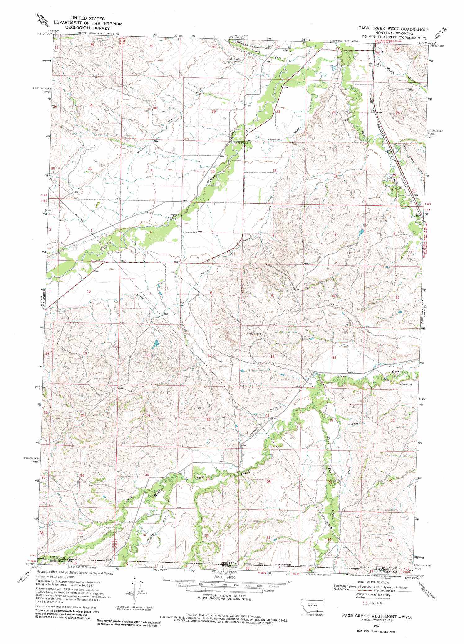
USGS Topo Quad 45107a4 - 1:24,000 scale
| Topo Map Name: | Pass Creek West |
| USGS Topo Quad ID: | 45107a4 |
| Print Size: | ca. 21 1/4" wide x 27" high |
| Southeast Coordinates: | 45° N latitude / 107.375° W longitude |
| Map Center Coordinates: | 45.0625° N latitude / 107.4375° W longitude |
| U.S. States: | MT, WY |
| Filename: | o45107a4.jpg |
| Download Map JPG Image: | Pass Creek West topo map 1:24,000 scale |
| Map Type: | Topographic |
| Topo Series: | 7.5´ |
| Map Scale: | 1:24,000 |
| Source of Map Images: | United States Geological Survey (USGS) |
| Alternate Map Versions: |
Pass Creek West MT 1967, updated 1971 Download PDF Buy paper map Pass Creek West MT 2011 Download PDF Buy paper map Pass Creek West MT 2014 Download PDF Buy paper map |
1:24,000 Topo Quads surrounding Pass Creek West
Mission Coulee |
Shick Ranch |
Good Luck Creek |
Lodge Grass |
Wolf Mountain Lookout |
Dry Soap Creek |
Willow Creek Dam |
Wyola |
Wyola Ne |
Kid Creek |
Willow Creek Dam Sw |
Black Gulch |
Pass Creek West |
Pass Creek East |
Little Bear Creek |
Bull Elk Park |
West Pass |
Columbus Peak |
Dayton North |
Ranchester |
Ice Creek |
Burgess Junction |
Skull Ridge |
Dayton South |
Wolf |
> Back to 45107a1 at 1:100,000 scale
> Back to 45106a1 at 1:250,000 scale
> Back to U.S. Topo Maps home
Pass Creek West topo map: Gazetteer
Pass Creek West: Canals
Bozeman Trail Ditch elevation 1195m 3920′Campbell Belken Ditch elevation 1147m 3763′
Hardy Ditch elevation 1286m 4219′
Stevens Ditch elevation 1283m 4209′
Upper Little Bighorn Canal Number Two elevation 1201m 3940′
Woodley Ditch elevation 1334m 4376′
Pass Creek West: Dams
Resettlement FSA Number 1 Dam elevation 1234m 4048′Pass Creek West: Streams
Crazy Creek elevation 1140m 3740′East Pass Creek elevation 1249m 4097′
East Pass Creek elevation 1248m 4094′
Gay Creek elevation 1311m 4301′
West Pass Creek elevation 1247m 4091′
West Pass Creek elevation 1250m 4101′
Pass Creek West: Wells
08S35E22CBBB01 Well elevation 1135m 3723′08S35E22CBBC01 Well elevation 1136m 3727′
08S35E23CBAA01 Well elevation 1148m 3766′
08S35E23CBCB01 Well elevation 1139m 3736′
08S35E26CDBB01 Well elevation 1153m 3782′
08S35E27AABC01 Well elevation 1141m 3743′
08S35E28ABAC01 Well elevation 1147m 3763′
08S35E28BDDD01 Well elevation 1147m 3763′
08S35E29DCAD01 Well elevation 1160m 3805′
08S35E32ABD_01 Well elevation 1160m 3805′
08S35E32ADDA01 Well elevation 1159m 3802′
08S35E32CADA01 Well elevation 1165m 3822′
08S35E32CDCB01 Well elevation 1171m 3841′
08S35E35ABCC01 Well elevation 1159m 3802′
09S34E01CDBB01 Well elevation 1217m 3992′
09S34E12ABBA01 Well elevation 1196m 3923′
09S34E12BCBB01 Well elevation 1202m 3943′
09S35E04BBBA01 Well elevation 1181m 3874′
09S35E04BBBB01 Well elevation 1178m 3864′
09S35E06CBDD01 Well elevation 1188m 3897′
09S35E21DBCA01 Well elevation 1263m 4143′
09S35E27BDAA01 Well elevation 1276m 4186′
09S35E31CAAB01 Well elevation 1334m 4376′
Pass Creek West digital topo map on disk
Buy this Pass Creek West topo map showing relief, roads, GPS coordinates and other geographical features, as a high-resolution digital map file on DVD:
Eastern Montana & Western North Dakota
Buy digital topo maps: Eastern Montana & Western North Dakota