Wyola Topo Map Montana
To zoom in, hover over the map of Wyola
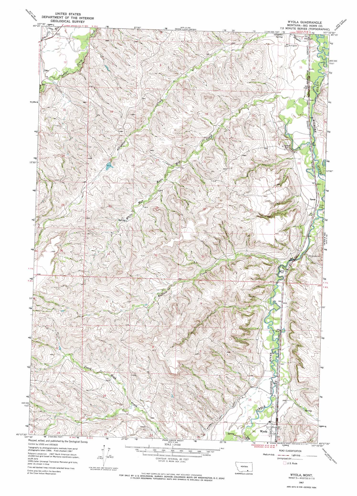
USGS Topo Quad 45107b4 - 1:24,000 scale
| Topo Map Name: | Wyola |
| USGS Topo Quad ID: | 45107b4 |
| Print Size: | ca. 21 1/4" wide x 27" high |
| Southeast Coordinates: | 45.125° N latitude / 107.375° W longitude |
| Map Center Coordinates: | 45.1875° N latitude / 107.4375° W longitude |
| U.S. State: | MT |
| Filename: | o45107b4.jpg |
| Download Map JPG Image: | Wyola topo map 1:24,000 scale |
| Map Type: | Topographic |
| Topo Series: | 7.5´ |
| Map Scale: | 1:24,000 |
| Source of Map Images: | United States Geological Survey (USGS) |
| Alternate Map Versions: |
Wyola MT 1967, updated 1971 Download PDF Buy paper map Wyola MT 2011 Download PDF Buy paper map Wyola MT 2014 Download PDF Buy paper map |
1:24,000 Topo Quads surrounding Wyola
Saint Xavier |
Saint Xavier Ne |
Benteen |
Lodge Grass Ne |
Thompson Creek Nw |
Mission Coulee |
Shick Ranch |
Good Luck Creek |
Lodge Grass |
Wolf Mountain Lookout |
Dry Soap Creek |
Willow Creek Dam |
Wyola |
Wyola Ne |
Kid Creek |
Willow Creek Dam Sw |
Black Gulch |
Pass Creek West |
Pass Creek East |
Little Bear Creek |
Bull Elk Park |
West Pass |
Columbus Peak |
Dayton North |
Ranchester |
> Back to 45107a1 at 1:100,000 scale
> Back to 45106a1 at 1:250,000 scale
> Back to U.S. Topo Maps home
Wyola topo map: Gazetteer
Wyola: Canals
Sloan Ditch elevation 1078m 3536′Wyola: Dams
Crow Number 69 Dam elevation 1244m 4081′Wyola: Populated Places
Spear elevation 1090m 3576′Wyola elevation 1134m 3720′
Wyola: Post Offices
Wyola Post Office elevation 1131m 3710′Wyola: Springs
Alligator Spring elevation 1081m 3546′Wyola: Streams
Buffalo Creek elevation 1099m 3605′Halfway Creek elevation 1092m 3582′
Pass Creek elevation 1130m 3707′
White Man Runs Him Creek elevation 1068m 3503′
Wyola Creek elevation 1121m 3677′
Wyola: Wells
07S34E12ABBB01 Well elevation 1117m 3664′07S34E12ABBB02 Well elevation 1118m 3667′
07S35E11ACAA01 Well elevation 1062m 3484′
07S35E11ACAA02 Well elevation 1062m 3484′
07S35E11ACAD01 Well elevation 1062m 3484′
07S35E11ADBA01 Well elevation 1062m 3484′
07S35E11DBCB01 Well elevation 1067m 3500′
07S35E11DCADO1 Well elevation 1068m 3503′
07S35E14ACC01_ Well elevation 1073m 3520′
07S35E23ABCC01 Well elevation 1080m 3543′
07S35E23BDDB01 Well elevation 1092m 3582′
07S35E26DAB_01 Well elevation 1092m 3582′
08S35E11BCAC01 Well elevation 1110m 3641′
08S35E14BCCB01 Well elevation 1120m 3674′
08S35E14BDBB01 Well elevation 1122m 3681′
08S35E15ACAA01 Well elevation 1119m 3671′
08S35E15DCDA01 Well elevation 1125m 3690′
08S35E15DDBD01 Well elevation 1123m 3684′
Wyola digital topo map on disk
Buy this Wyola topo map showing relief, roads, GPS coordinates and other geographical features, as a high-resolution digital map file on DVD:
Eastern Montana & Western North Dakota
Buy digital topo maps: Eastern Montana & Western North Dakota