Little Dry Creek Topo Map Montana
To zoom in, hover over the map of Little Dry Creek
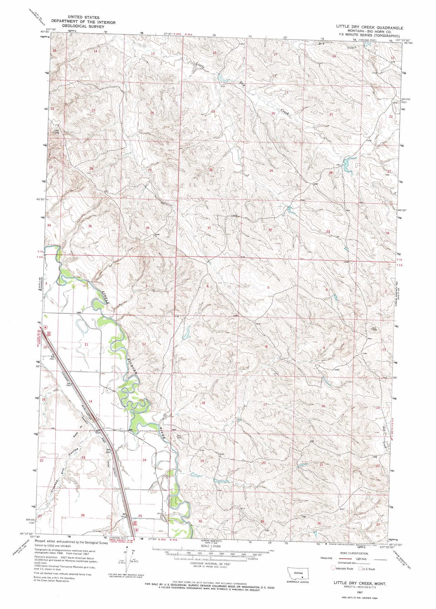
USGS Topo Quad 45107f4 - 1:24,000 scale
| Topo Map Name: | Little Dry Creek |
| USGS Topo Quad ID: | 45107f4 |
| Print Size: | ca. 21 1/4" wide x 27" high |
| Southeast Coordinates: | 45.625° N latitude / 107.375° W longitude |
| Map Center Coordinates: | 45.6875° N latitude / 107.4375° W longitude |
| U.S. State: | MT |
| Filename: | o45107f4.jpg |
| Download Map JPG Image: | Little Dry Creek topo map 1:24,000 scale |
| Map Type: | Topographic |
| Topo Series: | 7.5´ |
| Map Scale: | 1:24,000 |
| Source of Map Images: | United States Geological Survey (USGS) |
| Alternate Map Versions: |
Little Dry Creek MT 1967, updated 1971 Download PDF Buy paper map Little Dry Creek MT 2011 Download PDF Buy paper map Little Dry Creek MT 2014 Download PDF Buy paper map |
1:24,000 Topo Quads surrounding Little Dry Creek
Lemon Ranch |
Foster |
Dudley Spring |
Hammond Ranch |
Iron Spring |
Chimney Creek |
Ninemile Point |
The Dugout |
Padlock Ranch |
Iron Spring Sw |
Walker Hill |
Hardin |
Little Dry Creek |
Crow Agency Ne |
Jeans Fork Nw |
Hardin Sw |
Prante Ranch |
Crow Agency |
Crow Agency Se |
Jeans Fork Sw |
Saint Xavier |
Saint Xavier Ne |
Benteen |
Lodge Grass Ne |
Thompson Creek Nw |
> Back to 45107e1 at 1:100,000 scale
> Back to 45106a1 at 1:250,000 scale
> Back to U.S. Topo Maps home
Little Dry Creek topo map: Gazetteer
Little Dry Creek: Canals
Agency Canal elevation 915m 3001′Little Dry Creek: Dams
Crow Number 4 Dam elevation 1003m 3290′Crow Number 5 Dam elevation 1008m 3307′
D G Orchowski Number 1 Dam elevation 951m 3120′
D G Orchowski Number 2 Dam elevation 940m 3083′
D S Scott Number 1 Dam elevation 954m 3129′
Little Dry Creek: Summits
Abbots Urn elevation 1049m 3441′Haystack Butte elevation 976m 3202′
Little Dry Creek: Valleys
Crooked Arm Coulee elevation 920m 3018′Little Dry Creek: Wells
02S34E01AC__02 Well elevation 954m 3129′02S34E01AC__03 Well elevation 954m 3129′
02S34E02CBCA01 Well elevation 903m 2962′
02S34E02CC__01 Well elevation 904m 2965′
02S34E02CC__02 Well elevation 904m 2965′
02S34E02CD__01 Well elevation 905m 2969′
02S34E02CDDC01 Well elevation 904m 2965′
02S34E02DC__01 Well elevation 904m 2965′
02S34E03AA__02 Well elevation 898m 2946′
02S34E03AACC01 Well elevation 898m 2946′
02S34E03DA__01 Well elevation 902m 2959′
02S34E10AABB01 Well elevation 905m 2969′
02S34E10DA__02 Well elevation 911m 2988′
02S34E11AACC01 Well elevation 904m 2965′
02S34E11CC__02 Well elevation 913m 2995′
02S34E11DA__01 Well elevation 910m 2985′
02S34E11DCCD01 Well elevation 909m 2982′
02S34E13CB__01 Well elevation 912m 2992′
02S34E13CBAB01 Well elevation 909m 2982′
02S34E13CC__01 Well elevation 915m 3001′
02S34E13CD__01 Well elevation 913m 2995′
02S34E13CDDD01 Well elevation 914m 2998′
02S34E13DD__01 Well elevation 926m 3038′
02S34E14AA__01 Well elevation 909m 2982′
02S34E14AB__02 Well elevation 912m 2992′
02S34E14ABDC01 Well elevation 912m 2992′
02S34E14BA__01 Well elevation 913m 2995′
02S34E14CA__01 Well elevation 927m 3041′
02S34E23AA__01 Well elevation 921m 3021′
02S34E23AAAC01 Well elevation 918m 3011′
02S34E23AD__01 Well elevation 934m 3064′
02S34E23CBAA01 Well elevation 928m 3044′
02S34E24ABAB01 Well elevation 915m 3001′
02S34E24DA__01 Well elevation 915m 3001′
02S34E24DB__01 Well elevation 917m 3008′
02S34E24DBDD01 Well elevation 916m 3005′
02S34E24DC__01 Well elevation 916m 3005′
02S34E24DD__01 Well elevation 916m 3005′
02S34E25AD__01 Well elevation 915m 3001′
02S34E25BB__01 Well elevation 922m 3024′
02S34E25BBAB01 Well elevation 921m 3021′
02S34E25BD__01 Well elevation 921m 3021′
02S34E25CA__01 Well elevation 925m 3034′
02S34E25CA__02 Well elevation 925m 3034′
02S35E30CB__01 Well elevation 919m 3015′
Little Dry Creek digital topo map on disk
Buy this Little Dry Creek topo map showing relief, roads, GPS coordinates and other geographical features, as a high-resolution digital map file on DVD:
Eastern Montana & Western North Dakota
Buy digital topo maps: Eastern Montana & Western North Dakota