Chilkoot Coulee Topo Map Montana
To zoom in, hover over the map of Chilkoot Coulee
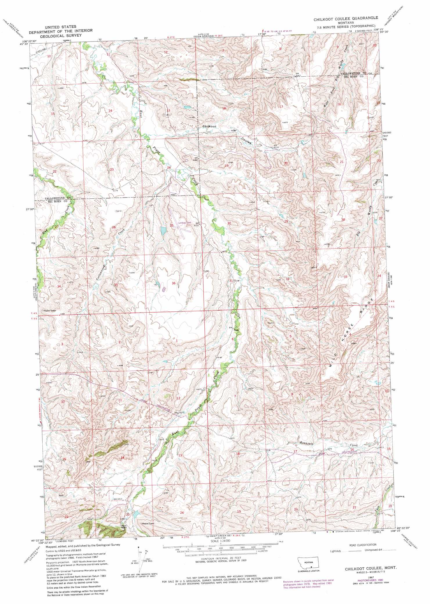
USGS Topo Quad 45108d3 - 1:24,000 scale
| Topo Map Name: | Chilkoot Coulee |
| USGS Topo Quad ID: | 45108d3 |
| Print Size: | ca. 21 1/4" wide x 27" high |
| Southeast Coordinates: | 45.375° N latitude / 108.25° W longitude |
| Map Center Coordinates: | 45.4375° N latitude / 108.3125° W longitude |
| U.S. State: | MT |
| Filename: | o45108d3.jpg |
| Download Map JPG Image: | Chilkoot Coulee topo map 1:24,000 scale |
| Map Type: | Topographic |
| Topo Series: | 7.5´ |
| Map Scale: | 1:24,000 |
| Source of Map Images: | United States Geological Survey (USGS) |
| Alternate Map Versions: |
Chilkoot Coulee MT 1967, updated 1972 Download PDF Buy paper map Chilkoot Coulee MT 1967, updated 1980 Download PDF Buy paper map Chilkoot Coulee MT 2011 Download PDF Buy paper map Chilkoot Coulee MT 2014 Download PDF Buy paper map |
1:24,000 Topo Quads surrounding Chilkoot Coulee
Yegen |
Soda Springs Nw |
Badbaby Coulee |
Woody Mountain Nw |
North Telegraph Creek |
Stratford Hill |
Vale Creek Ranch |
Soda Springs |
Woody Mountain |
Woody Mountain Se |
Pryor |
Deep Creek |
Chilkoot Coulee |
Bear Coulee |
Mott Creek |
Castle Rocks |
Deep Creek Sw |
Deep Creek Se |
Bear Coulee Sw |
Grapevine Dome |
Indian Spring |
Big Ice Cave |
East Pryor Mountain |
Dead Indian Hill |
Little Finger Ridge |
> Back to 45108a1 at 1:100,000 scale
> Back to 45108a1 at 1:250,000 scale
> Back to U.S. Topo Maps home
Chilkoot Coulee topo map: Gazetteer
Chilkoot Coulee: Dams
Crow Number 12 Dam elevation 1245m 4084′Pryor Land Number 1 Dam elevation 1341m 4399′
Chilkoot Coulee: Streams
Cottonwood Creek elevation 1207m 3959′Chilkoot Coulee: Valleys
Chilkoot Coulee elevation 1204m 3950′Chilkoot Coulee: Wells
05S28E22BCDC01 Well elevation 1275m 4183′Chilkoot Coulee digital topo map on disk
Buy this Chilkoot Coulee topo map showing relief, roads, GPS coordinates and other geographical features, as a high-resolution digital map file on DVD: