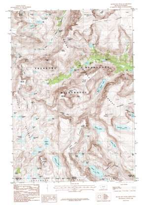
Silver Run Peak Topo Map Montana
To zoom in, hover over the map of Silver Run Peak
USGS Topo Quad 45109a5 - 1:24,000 scale
| Topo Map Name: | Silver Run Peak |
| USGS Topo Quad ID: | 45109a5 |
| Print Size: | ca. 21 1/4" wide x 27" high |
| Southeast Coordinates: | 45° N latitude / 109.5° W longitude |
| Map Center Coordinates: | 45.0625° N latitude / 109.5625° W longitude |
| U.S. States: | MT, WY |
| Filename: | o45109a5.jpg |
| Download Map JPG Image: | Silver Run Peak topo map 1:24,000 scale |
| Map Type: | Topographic |
| Topo Series: | 7.5´ |
| Map Scale: | 1:24,000 |
| Source of Map Images: | United States Geological Survey (USGS) |
| Alternate Map Versions: |
Silver Run Peak MT 1986, updated 1986 Download PDF Buy paper map Silver Run Peak MT 1996, updated 1999 Download PDF Buy paper map Silver Run Peak MT 2011 Download PDF Buy paper map Silver Run Peak MT 2014 Download PDF Buy paper map |
| FStopo: | US Forest Service topo Silver Run Peak is available: Download FStopo PDF Download FStopo TIF |
1:24,000 Topo Quads surrounding Silver Run Peak
> Back to 45109a1 at 1:100,000 scale
> Back to 45108a1 at 1:250,000 scale
> Back to U.S. Topo Maps home
Silver Run Peak topo map: Gazetteer
Silver Run Peak: Dams
Glacier Lake North Dam elevation 2955m 9694′Glacier Lake South Dam elevation 3005m 9858′
Silver Run Peak: Gaps
Sundance Pass elevation 3350m 10990′Silver Run Peak: Glaciers
Beartooth Glacier elevation 3200m 10498′Grasshopper Glacier elevation 3062m 10045′
Hopper Glacier elevation 3236m 10616′
Silver Run Peak: Lakes
Abandoned Lake elevation 3059m 10036′Albino Lake elevation 3045m 9990′
Arrowhead Lake elevation 3152m 10341′
Black Canyon Lake elevation 2787m 9143′
Bowback Lake elevation 3168m 10393′
Cloverleaf Lakes elevation 3098m 10164′
Donelson Lake elevation 3182m 10439′
First Rock Lake elevation 2693m 8835′
Frosty Lake elevation 3349m 10987′
Goat Lake elevation 3059m 10036′
Golden Lake elevation 3079m 10101′
High Pass Lake elevation 3310m 10859′
Jasper Lake elevation 3089m 10134′
Keyser Brown Lake elevation 2656m 8713′
Kookoo Lake elevation 3117m 10226′
Little Glacier Lake elevation 2961m 9714′
Lonesome Lake elevation 3059m 10036′
Lost Lake elevation 2590m 8497′
Marker Lake elevation 3314m 10872′
Moon Lake elevation 3166m 10387′
Omega Lake elevation 3314m 10872′
Second Rock Lake elevation 2777m 9110′
September Morn Lake elevation 2957m 9701′
Shadow Lake elevation 2920m 9580′
Sheep Lake elevation 3057m 10029′
Shelf Lake elevation 3098m 10164′
Ship Lake elevation 3190m 10465′
Silt Lakes elevation 2998m 9835′
Silver Tarn elevation 3314m 10872′
Sky Pilot Lake elevation 3195m 10482′
Sliderock Lake elevation 3185m 10449′
Sundance Lake elevation 2885m 9465′
Triangle Lake elevation 3170m 10400′
Triskele Lake elevation 3105m 10187′
Two Bits Lake elevation 3114m 10216′
Silver Run Peak: Reservoirs
Glacier Lake elevation 2955m 9694′Glacier Lake elevation 2955m 9694′
Silver Run Peak: Ridges
Bears Tooth elevation 3380m 11089′Silver Run Peak: Summits
Beartooth Mountain elevation 3763m 12345′Lonesome Mountain elevation 3453m 11328′
Medicine Mountain elevation 3512m 11522′
Metcalf Mountain elevation 3468m 11377′
Mount Lockhart elevation 3535m 11597′
Mount Rearguard elevation 3705m 12155′
Silver Run Peak elevation 3803m 12477′
Spirit Mountain elevation 3746m 12290′
Sundance Mountain elevation 3728m 12230′
Thunder Mountain elevation 3475m 11400′
Whitetail Peak elevation 3821m 12536′
Silver Run Peak digital topo map on disk
Buy this Silver Run Peak topo map showing relief, roads, GPS coordinates and other geographical features, as a high-resolution digital map file on DVD:


